Forecast for the Moab Area Mountains

Eric Trenbeath
Issued by Eric Trenbeath for
Monday, January 16, 2023
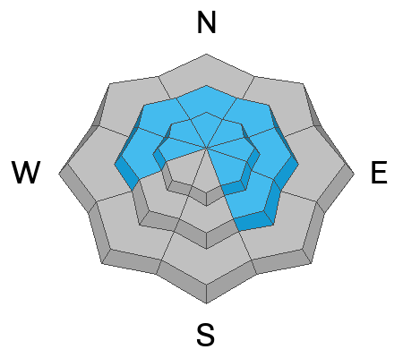
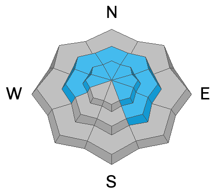
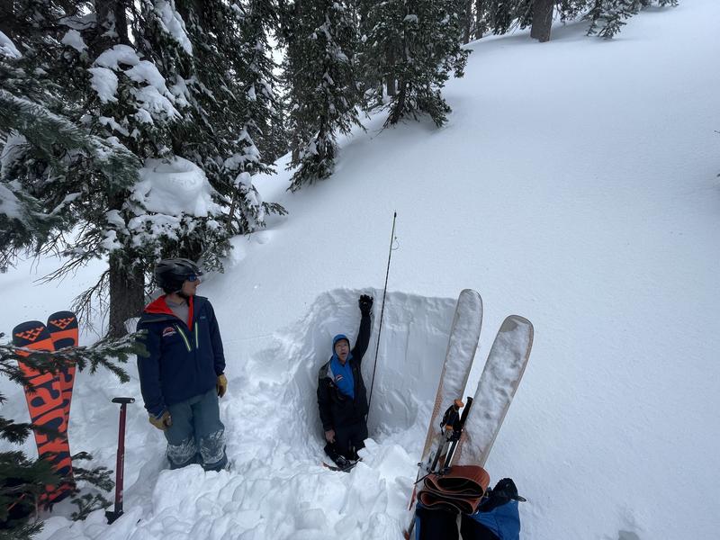
The avalanche danger is CONSIDERABLE on steep slopes near treeline and above that face NW-N-NE-E and human triggered avalanches involving recent and wind drifted snow are likely. In isolated areas, avalanches triggered in the new snow could step down to the buried persistent weak layer causing a deeper and more dangerous avalanche.

A MODERATE danger exists on all other aspects and elevations, and human triggered avalanches involving new and wind drifted snow are possible.

Travel advice: Avoid slopes steeper than 30 degrees that have recent deposits of wind drifted snow or that show signs of instability such as cracking in the snow surface. Utilize test slopes to see how the new snow is behaving before committing to steeper terrain. Avoid all, steep, northerly aspects.
Low
Moderate
Considerable
High
Extreme
Learn how to read the forecast here
Special Announcements
Our Backcountry 101 class is full. We look forward to seeing everyone this weekend!
Road Conditions: The road is challenging with areas of drifted snow and deep ruts. 4x4, high clearance, and possibly chains are required. Plowing is scheduled for tomorrow with assistance from a USFS bulldozer to widen the road. Expect the road to be closed for most of the day.
Grooming: All trails will be covered in new snow today.
Weather and Snow
24 Hour Snow 8" 72 Hour Snow 14" Season Total Snow 152" Base Depth at Gold Basin 69"
Winds on Pre Laurel Peak SSW 3-5 Temp 19F

Weather
SW winds will be on the increase today as the next system moves into the area. Looking like a repeat performance of yesterday's event, we should see snow starting this afternoon and continuing through Tuesday night with another foot or more looking likely. By Wednesday, the flow shifts to the NW, and we're starting to see signs of a transition away from the current weather pattern that has been characterized by atmospheric rivers and warm southwest flow. Nevertheless, unsettled weather and another chance for snow on Thursday finishes out the week.
General Conditions
In our travels yesterday we found excellent storm skiing and riding conditions with continued snowfall throughout the day. The dense, new snow was forming a cohesive slab over the lower density, old snow surface, and this process was aided by sustained southerly winds that blew and drifted snow at all elevations. We observed lots of cracking and found fresh, unstable drifts 18"-24" deep. Charlie Ramser observed similar conditions. The new snow will be less sensitive today, but human triggered avalanches remain possible, with the greatest likelihood found on steep, northerly aspects.
The November persistent weak layer is deeply buried in most areas and is becoming harder to affect. Areas of concern include places where the snowpack is thinner like along slope margins, near rocky outcrops, or along steep convexities. We are once again testing it with a new load of snow and more is on the way. For now, let's steer clear of steep, northerly facing terrain until the dust settles so to speak.
In our travels yesterday we encountered lots of cracking the snow surface indicating unstable slabs of wind drifted snow as well as slabs within the most recent storm snow.

Snowpack and Weather Data
Gold Basin Storm Stake (10,000')
Gold Basin SNOTEL site (10,000')
SNOTEL site near Geyser Pass Winter Trailhead (9600')
Wind Station on Pre-Laurel Peak (11,400')
NWS forecast for the La Sal Mountains.
Recent Avalanches
No new avalanches have been reported. Here is the La Sal Avalanche Database.
Ad
Avalanche Problem #1
Wind Drifted Snow
Type
Location
Likelihood
Size
Description
Strong southwesterly winds yesterday drifted snow into dense, cohesive slabs across the landscape. Isolated drifts may be found on all aspects and elevations, but the problem is fairly widespread on slopes near and above treeline that face W-N-SE. On northerly aspects, drifts 18" -24" deep have developed. In and of themselves, these drifts are deep enough to cause a day ruining avalanche. In a worst case scenario, a tirggered wind slab could step down to the buried persistent weak layer causing a deeper and more dangerous, life ending avalanche. Avoid steep, wind drifted slopes today, especially those with a northerly aspect.
Avalanche Problem #2
New Snow
Type
Location
Likelihood
Size
Description
Aided by winds, the dense, new snow that fell yesterday formed a cohesive soft slab on all aspects and elevations. The recent storm snow will be less sensitive today, but pay attention to how it is behaving. Utilize test slopes and look for signs of instability such as cracking in the snow surface. Blocks of snow between your skis on the skin trail indicate that a slab has developed. In thinner snowpack areas, or in areas of more radical terrain, a triggered storm slab could step down into the buried persistent weak layer causing a deeper and more dangerous avalanche.
Avalanche Problem #3
Persistent Weak Layer
Type
Location
Likelihood
Size
Description
The widespread persistent weak layer (PWL) that formed in November is showing signs of strengthening and stability tests continue to be less reactive. This means avalanches are becoming harder to trigger but the consequences remain the same. Any avalanche triggered on this deeply buried PWL would be large and un-survivable. The greatest risk exists on steep, wind drifted, northerly aspects above treeline. As we start to think about easing into larger terrain, areas to avoid include slopes with steep convexities or blind break-overs; thin snowpack areas along slope margins or near rock outcrops; and areas of steep, rocky, more radical terrain.
A deep and strengthening snowpack exists in most areas near treeline and below. In these areas the November persistent weak layer is deeply buried and becoming harder to affect. Above treeline, snow depths are much more variable and trigger points are much more plentiful, and the problem can't be ruled out yet.
Additional Information
Check out this Week in Review video for a recap of snow conditions prior to the storm.
General Announcements
This forecast is from the U.S.D.A. Forest Service, which is solely responsible for its content. This forecast describes general avalanche conditions and local variations always occur. This forecast will be updated by 7:30 tomorrow morning.