Check Out Our Holiday Auction!

Forecast for the Moab Area Mountains

Dave Garcia
Issued by Dave Garcia on
Wednesday morning, December 3, 2025
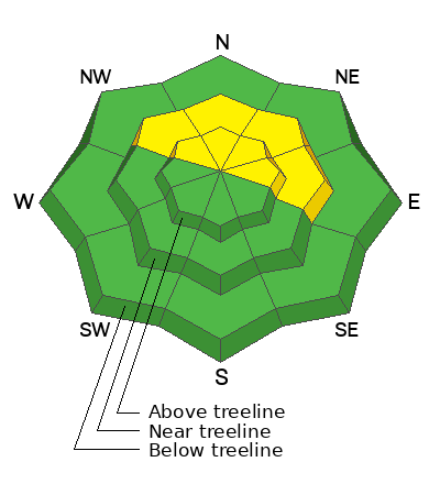
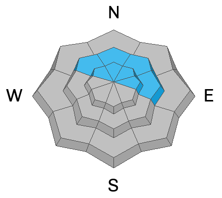
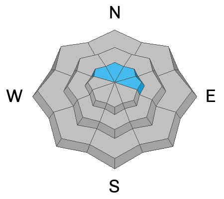
The avalanche danger is MODERATE on steep NW–N–NE–E facing slopes near and above treeline. Human-triggered shallow soft slabs breaking on a persistent weak layer are possible. On these same slopes, there is a MODERATE danger for avalanches failing in wind-drifted snow. Shallow, pockety avalanches can have serious consequences, given our thin early-season snowpack.
Conditions remain very thin, and rocks, stumps, and logs lurk below the surface everywhere. There still isn't quite enough snow for real turning and riding. Exercise extreme caution getting around.
Low
Moderate
Considerable
High
Extreme
Learn how to read the forecast here
Special Announcements

Geyser Pass Road Conditions: The road has not been plowed and you will find 4-8 inches of new snow on top of the old icy and snow packed surface. 4 wheel drive is required.

It's Avalanche Awareness Week!

Tonight - Don't miss our free Know Before You Go avalanche awareness talk at the Moab Arts and Recreation Center, 111 E 100 N at 5:30 p.m.

Saturday, December 6 - 18th Annual Utah Snow and Avalanche Workshop (USAW). This session will be held in-person at the Wasatch Jr High School Auditorium. 3750 S 3100 E, Salt Lake City, UT 84109. Information and tickets are available here.

Saturday, December 13 - Winter Kick Off Party Bring your skis or board to wax, listen to live music, and bring in another winter season with our local community. Tickets available online now!

Weather and Snow

24 Hour Snow: 1" 72 Hour Snow: 10" Season Total Snow: 21" Depth at Gold Basin: 17"

Winds on Pre-Laurel Peak: 5 NW Temp: 18° F

Weather

A weak short wave on a northerly flow will continue to bring light snow showers to our region. Skies will be mostly cloudy, and snowfall is expected to taper off by this afternoon. Any additional accumulation will be light, with 1-2 inches possible. Winds will be light out of the northeast, and temperatures will hover around 20°F. Skies will clear tonight. The rest of the week will be sunny and calm with highs in the mid-20s°F. Beginning Friday, the flow becomes northwesterly, and the mountains of northern Utah and Colorado will see accumulating snow. A weak ridge over the Four Corners looks to leave us high and dry, but light snowfall may become possible this weekend.

General Conditions

Travel was somewhat difficult while cruising around the Laurel Highway and Gold Basin yesterday. I found deep trail breaking off the beaten path that made for slow going. The average height of snow above 10,000' is 18-24". The snowpack is weak and faceted, allowing skis to punch deep when traveling downhill and attempting to make turns. Rocks and logs are a real hazard right now, and the punchy snow doesn't help. The good news is that soft powder exists on all aspects, so if you can find a grassy slope, you might be able to make some turns.

Old, pre-existing faceted snow was buried by 9 inches of storm snow on Sunday, laying an evenly distributed slab on top of a persistent weak layer. We observed numerous small avalanches on Monday, and test results continue to be sensitive. Avalanche danger is most prevalent on northerly aspects where the snowpack is deeper and more well-connected. The weak layer is especially sensitive, and above treeline slopes that have seen just a touch of wind-drifted snow are especially suspect.

Poor snowpack structure also exists on slopes that face west and southwest. Many slopes near or above treeline with a west or southwest aspect were subject to strong sun and/or strong winds and do not have much of a snowpack at all. The PWL problem does not exist on these slopes. However, if you find yourself on southwest or west-facing slopes, and the snowpack is deep, dig down and look for the weak layer; it is easy to find.

Click here to check out all recent obs, including my fieldwork from Tuesday.

Check out the video below from our fieldwork on Monday

Snowpack and Weather Data

NEW! Gold Basin webcam storm stake

Gold Basin Storm Stake (10,000')

Recent Avalanches
In our travels on Monday, we came across this R2 D2 avalanche in Colorado Bowl. Definitely large enough to bury a person.
Avalanche Problem #1
Persistent Weak Layer
Type
Location
Likelihood
Size
Description

Sunday's storm deposited a very soft slab that now sits on top of weak faceted layers of older snow. In many areas, this slab is still too soft to produce an avalanche, but where it has gained cohesion—especially in wind-loaded terrain—avalanches large enough to bury a person are possible. As the recent snow continues to settle, and the slab becomes denser, the weak layer will become more sensitive. For now, observers are reporting shallow slabs breaking on facets at the old snow surface in stability tests.

The photo below, from my fieldwork on Tuesday, illustrates the results of an extended column test (ECTP 9) with a soft slab failure on facets at the old snow surface.

Avalanche Problem #2
Wind Drifted Snow
Type
Location
Likelihood
Size
Description
Monday night's brief wind event drifted snow above treeline on slopes facing NW-N-NE-E. Expect these slopes to remain unstable today. The weak layer is very sensitive, and even the slightest bit of drifting is a recipe for a human-triggered avalanche. Given the shallow, early-season conditions, any triggered avalanche would prove to be a rough ride.
Additional Information

It's never too early to start thinking about avalanches. Here are a few things to consider doing:

  • Learn online. We have over 5 hours of free online learning at the Know Before You Go website
  • Check out the upcoming in-person Know Before You Go events HERE
  • Sign up for an on-snow class
  • Check out the UAC's education progression HERE
  • Get your avalanche rescue gear ready for winter. Put fresh batteries in your transceiver and update the firmware. Inspect your shovel and probe. Get your airbag backpack ready by possibly doing a test deployment and updating the firmware if it is an electric version or getting your canister refilled if it's not electronic.
General Announcements
This forecast is from the U.S.D.A. Forest Service, which is solely responsible for its content. This forecast describes general avalanche conditions and local variations always occur.