31st Annual Backcountry Benefit - September 12th - Tickets Available Here!

Forecast for the Logan Area Mountains

Toby Weed
Issued by Toby Weed on
Monday morning, April 3, 2023
Heightened avalanche conditions are found at all elevations on backcountry slopes steeper than 30°. Heavy snowfall will elevate the danger to CONSIDERABLE, with dangerous conditions, especially in drifted mid and upper elevation terrain. Large natural cornice falls are possible, and these or people are likely to trigger 1' to 3' thick and 100-200' wide slab avalanches of storm snow. We will find very nice deep powder riding conditions in lower angle terrain and in the meadows out from under steep slopes.

Dangerous avalanche conditions dictate careful snow and terrain evaluation as well as cautious decision making.
Low
Moderate
Considerable
High
Extreme
Learn how to read the forecast here
Weather and Snow
Moderate winds overnight only drifted the fresh snow near ridge tops, loading primarily just the upper reaches of avalanche starting zones, and heavy snowfall will elevate the danger today. Dangerous conditions exist on recently drifted upper elevation slopes, people are likely to trigger large avalanches, and long running naturals are possible. With several feet of new snow in the past couple days and another foot overnight, soft slab and loose avalanches of storm snow are possible on steep slopes at all elevations, even in sheltered terrain. Natural avalanches are most likely during periods of very heavy snowfall or increased drifting.
Beaver mountain reports 13" in the last 24 hours and it is snowing again this morning. The 8400' Tony Grove Snotel also reports several inches and 1.0" SWE. It's 20°F and there is 164" of total snow. The wind is fairly calm this morning at UDOT's Logan Summit weather station, reading 5 mph from the ESE.
Here is the NWS point forecast (36 hrs) for high elevations in the Central Bear River Range:
Today: Snow. High near 26. Wind chill values as low as 7. South southwest wind 7 to 15 mph becoming northwest in the afternoon. Chance of precipitation is 100%. Total daytime snow accumulation of 4 to 6 inches possible.
Tonight: Snow. The snow could be heavy at times. Low around 11. Wind chill values as low as -3. Northwest wind 9 to 18 mph. Chance of precipitation is 80%. New snow accumulation of 5 to 9 inches possible.
Tuesday: Snow. High near 24. Wind chill values as low as 4. West wind 7 to 13 mph. Chance of precipitation is 100%. New snow accumulation of 3 to 7 inches possible.

The National Weather Service has issued a Winter Storm Warning for the Logan Zone, extending through Tuesday evening. Looks like we'll see a bit of sun on Thursday.
Recent Avalanches
  • I noticed evidence of some large natural avalanches in the Wellsvilles Saturday, but views of the high country were mostly obscured by plumes of snow blowing off the peaks and ridges.
  • A few natural wet loose avalanches occurred at lower elevations in Logan Canyon over the weekend, including a couple slides that went into the Logan River below Temple Fork. There were lots of roller balls and pinwheels.
  • Large natural avalanches occurred early Friday morning in the mountains above North Ogden, including off the Ben Lomond Headwall and a handful, crossing and closing the North Ogden Divide road.
  • For a list of recent avalanches in the Logan Zone go HERE
  • There was lots of natural avalanche activity in the mountains of Northern Utah yesterday. Find a list of all recent observations & avalanches from across Utah HERE.
Ad
Avalanche Problem #1
Wind Drifted Snow
Type
Location
Likelihood
Size
Description
This morning, winds are blowing from the east-southeast and increasing a bit. It was very windy over the weekend, with strong westerly winds. Expect to find dangerous conditions up high, especially in windy terrain with huge, potentially mouse trap sensitive cornices, and thick, freshly formed wind slabs.
  • Large natural or triggered cornice falls are possible, and 2' to 4' thick soft and harder wind slabs are likely for people to trigger in windy terrain at upper and mid elevations.
  • Avoid corniced slopes and stiffer drifts on steep slopes near ridges and in and around terrain features like cliff bands, sub-ridges, mid-slope break-overs, and gully walls.
  • Evidence of instability could include cracking or collapsing, and some avalanches might be triggered remotely or from a distance.
  • The overhanging cornices on the high ridges are huge this year, and recent storms have built them further out and made them unstable, so people should continue to stay well away and out from under them.
Avalanche Problem #2
New Snow
Type
Location
Likelihood
Size
Description
  • With over three feet of recently fallen new snow, soft slab and loose avalanches of storm snow are possible even in generally sheltered terrain on steep slopes where significant new snow accumulated.
  • Natural avalanches are possible during periods of heavy snowfall or when significant drifting rapidly overloads a slope, but they could be triggered by cornice falls or tree bombs at any time.
  • Heightened conditions are found at low elevations, especially in very steep northerly facing terrain including on shady forested slopes.
  • High angle April sun, possible greenhousing, or rain on the snow could quickly moisten the new snow and rapidly increase potential for wet avalanches.
  • Wet avalanches could occur in unexpected places. We have seen numerous wet avalanches at low elevations this year even in places where we've not really seen any avalanches before.
Additional Information
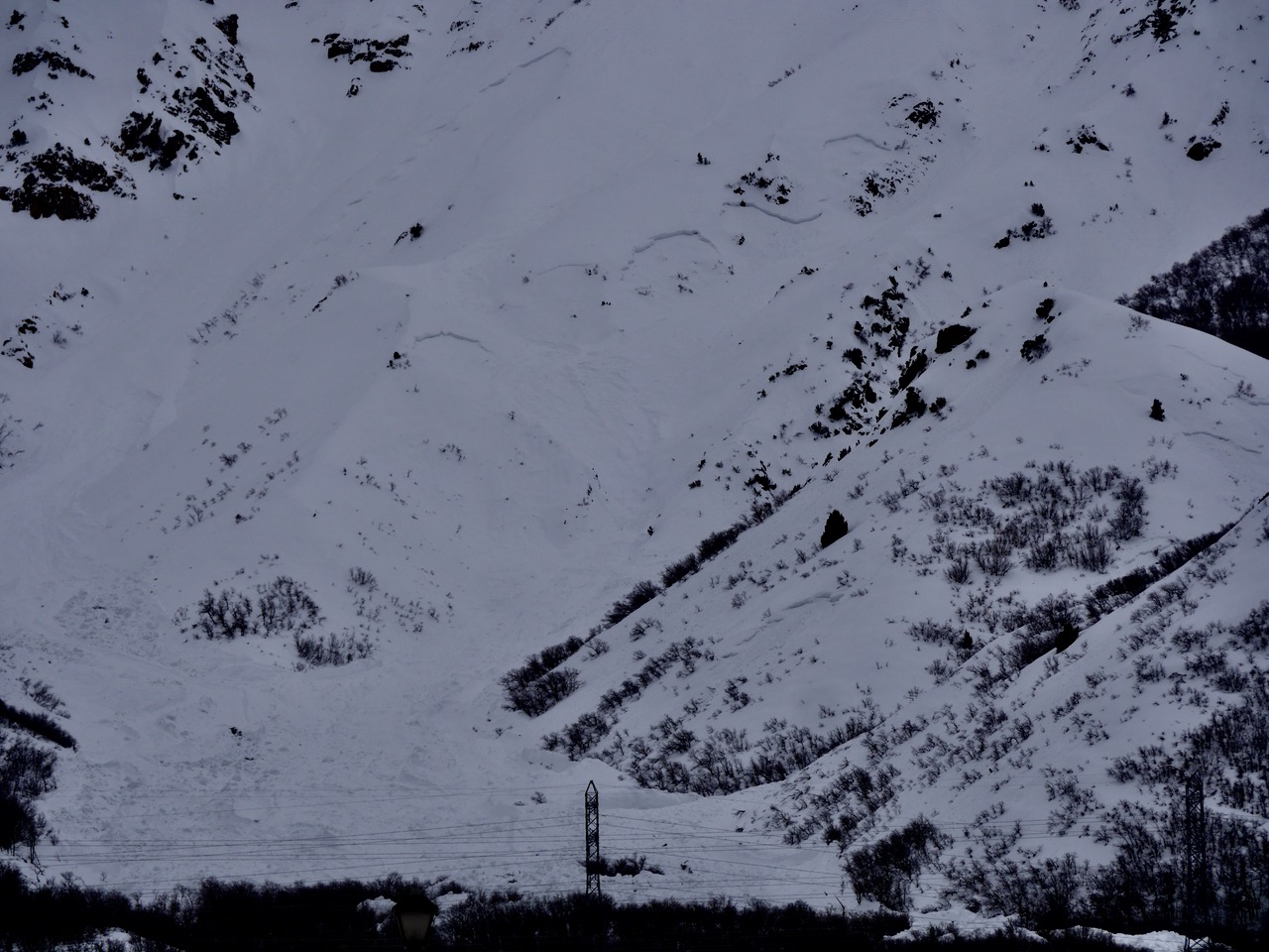
Very large natural avalanches occurred early Friday above Pleasant View and North Ogden, coming off the very steep Ben Lomond Headwall.
General Announcements
  • Please submit your observations from the backcountry HERE.
  • For a list of avalanche classes from the Utah Avalanche Center go HERE
  • For information on where you can ride your sled or snow-bike, check out this map of the winter travel plan for the Logan and Ogden Ranger Districts HERE, and a close up of the Tony Grove and Franklin Basin Areas HERE.
This forecast is from the U.S.D.A. Forest Service, which is solely responsible for its content. This forecast describes general avalanche conditions and local variations always occur.