Forecast for the Logan Area Mountains

Toby Weed
Issued by Toby Weed for
Saturday, April 13, 2024
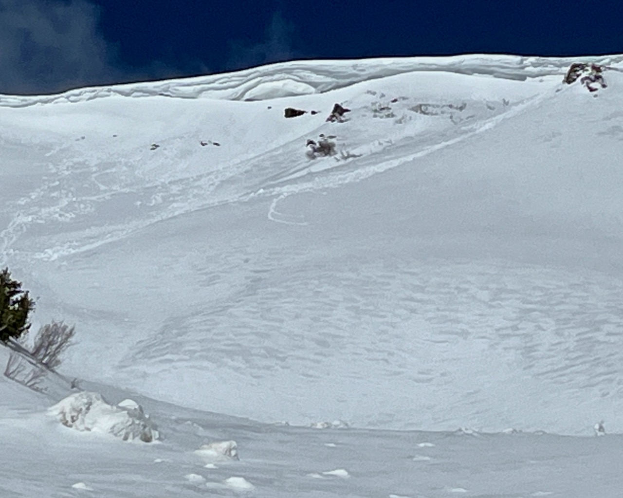
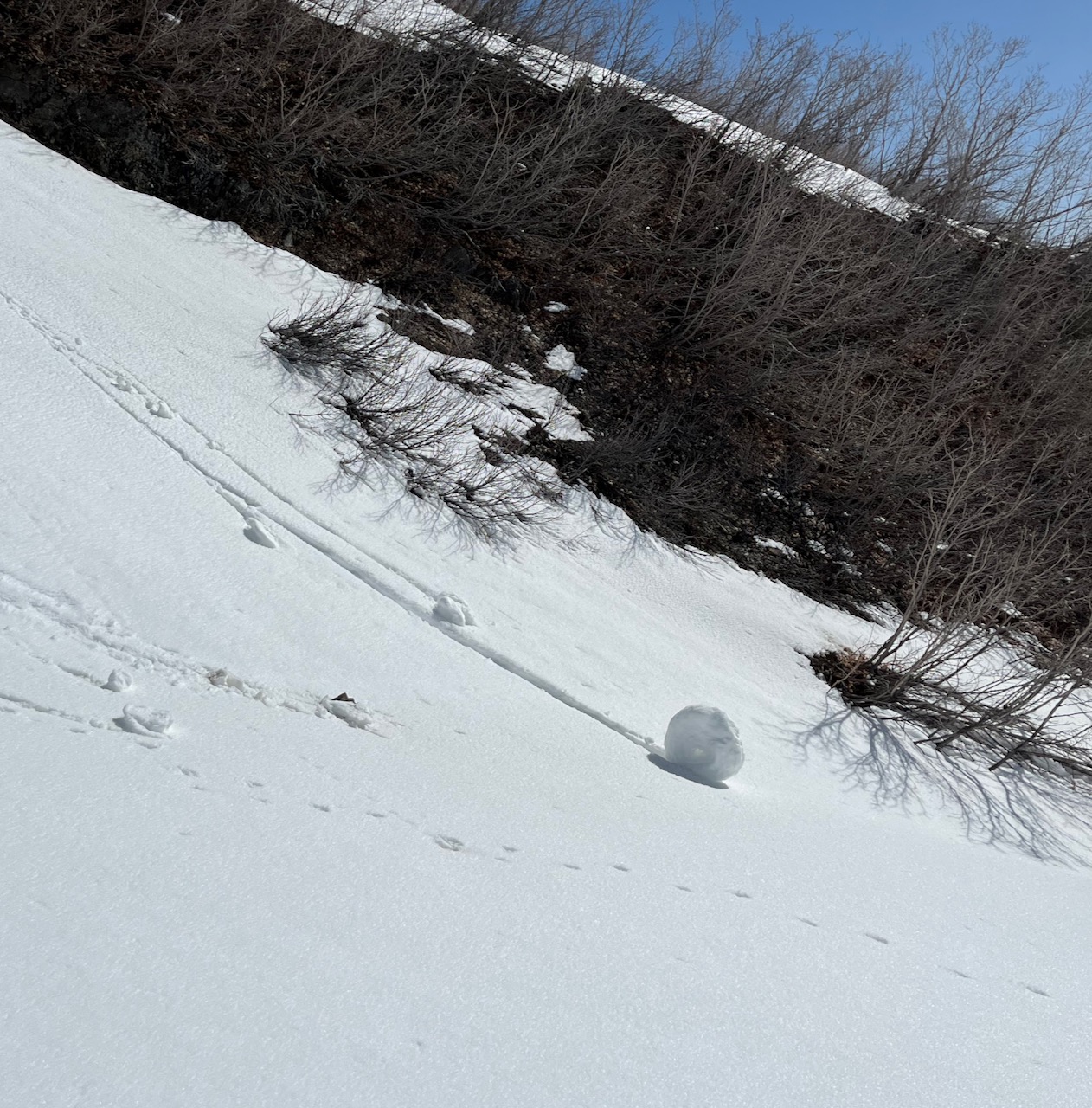
Overnight temperatures stayed well above freezing, and very warm temperatures and intense sun will elevate the avalanche danger to MODERATE at all elevations again today. Heightened conditions will develop on many slopes steeper than 30°, with wet avalanches, glide avalanches, and large natural cornice falls possible.
  • Evaluate snow and terrain carefully.
  • Avoid terrain threatened by large overhanging cornices.
  • Move off and out from under slopes with melt-softened saturated snow in the day's heat.
Low
Moderate
Considerable
High
Extreme
Learn how to read the forecast here
Special Announcements
Gear up for next season or snag deals to close out this season while supporting the UAC’s efforts. Your participation directly funds the state's avalanche forecasting, awareness, and education programs. Check out the auction found HERE! https://e.givesmart.com/events/Cqt/
Weather and Snow
Temperatures again stayed well above freezing overnight at all stations, with 5:00 readings of 40°F on the summit of Paris Peak, 39°F on Logan Peak, 44°F at Card Canyon, and 45°F at Tony Grove Lake. Today, the superficially frozen saturated surface snow will be softened by the heat even earlier in the day, especially in sunny terrain. Today, large natural cornice falls and glide avalanches are possible, and people might trigger wet loose and/or wet slab avalanches.
The snow at lower elevations is melting fast, with no snow or very thin coverage remaining on slopes facing southeast, south, southwest, and west. Despite this, access from the Logan Canyon Trailheads is still good (you ride on snow once you leave the parking areas), and snow coverage is excellent in upper and mid-elevation terrain.
The Tony Grove Lake Snotel at 8400' reports 45°F this morning. There is 92 inches of total snow at the site, which contains 126% of the normal snow water equivalent.
At the 9700' CSI Logan Peak weather station, increasing winds are blowing from the south-southwest at 28 mph with gusts in the mid 40s, and it is 39°F.
At UAC's Paris Peak weather station at 9500', it's 40°F, and at 5:00, the wind is blowing from the south-southwest 20 mph, with gusts to 35 mph.
It's 44°F at UAC's Card Canyon weather station at 8800', and there is 79 inches of total snow.

Expect sunny skies in the mountains today. High temperatures should reach around 53°F at 9500' (and at the tops of the highest peaks in the Bear River Range), and the wind will blow from the south-southwest 16 to 18 mph.
Fair weather conditions in the mountains again tomorrow. It will be mostly sunny, but it will be a little cooler, and there is even a chance for some snow showers up high. High temperatures around 46°F are expected, and the wind will blow from the southwest at 10 to 16 mph.
Snow showers are possible early next week, but little in the way of accumulation is expected.

If you would like more detailed information, you can visit our mountain weather page HERE.
Recent Avalanches
No new avalanches were reported yesterday, but on Thursday, riders observed evidence of expected fresh cornice falls off high ridges in generally east-facing terrain.

Check out all local observations and avalanches HERE.
Ad
Avalanche Problem #1
Cornice
Type
Location
Likelihood
Size
Description
Increasing daytime heat in the next few days will cause overhanging cornices to buckle and sag, and some may naturally calve off large pieces, threatening people who may be on slopes below.
  • Large and overhanging cornices may break further back than expected. Natural cornice falls could trigger wet avalanches on slopes below.
  • As always, practice safe travel protocols to avoid exposing more than one person to avalanche danger.
A very large cornice is overhanging the main face and threatens the climb up Rattlesnake Canyon in the Wellsville Mountain Wilderness.
Avalanche Problem #2
Wet Snow
Type
Location
Likelihood
Size
Description
After another night with above-freezing temperatures and a poor surface refreeze, solar warming and too-hot daytime temperatures will cause the snow to become soft, prone to producing loose wet avalanches that entrain the saturated snow. On sustained slopes, these could produce good-sized piles of heavy cement-like debris. Glide avalanches are possible on steep slopes with smooth ground surfaces or rock slabs underlying the season's snowpack, and both wet loose and more dangerous wet slab avalanches are possible on slopes steeper than 30°.
  • Rapid warming, roller balls, pinwheels, and wet sluffs or small point-release avalanches are red flags indicating unstable wet snow.
  • Watch for signs of instability, like cracking, recent avalanches, or cornice falls on similar slopes.
  • Avoid travel on or under steep slopes with melt-softened saturated snow. Stay off steep slopes above terrain traps like trees, sinks, gullies, or rock bands that small wet avalanches could sweep you into.
Roller balls and pinwheels indicate wet snow instability and are often precursors of larger wet avalanches.
Additional Information
Check out McKinley Talty's recent blog post, "Do We Let Our Guard Down in the Spring?" about springtime mindsets and avalanche incidents... HERE.
General Announcements
-National Forest Winter Recreation Travel Maps show where it's open to ride: UWCNF Logan, Ogden LRD Tony Grove, Franklin Basin CTNF Montpelier
-Sign up for forecast region-specific text message alerts. You will receive messages about changing avalanche conditions, watches, and warnings...HERE.
-For all questions on forecasts, education, Know Before You Go, events, online purchases, or fundraising, call 801-365-5522.
-To report an avalanche or submit an observation from the backcountry, go HERE.
-We will issue regular daily forecasts through Sunday, April 14 (tomorrow!). We will update this forecast tomorrow by 7:30 AM.

This forecast is from the U.S.D.A. Forest Service, which is solely responsible for its content. This forecast describes general avalanche conditions, and local variations always occur.