Donate to Our Spring Campaign or Bid on our Spring Auction to Support Forecasting

Forecast for the Logan Area Mountains

Toby Weed
Issued by Toby Weed on
Thursday morning, March 20, 2025
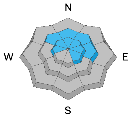
Avalanche conditions are elevated, and the danger is MODERATE in the backcountry. People could trigger avalanches of wind drifted snow or cornice falls on drifted upper and mid-elevation slopes steeper than 30 degrees.
Evaluate the snow and terrain carefully. Stay well back from cornice edges and off of slopes under overhanging cornices.
Low
Moderate
Considerable
High
Extreme
Learn how to read the forecast here
Special Announcements
Our Spring Campaign is in full swing, and there are two great ways to support forecasting, awareness, and education across Utah:
Every dollar helps keep the backcountry community on top. Thank you for your support!"
Weather and Snow
Winds blowing from the south increased significantly overnight, drifting snow in exposed upper and mid-elevation terrain and elevating the avalanche danger. Avalanches of wind-drifted snow and large cornice falls are possible, mainly on slopes facing the northeast half of the compass. Yesterday, we found that the fresh snow from earlier in the week is stable on most slopes and in sheltered terrain. Even though air temperatures stayed pretty cool, the high-angled March sun dampened the deep powder from Tuesday's storm on most slopes, especially those facing the south half of the compass. This morning, the snow surface will be crusty in many areas, and you'll likely find nice powder conditions limited to northerly facing slopes at upper elevations.
Mountain temperatures should stay cool, and skies will be mostly cloudy today, but it is late March; if the sun pops out for even a little while, it will moisten the snow surface and elevate the potential of loose wet (or moist) avalanches entraining recent snow on steep slopes.

The Tony Grove Snotel at 8400 feet reports 23° F this morning, with 105 inches of total snow (111% of normal SWE for the date). It's 21° F at the Card Canyon weather station at 8800 feet, with 82 inches of total snow. At 9700 feet at CSI's Logan Peak Wx station, winds are blowing 36 to 45 mph from the south, and it's 17° F. The winds on Paris Peak at 9500 feet are blowing 18 to 30 mph from the south-southwest, and it's 13° F.

Snow showers are likely in the mountains today, with 1 to 3 inches of accumulation possible. Expect a high temperature at 8500 feet of around 28° F. It will be breezy, with wind from the southwest blowing 15 to 24 mph, with gusts as high as 40 mph. Snow showers may continue into tonight, but little if any accumulation is expected. It will be partly cloudy, with a low temperature of around 17° F. It will be blustery, with wind from the west-northwest 18 to 23 mph decreasing to 10 to 15 mph after midnight. Winds could gust as high as 43 mph. Tomorrow we'll see a chance of snow showers, mainly after noon, with less than 1/2 inch of accumulation expected. It will be mostly cloudy, with a high temperature near 31° F. and winds from the west-southwest 9 to 15 mph.
The weather will remain unsettled through the weekend, with a few inches of accumulation likely Friday night, and heavier snow possible on Saturday, with 6 to 12 inches of total accumulation possible,

For more information, visit the UAC weather page here: Weather - Utah Avalanche Center
For Logan-specific weather, go here: Logan Mountain Weather - Utah Avalanche Center
Recent Avalanches
Yesterday, in the Central Bear River Range, we could see extensive evidence of natural loose and shallow soft slab activity from Tuesday's storm. Riders tested many steep slopes and landing zones under cliffs and only produced a few small avalanches. Report Here

Read about all avalanches and observations HERE.
Ad
Avalanche Problem #1
Wind Drifted Snow
Type
Location
Likelihood
Size
Description
  • Watch for and avoid stiffer wind-drifted snow on the lee side of major ridges, below cornices, and in and around terrain features like cliff bands, sub-ridges, and gully walls.
  • Wind slabs appear smooth, chalky, and rounded, and they can sound hollow, like a drum, when you move around on them.
  • Cracking is a red flag indicating unstable snow.
  • Hard wind slabs sometimes let you get out on them before releasing suddenly. (Hard wind slabs formed over the weekend may be hidden by light new snow today.)
  • Freshly formed, softer wind slabs are often very easily triggered, sometimes remotely (or from a distance).
Avalanche Problem #2
Cornice
Type
Location
Likelihood
Size
Description
  • People should stay off of, out from under, and well away from the edges of large overhanging cornices, which are deceptive and often break much further back than expected.
  • Natural and human-triggered cornice falls are possible, and these could trigger avalanches on slopes beneath.
Additional Information
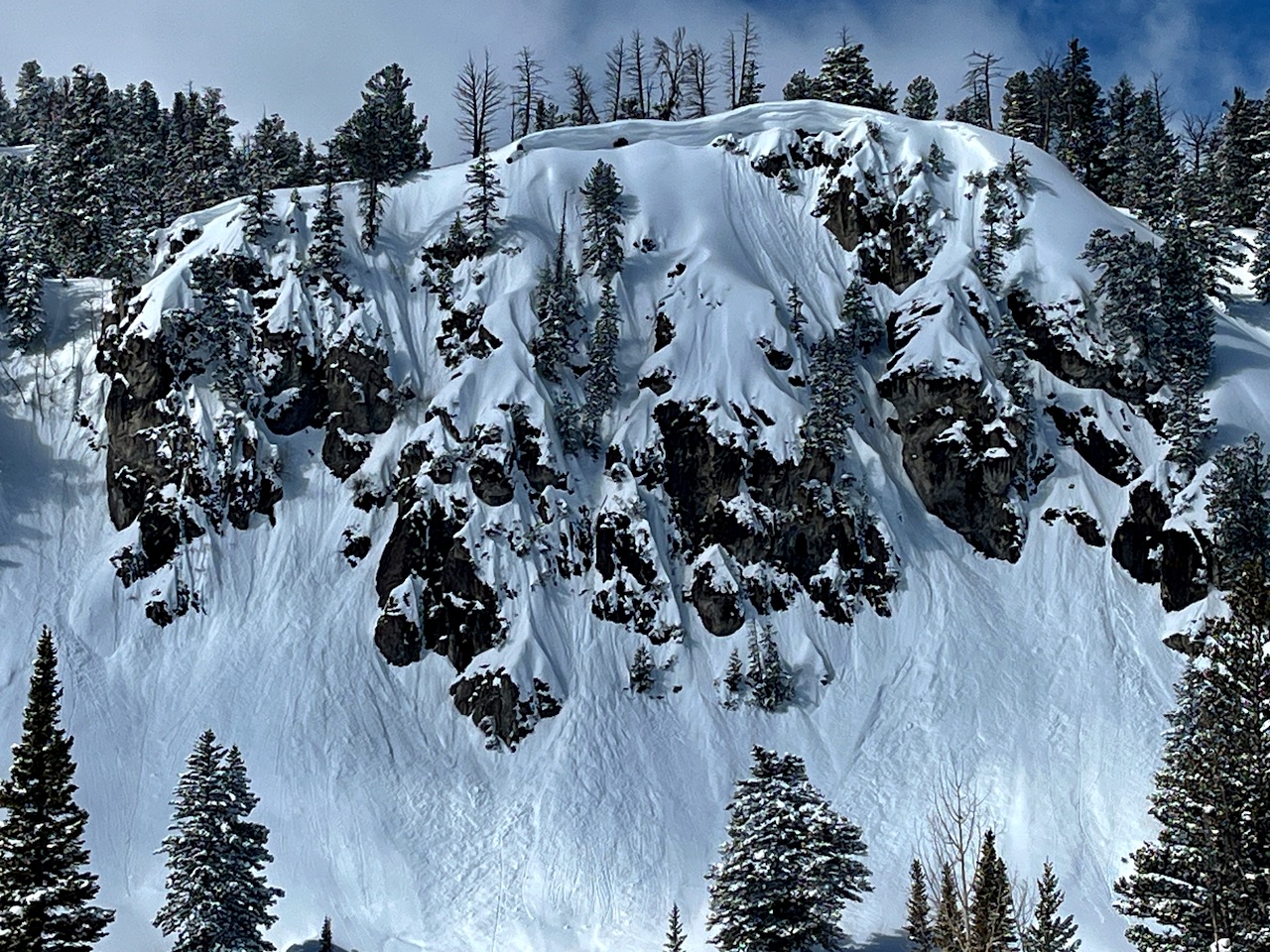
Yesterday, we could see evidence of extensive natural loose and some shallow soft slab activity from Tuesday's storm. Here is a look at the cliffs on the west side of Tony Grove Lake.
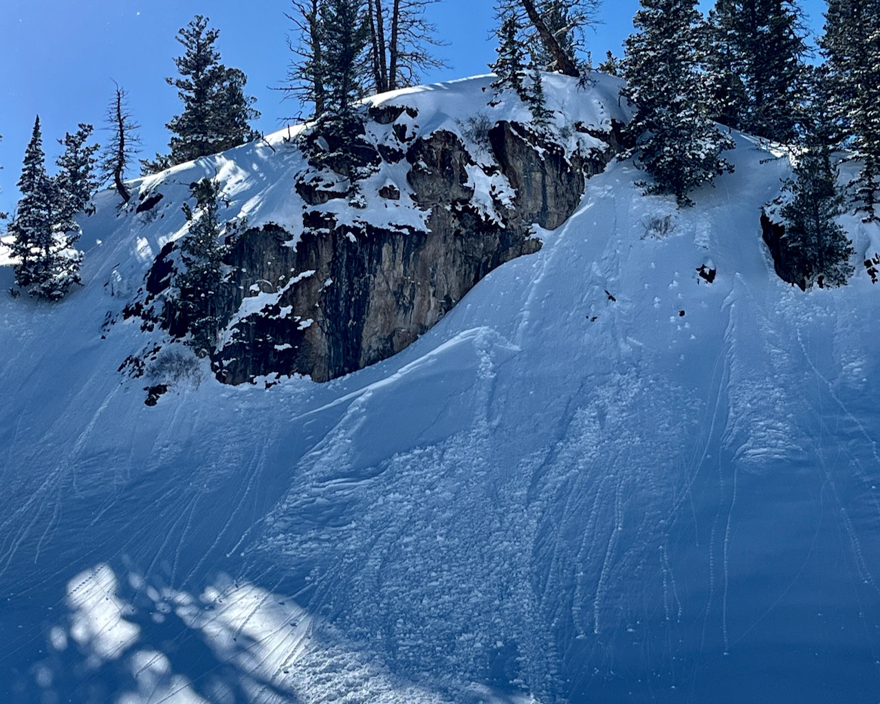
At least one positive test result in a landing zone under a cliff, with a small human-triggered wind slab popping out at around 8400' on a drifted east-northeast facing slope.
General Announcements
-National Forest Winter Recreation Travel Maps show where it's open to ride: UWCNF Logan, Ogden LRD Tony Grove, Franklin Basin CTNF Montpelier
-For all questions on forecasts, education, Know Before You Go, events, online purchases, or fundraising, call 801-365-5522.
-Remember the information you provide could save lives, especially if you see or trigger an avalanche. To report an avalanche or submit an observation from the backcountry, go HERE.
-Receive forecast region-specific text message alerts to receive messages about changing avalanche conditions, watches, and warnings. Sign up and update your preferences HERE.
-We are excited to announce the launch of our new mobile application available on both Android and IOS. Get all the information you need to plan your backcountry adventure and keep the information at the tip of your fingers while you are out. Install the Android version HERE and the IOS version HERE.

This forecast is from the U.S.D.A. Forest Service, which is solely responsible for its content. This forecast describes general avalanche conditions, and local variations always occur.