Forecast for the Logan Area Mountains

Toby Weed
Issued by Toby Weed on
Friday morning, February 7, 2025
Periods of heavy snow and drifting by strong winds from the west will elevate the avalanche danger today. The danger will rise to CONSIDERABLE on drifted upper and mid-elevation slopes steeper than 30°. Natural avalanches are possible, and people will likely trigger wind slab avalanches on slopes facing northwest through southeast.
  • Careful snowpack evaluation, cautious route-finding, and conservative decision-making are essential for safe backcountry travel today.
  • Avoid travel on or under steep drifted slopes and ridge-top cornices.
Low
Moderate
Considerable
High
Extreme
Learn how to read the forecast here
Special Announcements
The Preliminary Report for Monday's Monte Cristo avalanche fatality is HERE. Our condolences go out to the victim's friends and family and all those affected by this tragic accident. UAC staff visited the site Tuesday and a full report is forthcoming.
Weather and Snow
Moderate to heavy snowfall is apparent on Beaver Mountain's webcams this morning, and a couple inches accumulated on the lit interval board. Incessant winds from the southwest increased again last night and continue to roar across the ridges this morning. Upper elevation terrain in the Central Bear River Range picked up 5 or 6 inches of heavy snow (mostly graupel) Wednesday. The fresh snow came in on a dirty melt/freeze-crust from the heat and rain earlier in the week and greatly improved riding conditions. Yesterday, the saturated snow at mid and lower elevations was supportable, but rain last night may have softened it again. We found nice, fast shallow powder or graupel-on-crust riding conditions, especially on low angled slopes.
Heavy snow from last weekend's storm and extensive drifting by strong winds from the southwest overloaded a widespread layer of pre-existing weak snow. Avalanche conditions remain elevated in drifted terrain, and periods of heavy snow and drifting by westerly winds will cause rising danger today, especially at upper elevations on slopes facing northwest through southeast. Hard slab avalanches failing on a sugary, persistent weak layer buried 2 to 3 feet deep remain possible, and increasingly likely, softer wind slabs from today's accumulations could be pretty sensitive. Low-elevation slopes facing the south half of the compass are bare of snow or have only very shallow snow cover.
-The Tony Grove Snotel at 8400 feet reports 2 inches of new snow with .3" SWE from overnight. It's 33° F, with 68 inches of total snow. At our Card Canyon weather station at 8800 feet, it's 30° F, and there is about 2 inches of new snow, with 47 inches total.
-At the CSI Logan Peak weather station at 9700 feet, winds are blowing from the southwest 40 to 61 mph at this hour, with overnight gusts of 64 mph, and it's 27° F. On Paris Peak, at 9500 feet, it is 26° F, and the winds are blowing from the south-southwest 20 to 42 mph.

Expect snow today, heavy at times, with 3 to 7 inches of accumulation possible at 8500 feet. High temperatures will peak near 36° F this morning but drop into the upper 20s this afternoon. Winds blowing from the west 25 to 31 mph with gusts around 60 mph are expected.
There's a 20% chance of continuing snow tonight, with mostly cloudy skies, temperatures dropping to around 9° F, and winds from the west decreasing to 10 to 15 mph.
Partly sunny skies, calmer winds, and cooler temperatures are in store for the weekend.

For more information, visit the UAC weather page here: Weather - Utah Avalanche Center
For Logan-specific weather, go here: Logan Mountain Weather - Utah Avalanche Center
Recent Avalanches
  • Natural wind slab avalanches around 2 feet deep from the weekend storm were observed on many drifted easterly facing slopes in the past few days.
  • Large natural avalanches of wind-drifted snow were observed early this week in the Wellsvills and the Central Bear River Range. These, on generally east-facing slopes up high, were 1 to 3 feet deep and 100 to 800 feet wide.
  • Natural wet loose and wet slab avalanches occurred late Saturday night or early Sunday morning in Logan Canyon, with a few slides running out onto Highway 89.
  • Numerous red flags of instability were reported earlier in the week by observers, including long shooting cracks and extensive whumpfs.
Read about all avalanches and observations in the Logan Zone HERE.
Remember, the information you share about avalanches you see or trigger in the backcountry could save lives.
Ad
Avalanche Problem #1
Wind Drifted Snow
Type
Location
Likelihood
Size
Description
We advise staying clear of steep, wind-drifted slopes today. Winds out of the west picked up again significantly overnight, and there is plenty of easily transportable snow for it to drift. A couple inches of fresh snow fell overnight, and there was already a few inches of soft snow from Wednesday capping the stout crust on the snow surface during the warmth earlier in the week.
Last weekend, strong winds drifted snow into avalanche-starting zones, overloading many slopes with dense snow. Hard wind slabs are most likely to be found on the lee side of major ridges and on corniced slopes, but they were also formed by cross-loading in and around terrain features like sub-ridges, gullies, and cliff bands. Hard wind slabs sometimes allow a person to get well out on them before suddenly releasing. New, shallow, soft wind slabs of today's storm snow, around a foot deep, could be pretty sensitive.
  • Avoid rounded pillows of snow that sound or feel hollow underfoot. Wind slabs are generally much stiffer than the surrounding snow.
  • Shooting cracks and collapsing or whumpfs are clear signs of instability.
  • Many wind slabs formed on weak faceted surface snow, now a buried persistent weak layer, and instability could last for a while.
  • Some wind slab avalanches might be triggered remotely (from a distance) or from below.
Avalanche Problem #2
Persistent Weak Layer
Type
Location
Likelihood
Size
Description
Before last weekend, the Logan area mountains developed a widespread layer of weak and sugary surface snow. Last weekend's storm overloaded the weak, sugary surface snow, and it is now a buried persistent weak layer buried up to about 2 feet deep. Drifting built slabs on the weak layer, but even in sheltered terrain, soft slab avalanches will be possible to trigger.
Avalanche Problem #3
Wet Snow
Type
Location
Likelihood
Size
Description
Rain fell on low and perhaps even mid-elevation snow overnight, and wet avalanches are possible on steep slopes.
Avoid being on or under steep slopes with saturated snow. Fishers on the Logan River need to be aware of an overhead hazard. (steep slopes with saturated snow above the river)
Additional Information
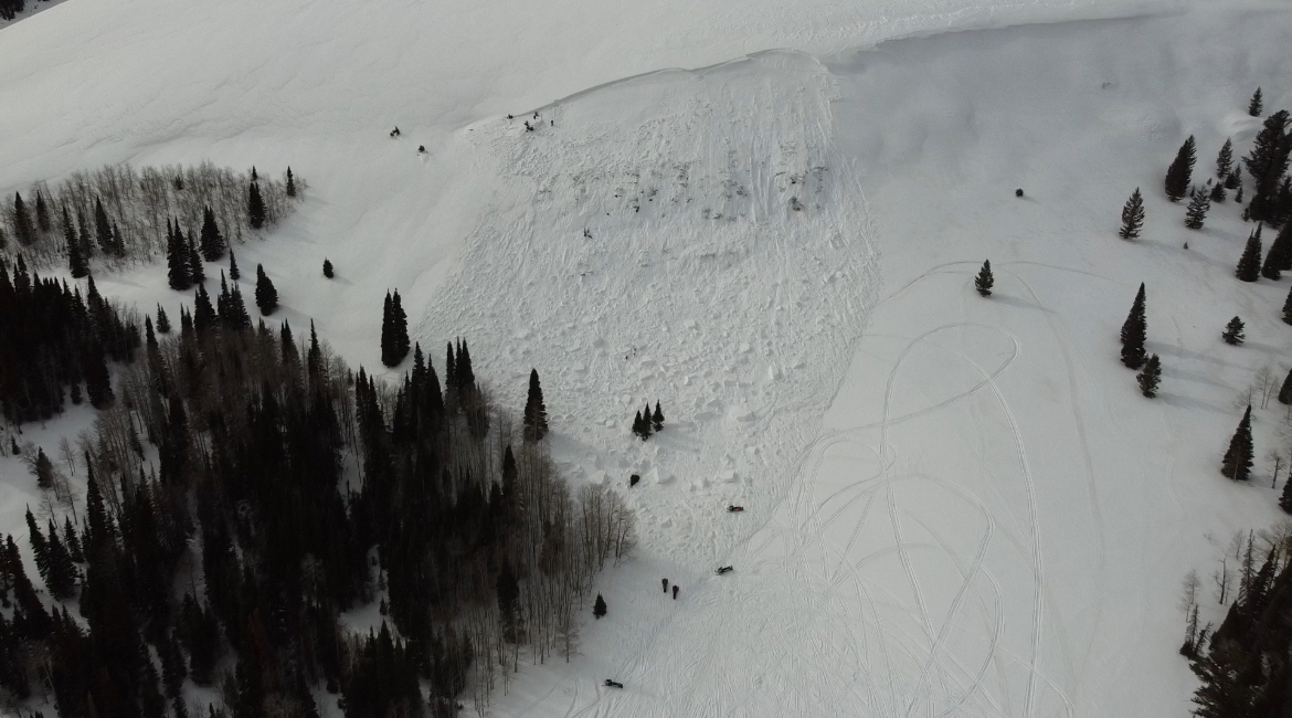
This is a look at the site of Monday's tragic fatal avalanche accident on Beer Hill in the Monte Cristo area.
General Announcements
-National Forest Winter Recreation Travel Maps show where it's open to ride: UWCNF Logan, Ogden LRD Tony Grove, Franklin Basin CTNF Montpelier
-For all questions on forecasts, education, Know Before You Go, events, online purchases, or fundraising, call 801-365-5522.
-Remember the information you provide could save lives, especially if you see or trigger an avalanche. To report an avalanche or submit an observation from the backcountry, go HERE.
-Receive forecast region-specific text message alerts to receive messages about changing avalanche conditions, watches, and warnings. Sign up and update your preferences HERE.

This forecast is from the U.S.D.A. Forest Service, which is solely responsible for its content. This forecast describes general avalanche conditions, and local variations always occur.