Get Your Ticket to the 32nd Annual Backcountry Benefit on September 11th! Support Forecasting, Awareness, and Education
Ad

Forecast for the Logan Area Mountains

Toby Weed
Issued by Toby Weed on
Monday morning, December 7, 2020
There is LOW danger in the backcountry and avalanches are unlikely. Generally safe avalanche conditions exist, but watch for unstable snow on steep drifted upper elevation slopes. Beware of very shallow, loose, sugary, and rocky early season snow conditions.
Low
Moderate
Considerable
High
Extreme
Learn how to read the forecast here
Special Announcements
The holiday season is right around the corner!! Looking for that special something for your partner?
Well, we've got an easy shopping solution for you ...Buy your gifts at our Pray for Snow online auction and support the UAC in Logan. HERE
On Saturday, Dec. 12, from 10am to noon, the UAC in Logan and USU Outdoor Programs will be hosting a FREE beacon clinic at Beaver Mountain base area.
We'll go over the basics of maintenance as well as using a beacon to find a buried avalanche victim.
Weather and Snow
Dry conditions will continue through the middle of the week, with upper elevation daytime temperatures rising into the mid thirties and dropping into the teens at night for the next few days. Later in the week, the flow aloft veers from the northwest, breaking down the valley inversions and opening the door for the passage of a couple weather systems within a weak trough of low pressure. There is a chance of some snow showers on Thursday, and perhaps even a little accumulation Friday at upper elevations in the Bear River Range.
Currently, hitting rocks or other shallowly buried obstacles presents a significant hazard in the backcountry.
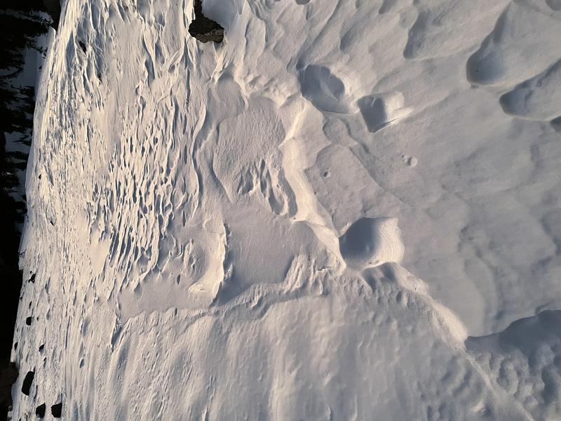
Most slopes have less than about 2' of total snow, and a steep temperature gradient is turning the shallow snow into loose sugary or faceted grains. In many places, the weak snow is easy to punch through to the rocks below.
Beware of very shallow early season snow conditions in the backcountry. The shallow snow is becoming weak and sugary or faceted, especially around rocks and down trees. After all the sun and wind this week, the snow surface is variable and inconsistent especially at upper elevations.
Recent Avalanches
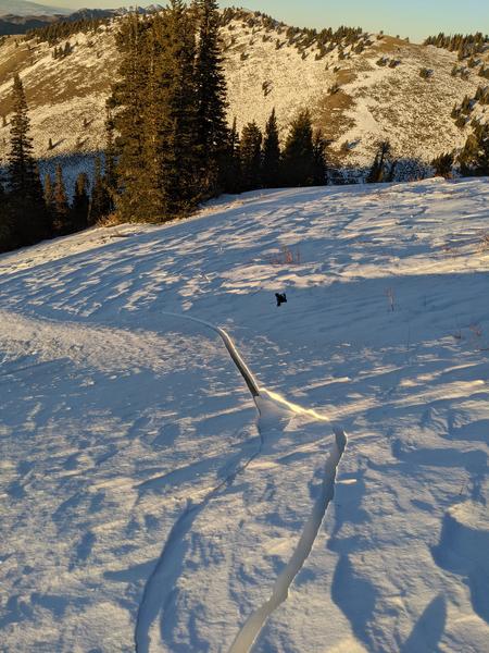
Saturday, a skier skinning up "Goal Post" avalanche path in Logan Dry Canyon triggered extensive and deep shooting cracks in the starting zone. "cracks to the ground shooting hundreds of feet in multiple directions" A stiff drift formed on well developed facets in this classic north facing deposition area, downwind from a large open lower angled fetch. Where it cracked, the slope was not very steep and the slab did not extend very far down into the avalanche path.
Shooting cracks like these are a red flag indicating unstable snow.
Ad
Avalanche Problem #1
Wind Drifted Snow
Type
Location
Likelihood
Size
Description
Potential for triggering stiff slabs of drifted snow may exist on some steep upper elevation slopes where drifts have built up on loose sugary or faceted snow, and people could trigger avalanches.
  • Even a small avalanche could be very dangerous due to shallow early season snow conditions. You do not want to get caught and carried over rocks or strained through bushes and stumps, so it's best to avoid travel on all steep drifted slopes.
Additional Information
It’s a good idea to tone it down in the early season because it’s pretty easy to get hurt in shallow snow, and it’s absolutely the worst time to do so because you could ruin your whole season.

Everybody should make time to examine and practice with your avalanche rescue equipment, and convince your backcountry partners to practice with you.
General Announcements
Visit this website with information about Responsible Winter Recreation by the Utah Office of Outdoor Recreation.
If you missed the 13th Annual Utah Snow and Avalanche Workshop, the recordings are available for purchase from the UAC Store. HERE
The Tony Grove Road is not maintained for wheeled vehicles in the winter.
EMAIL ADVISORY. If you would like to get the daily advisory by email you subscribe HERE.
Remember your information can save lives. If you see anything we should know about, please help us out by submitting snow and avalanche observations....HERE. You can also call us at 801-524-5304, email by clicking HERE, or include #utavy in your tweet or Instagram.
We will update this advisory by around 7:30 Wednesday morning.
This forecast is from the USDA Forest Service, which is solely responsible for its content. The forecast describes general avalanche conditions and local variations always occur.