31st Annual Backcountry Benefit - September 12th - Tickets Available Here!

Forecast for the Logan Area Mountains

Toby Weed
Issued by Toby Weed on
Monday morning, December 4, 2023
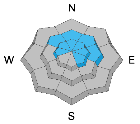
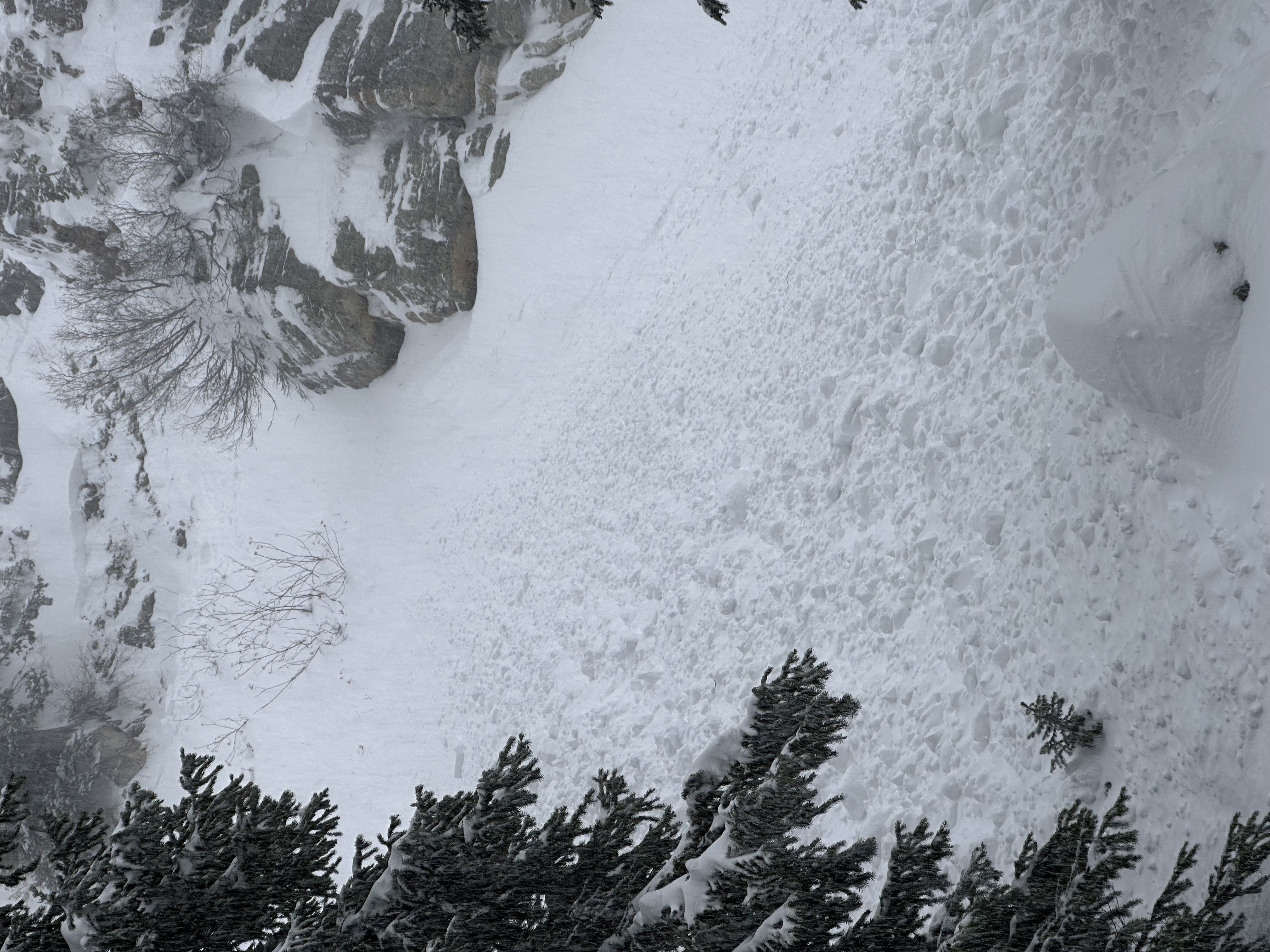
The danger is HIGH on upper-elevation slopes facing northwest through east. CONSIDERABLE danger exists on many other drifted mid and upper-elevation slopes.
The danger is MODERATE, and avalanches are possible on slopes steeper than 30 degrees at low elevations and those bare of snow before the storm. However, we expect these to stabilize pretty quickly.

People should avoid traveling on or under drifted north and east-facing slopes at upper elevations.
Low
Moderate
Considerable
High
Extreme
Learn how to read the forecast here
Special Announcements
Join the Utah Avalanche Center in Logan for the 20th Annual Pray for Snow Party and Fundraiser on Tuesday, Dec 5th, from 6:00-10:00 PM at The Cache to support avalanche forecasting, education, and awareness in northern Utah. Purchase tickets here.
The 5th Annual Avalanche Awareness Week is December 3-10. The week's goal is to save lives through activities that promote avalanche awareness, education, and safety. We have a variety of events around the state. Find an event near you.
Weather and Snow
Light snowfall continues this morning, and westerly winds moderated a bit but are still blowing and drifting snow in the mountains. Significant drifting occurred over the weekend, and the danger remains HIGH on slopes with underlying weak, sugary snow.
Today, snowfall should taper off in the morning, the sky will remain mostly cloudy, westerly winds will moderate a bit but will still blow 15 to 20 mph with gusts to around 35 mph, and 8500' temperatures will be around 32 F. It will be mostly cloudy tonight with low temperatures around 19 F, and mostly sunny tomorrow and Wednesday with high temperatures around 34 F.

The Tony Grove Snotel at 8400' reports well over 3' of snow from the storm containing a whopping 6.6" SWE. Elsewhere, about 30 inches accumulated at the new Card Canyon weather station, and a similar amount fell at Beaver Mt. West winds subsided a bit yesterday. However, they're still plenty strong enough to drift significant snow, blowing around 25 mph and gusting close to 40 mph at both Logan and Paris peaks...
Before the storm, only about 2 feet of snow covered the rocks on the highest shady slopes in the Bear River Range. Recent cold temperatures subjected the shallow snow to a significant temperature gradient, causing it to become faceted and weak. There was very little snow at mid and lower elevations, and many sunny slopes were bare.
Recent Avalanches
We received reports of natural and probably remotely triggered avalanches in the Tony Grove Area at 8200' and 7500'. All reporting parties mentioned whumpfs and other obvious signs of instability. Visibility was poor all day and very few people made it up to upper elevation avalanche terrain, with limited access yesterday, so there was probably quite a bit of unreported natural avalanche activity up high.
Go to our avalanche page to check out yesterday's reported avalanche activity.
Ad
Avalanche Problem #1
Persistent Weak Layer
Type
Location
Likelihood
Size
Description
The meager November snow in upper elevation avalanche starting zones barely covered the rocks before the weekend storm, and it is extremely weak and sugary due to its shallowness and sustained cold temperatures. Drifting snow from this weekend’s storm overloaded this weak faceted snow, and avalanches have been failing on the old sugary snow, now a persistent weak layer. Avalanches failing on a persistent weak layer could be triggered remotely, from a distance, or below. Cracking and collapsing (or whumpfs) are definite signs of instability.
Avalanche Problem #2
Wind Drifted Snow
Type
Location
Likelihood
Size
Description
Strong westerly winds drifted large quantities of fresh snow into upper-elevation avalanche-starting zones, creating thick wind slabs in exposed terrain. People should avoid thicker drifted snow on the lee side of prominent ridges and in and around terrain features like sub-ridges, gully walls, and cliff bands.
Avalanche Problem #3
New Snow
Type
Location
Likelihood
Size
Description
With warming temperatures, the new snow is denser and heavier on top. This is "inverted" or "upside-down” snow, and it’s prone to avalanching. Even on slopes bare before the storm, slabs of denser storm snow or wind-drifted snow could fail on layers within the new snow. This instability will not last long; we expect to see increasing stability today.
Additional Information
Additional Information:
It’s been a busy fall, and I’m happy to report that we’ve recently installed two new weather stations in the Logan Zone. They are both up and running, producing real-time data available to the public, and they will help us forecast mountain weather and local avalanche danger more accurately.
  • The Paris Peak Weather Station (available HERE) was installed in the northern Bear River Range near the summit of Paris Peak at around 9500 feet in elevation, northwest of Bear Lake. It measures mountain-top winds in a vast area without similar data.
  • We installed the Card Canyon Weather Station (available HERE) near Red Pine Ridge at about 8750 feet in elevation north of Logan Peak in upper Card Canyon. In addition to other weather details, this station will measure the total snow depth and its changes throughout the winter.

Taking time to pull out, check your companion rescue gear, and practice with your transceiver is essential.
General Announcements
The Tony Grove Road is not maintained for winter driving, and you will likely encounter very slick, snowy, and icy conditions if you venture up there.
Our 20th annual Pray For Snow fundraiser party will be on Tuesday night, December 5, at the Cache on Main Street in Logan. For more information and to get your tickets in advance, go to our events page.
Know Before You Go - December 6 - Utah State University, Logan. It’s Free! Please join us for a KBYG presentation hosted by Utah State University from 6:00 - 8:00 PM: Location: USU Aggie Recreation Center (ARC), 805 E 700 N, Logan, UT.
This information does not apply to developed ski areas or highways where avalanche control is normally done. This forecast is from the U.S.D.A. Forest Service, which is solely responsible for its content. This forecast describes general avalanche conditions and local variations always occur.
We will update this forecast tomorrow morning.