Join us for the 17th Annual Professional Snow and Avalanche Workshop (PROSAW) on November 4 - Purchase tickets here!

Forecast for the Logan Area Mountains

Toby Weed
Issued by Toby Weed on
Monday morning, December 11, 2023
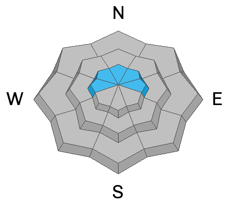
Avalanches are unlikely in most areas, and the danger is LOW. Exceptions and areas of MODERATE danger may exist in some drifted terrain at upper elevations. People could trigger small slab avalanches of wind-drifted snow on slopes steeper than 30 degrees.
Dangerous avalanches failing on a persistent weak layer are unlikely but possible in isolated rocky terrain with thin snow cover.

Use usual caution and evaluate snow and terrain carefully while traveling in drifted terrain.
Low
Moderate
Considerable
High
Extreme
Learn how to read the forecast here
Special Announcements
Join the UAC and Young Powersports in Centerville on Thursday, December 14, from 5 - 7 PM for a FREE avalanche transceiver training. Details here.
Weather and Snow
Yesterday, upper-elevation winds blew persistently from the southwest and west. Winds diminished significantly this morning, but the new Paris Peak weather station at 9500' reported many hours with average wind speeds of around 30 mph and gusts in the 40s. Light snowfall was reported yesterday and early this morning. About an inch accumulated on Beaver Mountain's lit interval snowboard. The Tony Grove Snotel at 8400' reports .5" SWE in the last 24 hours. There is 56" of total snow, and it's 26 F.

Expect mostly cloudy weather and some light snow in the mountains today, with 1 to 3 inches of accumulation possible. 8500' high temperatures will be around 28 F, and west winds will blow 5 to 10 mph.

Cloudy conditions and periods of light snow with little accumulation are expected today and tomorrow. Fairly light winds will swing around and blow from the east tonight. Seasonally cold temperatures, light east winds, and sunny conditions are expected Wednesday. High pressure is expected to dominate the weather pattern for a while and no storms are in the current forecast.

Recent Avalanches
Visit our avalanche page to check out the recent avalanche activity from the Bear River Mountains and the Wasatch Range.
Ad
Avalanche Problem #1
Wind Drifted Snow
Type
Location
Likelihood
Size
Description
In exposed terrain, recent winds from the southwest drifted snow onto steep slopes and into avalanche-starting zones.
  • Avoid stiffer, drifted snow on the lee side of prominent ridges and in and around terrain features like gullies, sub-ridges, scoops, mid-slope rollovers, and rock outcroppings or cliff bands.
  • Drifted snow is stiffer than fresh powder, and lense-shaped wind slabs might sound hollow, like a drum. Soft wind slabs could be very sensitive and easily triggered. Hard wind slabs are often more stubborn but can release suddenly like a mouse trap when people get out on them.
Avalanche Problem #2
Persistent Weak Layer
Type
Location
Likelihood
Size
Description
Dangerous avalanches failing on a persistent weak layer are increasingly unlikely as the shallow, sugary snow from November is buried and pressed into terrain anchors by a deep layer of heavy and hardening snow.
  • Avalanches failing on a persistent weak layer might still be triggered remotely, from a distance, or below.
  • Cracking and collapsing (or whumpfs) are definite signs of instability, but they may not be present when avalanches occur.
Additional Information
We went up to the Ballroom in Beaver Envy (Amazon Face) on Saturday and this is what we found,

This fall, we installed two new weather stations in the Logan Zone. The Paris Peak Weather Station (available HERE) and the Card Canyon Weather Station (available HERE)
General Announcements
  • Taking time to check your companion rescue gear and practice with your transceiver is essential. watch a short video here
  • IMPORTANT: Read Mark's blog about electromagnetic interference of avalanche transceivers HERE
  • Our 20th annual Pray For Snow fundraiser party was a huge success. Thanks for coming and showing your support!
  • We will update this forecast on Wednesday morning.
This forecast is from the U.S.D.A. Forest Service, which is solely responsible for its content. This forecast describes general avalanche conditions, and local variations always occur.