Forecast for the Logan Area Mountains

Issued by Toby Weed on
Tuesday morning, January 5, 2021
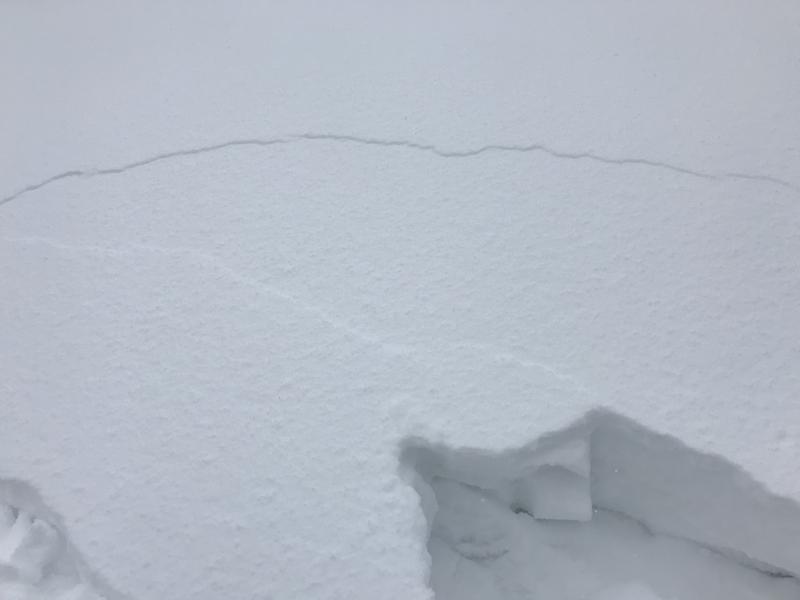
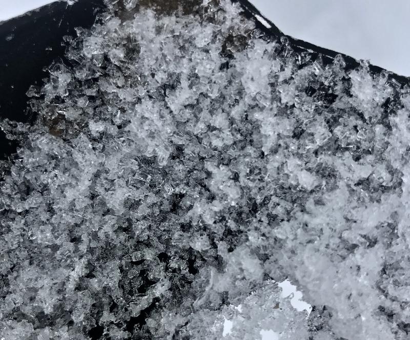
Heavy snow and drifting from strong westerly winds overnight overloaded slopes with widespread buried persistent weak layers. The avalanche danger is HIGH, and dangerous avalanche conditions exist at all elevations. Human triggered and natural avalanches are most likely on drifted upper and mid elevation slopes facing northwest through southeast, but possible in sheltered and lower elevation terrain. Avalanches could be triggered remotely or from a distance.
Avoid travel in avalanche terrain today. Stay off, away from, and well out from under all drifted slopes steeper than about 30 degrees.

Low
Moderate
Considerable
High
Extreme
Learn how to read the forecast here
Avalanche Warning
IN EFFECT FROM 6 AM MST THIS MORNING TO 6 AM MST WEDNESDAY
FOR THE MOUNTAINS OF FAR NORTHERN UTAH AND SOUTHEAST IDAHO INCLUDING THE BEAR RIVER RANGE AND THE MOUNTAINS NEAR LOGAN AND BEAR LAKE
THE AVALANCHE DANGER FOR THE WARNING AREA IS HIGH TODAY.
HEAVY SNOW AND DRIFTING FROM STRONG WIND HAS CREATED WIDESPREAD AREAS OF UNSTABLE SNOW. BOTH HUMAN TRIGGERED AND NATURAL AVALANCHES ARE LIKELY. STAY OFF OF AND OUT FROM UNDER SLOPES STEEPER THAN 30 DEGREES.
--Avalanche Watch
Special Announcements
We are offering a Backcountry 101 Avalanche education class in Logan on Jan 21 and 22. . Details and registration here.
Check out our new and relevant Blog featuring Paige and Greg discussing Danger Ratings and Persistent Weak Layers....HERE
Thanks to the generous support of our local resorts, Ski Utah, and Backcountry, discount lift tickets are now available. Support the UAC while you ski at the resorts this season. Tickets are available here.
Weather and Snow
It looks like 7 to 9 inches of medium density new snow fell overnight in the Bear River Range and strong westerly winds drifted snow onto slopes with widespread preexisting weak layers. Beaver Mountain is reporting 7", and I'm reading 9" with one inch of Snow Water Equivalent or SWE at the 8400' TGLU1 Snotel in the Central Bear River Range. The heavy new snow and drifting from strong westerly winds overloaded widespread preexisting sugary weak snow and has created HIGH danger in the backcountry.
Snow will taper off this morning, temperatures will drop into the teens, and a northwest breeze will create wind chill values around 0°F. Looks like a break in the weather, a brief period of high pressure Wednesday, and then another modest storm, with more light snow possible Thursday.
Recent Avalanches
On Saturday, a snowboard rider triggered a small avalanche across Beaver Creek Canyon from the backside parking spot. The small slab avalanche was on a very steep drifted lower elevation slope, and indicates potential for a widespread problem with buried persistent weak layers as the season progresses..
Avalanche Problem #1
Persistent Weak Layer
Type

Location

Likelihood

Size

Description
The buried persistent weak layer problem involving sugary faceted snow is a very dangerous and notoriously tricky avalanche problem, and it is responsible for most fatalities, injuries, and close calls in the Logan Zone.
Sunday, I triggered subtle collapses and extensive cracking, and several 1'-deep frowns, 20 to 30' wide and 10 to 20' above me on a 25 degree slope on the backside of Beaver Mt., on an east facing mid-elevation slope. A developing and now more cohesive soft slab was failing on loose sugary faceted snow above a stout crust that was on the snow surface in November.

Cracking like this is a red flag inticating unstable snow.
I found these nice large faceted grains or depth hoar buried near the ground in Steep Hollow yesterday.

- Avalanches failing on a persistent weak layer can be very sensitive, and they might be triggered remotely, from a distance, or worse from below!
Avalanche Problem #2
Wind Drifted Snow
Type

Location

Likelihood

Size

Description
Fresh drifts formed on weak layers that have developed on the snow surface or preserved under about an inch of new snow. Soft drifts of new snow, up to about a 2 feet deep, could be quite sensitive, and a smaller avalanche overrunning a slope with poor snow structure could create a much larger avalanche. Old, harder wind slabs are fairly widespread at upper elevations near ridge tops and in and around terrain features like gullies, cliff bands, and sub ridges. People could trigger 1 to 3-foot-thick slab avalanches of wind drifted snow on steep slopes, especially where drifts formed on weak, sugary, or faceted snow.
- Avalanches of wind drifted snow could be triggered remotely or from a distance.
- Harder wind slabs may allow people to get out on them before releasing.
Additional Information
Everybody should make time to examine and practice with your avalanche rescue equipment, and convince your backcountry partners to practice with you. Watch our companion rescue video HERE
My tip for avoiding avalanches in the backcountry is to keep your slope angles low. Avoid and stay out from under slopes steeper than about 30 degrees. Get a tool to measure slope angle and practice with it in the backcountry. Watch the video HERE.
Paige shows what we are talking about when we mention faceted snow in our forecasts. Watch the video HERE
General Announcements
Visit this website with information about Responsible Winter Recreation by the Utah Office of Outdoor Recreation.
We've kicked off Season 4 of the UAC podcast with a Conversation with American Avalanche Institute owner Sarah Carpenter. You can stream it HERE or wherever you get your favorite podcasts.
The Tony Grove Road is not maintained for wheeled vehicles in the winter.
EMAIL ADVISORY. If you would like to get the daily advisory by email you subscribe HERE.
Remember your information can save lives. If you see anything we should know about, please help us out by submitting snow and avalanche observations....HERE. You can also call us at 801-524-5304, email by clicking HERE, or include #utavy in your tweet or Instagram.
I will update this forecast by around 7:30 tomorrow morning.
This forecast is from the USDA Forest Service, which is solely responsible for its content. The forecast describes general avalanche conditions and local variations always occur.