Get Your Ticket to the 32nd Annual Backcountry Benefit on September 11th! Support Forecasting, Awareness, and Education
Ad

Forecast for the Logan Area Mountains

Toby Weed
Issued by Toby Weed on
Sunday morning, January 3, 2021
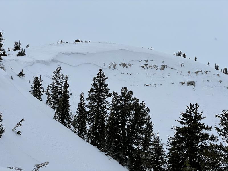
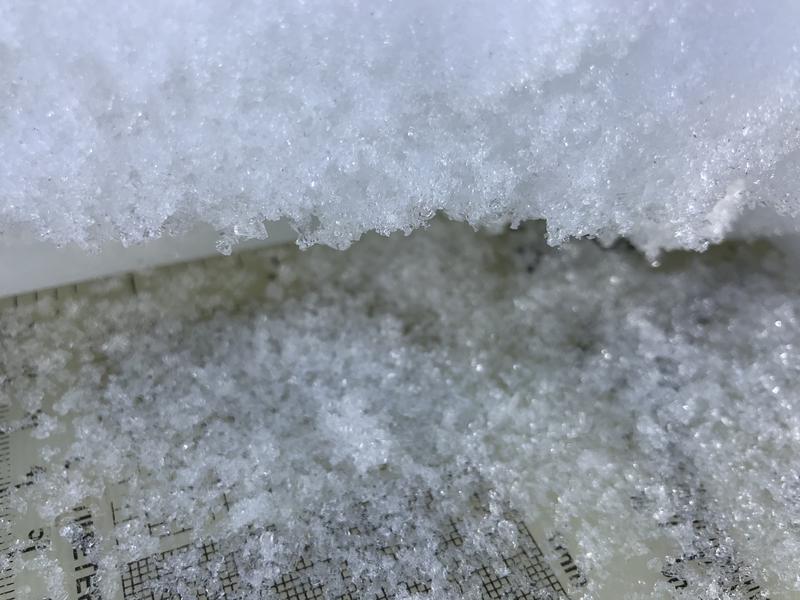
Heightened avalanche conditions exist at mid and upper elevations in the backcountry. People could trigger dangerous slab avalanches failing on a sugary persistent weak layer.
Drifting of today's new snow will cause rising avalanche danger, especially in the northern part of the zone where more snow is forecast. Dangerous avalanche conditions could develop in some areas, and the danger may become CONSIDERABLE later today at upper elevations on drifted slopes facing northwest through southeast. Avalanches could be triggered remotely or from a distance.
  • Shallow snow coverage dictates careful travel, and hitting shallowly buried rocks still presents serious risk in the backcountry.
  • Cracking and collapsing indicate unstable snow.
  • Evaluate snow and terrain carefully, and continue to stay off and out from under steep drifted slopes.
Low
Moderate
Considerable
High
Extreme
Learn how to read the forecast here
Special Announcements
We are offering a Backcountry 101 Avalanche education class in Logan on Jan 21 and 22. . Details and registration here.
Check out our new and relevant Blog featuring Paige and Greg discussing Danger Ratings and Persistent Weak Layers....HERE
Thanks to the generous support of our local resorts, Ski Utah, and Backcountry, discount lift tickets are now available. Support the UAC while you ski at the resorts this season. Tickets are available here.
Weather and Snow
Remember to pack the goggles today, it's looking like a powder day and it's already snowing this morning. You'll find about an inch of new snow from overnight, and lower angled slopes in sheltered terrain offer nice fast conditions. In many areas, the skiff of fresh snow is capping glittering feathers of surface hoar or small-grained sugary snow and thin radiation crusts. On steeper slopes you will still sink into the underlying sugary older snow, and you could trigger dangerous avalanches on steep drifted slopes. Snow coverage is still very shallow in the Logan Zone, and the snow that was on the ground in November and early December is very loose and sugary. In many places you still sink all the way to the ground when you hop off your sled or come out of your skis.
We noted less whumpfing, and gradual stabilization of the snow is occurring in Steep Hollow, but our tests show that people could still trigger dangerous avalanches.

Expect snow in the mountains today, with 3 to 7 inches of accumulation. 8500' high temperatures are expected to be in the mid twenties, with west winds, and wind chill values around -4° F. A potentially stronger system is expected Monday night and Tuesday, and with luck, 7 to 11 inches of snow could accumulate on upper elevation slopes.
Recent Avalanches
We noticed that a snowboard rider triggered a small avalanche across Beaver Creek Canyon from the backside parking spot. The small slab avalanche was on a very steep drifted lower elevation slope, and indicates potential for a widespread problem with buried persistent weak layers as the season progresses..
A couple large natural avalanches occurred with last weekend's small but windy storm.
  • A large natural avalanche of wind drifted snow, 2 feet deep and at least 500' wide, was spotted Tuesday on the corniced east ridge of Chicken Hill in Bunch Grass Canyon.

This broad natural avalanche in Grandfather Cornice on Cornice Ridge occurred at about 9200' on a northeast facing slope.
Ad
Avalanche Problem #1
Persistent Weak Layer
Type
Location
Likelihood
Size
Description
Many slopes in the region are plagued by layers of weak faceted snow formed during the prolonged November dry spell. The persistent weak layer problem is a very dangerous and notoriously tricky avalanche problem, and it is responsible for most fatalities, injuries, and close calls in the Logan Zone. Avalanches failing on a persistent weak layer can be very sensitive, and they might be triggered remotely, from a distance, or worse from below!
Avalanche Problem #2
Wind Drifted Snow
Type
Location
Likelihood
Size
Description
Drifting of today's new snow could cause the avalanche danger to rise in exposed terrain. Southwest winds picked up again early this morning, and there is already some soft snow to drift around. Fresh drifts could form on weak layers that have developed on the snow surface or preserved under about an inch of new snow. Soft drifts of new snow, up to about a foot deep, could be quite sensitive, and a smaller avalanche overrunning a slope with poor snow structure could create a much larger avalanche.
Old, harder wind slabs are fairly widespread at upper elevations near ridge tops and in and around terrain features like gullies, cliff bands, and sub ridges. People could trigger 1 to 3 feet thick slab avalanches of wind drifted snow on steep slopes, especially where drifts formed on weak, sugary, or faceted snow. Some avalanches of wind drifted snow could still be triggered remotely or from a distance.
  • Harder wind slabs may allow people to get out on them before releasing.
  • Even a small avalanche could be very dangerous due to shallow early season snow conditions.
Additional Information
Everybody should make time to examine and practice with your avalanche rescue equipment, and convince your backcountry partners to practice with you. Watch our companion rescue video HERE
My tip for avoiding avalanches in the backcountry is to keep your slope angles low. Avoid and stay out from under slopes steeper than about 30 degrees. Get a tool to measure slope angle and practice with it in the backcountry. Watch the video HERE.
Paige shows what we are talking about when we mention faceted snow in our forecasts. Watch the video HERE
General Announcements
Visit this website with information about Responsible Winter Recreation by the Utah Office of Outdoor Recreation.
We've kicked off Season 4 of the UAC podcast with a Conversation with American Avalanche Institute owner Sarah Carpenter. You can stream it HERE or wherever you get your favorite podcasts.
The Tony Grove Road is not maintained for wheeled vehicles in the winter.
EMAIL ADVISORY. If you would like to get the daily advisory by email you subscribe HERE.
Remember your information can save lives. If you see anything we should know about, please help us out by submitting snow and avalanche observations....HERE. You can also call us at 801-524-5304, email by clicking HERE, or include #utavy in your tweet or Instagram.
I will update this forecast by around 7:30 tomorrow morning.
This forecast is from the USDA Forest Service, which is solely responsible for its content. The forecast describes general avalanche conditions and local variations always occur.