Forecast for the Logan Area Mountains

Toby Weed
Issued by Toby Weed for
Thursday, January 26, 2023
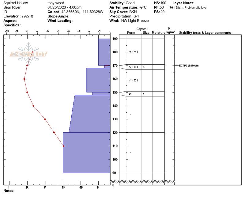
There is MODERATE avalanche danger in drifted upper elevation terrain. The snow is generally stable where not effected by the wind, large avalanches are unlikely, and the danger remains LOW at mid and lower elevations.
Expect rising avalanche danger and dangerous conditions to develop in the backcountry tomorrow with heavy snowfall and drifting from west winds.
  • People should evaluate snow and terrain carefully if they venture into drifted terrain.
Low
Moderate
Considerable
High
Extreme
Learn how to read the forecast here
Weather and Snow
Nice powder riding conditions can still be found in many places and at all elevations in the backcountry. Large avalanches are unlikely today, but people could trigger shallow slab avalanches of wind drifted snow, and small loose avalanches or sluffs are possible in very steep terrain. As always, keep an eye on your partners, travel one at a time in and below terrain steeper than 30°, and have a plan if an avalanche were to happen.
The Tony Grove Snotel at 8400' reports 17° F and 81"of total snow. The CSI Logan Peak weather station at 9700' is showing winds blowing from the northwest around 22 mph.
Today will be mostly cloudy with a good chance for some snow showers. High temperatures at 8500' are expected to be about 17° F and 10 to 17 mph winds blowing from the northwest will create wind chill values around -4° F.
Snow is likely tonight, with 2 to 4 inches of accumulation possible at upper elevations. Expect temperatures to rise to around 19° F, 15 to 20 mph west winds, with higher gusts, and wind chill values around -4° F.
Tomorrow will be stormy with 8 to 12 inches of accumulation possible, high temperatures around 20° F and 25 mph winds blowing from the west-southwest with gusts around 50 mph. Heavy snowfall and drifting will continue tomorrow night, with an additional 5 to 9 inches possible.
It looks like snowy weather in the mountains will continue through this weekend.
Recent Avalanches
Some loose wet avalanches occurred in the middle of the day in Wood Camp on Monday...HERE. Otherwise in the Logan Zone, only a few small avalanches of wind drifted snow were reported in the last week or so.
Find a list of all observations & avalanches from across Utah HERE.
Ad
Avalanche Problem #1
Wind Drifted Snow
Type
Location
Likelihood
Size
Description
People might trigger shallow soft or harder wind slab avalanches in drifted terrain. Mostly a problem limited to upper elevations, but sensitive wind slabs could be found down lower as well.
  • Moderate but sustained winds from the northwest enlarged cornices and built new drifts and fresh wind slabs overnight and in the past few days. Some of these may have formed on weakening surface snow and could remain pretty sensitive.
  • Avoid corniced slopes and stiffer drifts on steep slopes near ridges and in and around terrain features like under cliff bands, sub-ridges, mid-slope break-overs, and gully walls..
  • Even a small wind slab avalanche can have large consequences if you get swept into trees or other terrain traps.
Avalanche Problem #2
Normal Caution
Type
Location
Likelihood
Size
Description
In general in the Logan zone, the snowpack is deep and stable. Large avalanches are unlikely, but people still need to pay attention and to follow basic avalanche safety protocols.
  • Loose avalanches entraining light surface snow are possible on very steep slopes at all elevations, and on sustained slopes these can pick up speed and volume pretty quickly. Stay out from under your partners and other parties and avoid very steep terrain where you could be swept into trees, gullies or other terrain traps.
  • Today the danger is Low on mid and lower elevation slopes, but remember Low danger does not mean No danger. If you are in avalanche terrain, avalanches are always possible.
  • There are still isolated areas with poor snow structure, primarily where the snow is shallower, where dangerous deep slab avalanches failing on a persistent weak layer are unlikely, but still a possibility.
Additional Information
From what I could see in the field Wednesday, significant loading from Friday's forecasted winter storm will likely cause dangerous avalanche conditions. At least in some areas, Wednesday's super light powder buried and preserved a layer of weak surface snow. (12-25-23 photos from east facing, 8000', in Squirrel Hollow, Emigration Summit ID)
General Announcements
  • Please submit your observations from the backcountry HERE.
  • For a list of avalanche classes from the Utah Avalanche Center go HERE
  • For information on where you can ride your sled or snowbike, check out this map of the winter travel plan for the Logan and Ogden Ranger Districts HERE, and a close up of the Tony Grove and Franklin Basin Areas HERE.
This forecast is from the U.S.D.A. Forest Service, which is solely responsible for its content. This forecast describes general avalanche conditions and local variations always occur.