AVALANCHE WARNING!! Tap for info
UDOT PLANNED AVALANCHE CLOSURES!!

Forecast for the Logan Area Mountains

Toby Weed
Issued by Toby Weed on
Friday morning, January 24, 2025
The snow is stable on most slopes, and the overall avalanche danger is LOW in the backcountry. However, areas with heightened avalanche conditions exist on drifted upper elevation slopes steeper than 30°, where recently formed wind slabs are easy to identify and avoid. Shooting cracks in wind-drifted snow indicate instability.
Evaluate snow and terrain carefully, and reconsider your route if it takes you onto or under steep slopes with recent deposits of wind-drifted snow.
Low
Moderate
Considerable
High
Extreme
Learn how to read the forecast here
Special Announcements
Urgent battery replacement is required for anyone who received batteries from one of our participating "Batteries for Beacons" shops. Please review the "Batteries for Beacons" replacement notice on our blog. HERE
Batteries distributed through our "Batteries for Beacons" program this year are of inadequate length.
Weather and Snow
Temperatures are quite a bit warmer in the mountains this morning, with 23° F at 5:00 am at the Tony Grove Snotel and 20° F at the top of Card Canyon. Winds blowing from the southwest increased again overnight, but with the incessant winds already this week, they will not find much snow soft enough to drift. Despite widespread wind-jacked snow in exposed terrain across the Logan Zone, we've found nice recrystallized powder in sheltered terrain and pockets of softer snow in open areas where the snow surface is rough-looking, scalloped, or dimpled like an orange peel.
With the very cold, clear nights this week, a severe temperature gradient caused significant faceting of the snow on and near the surface on slopes facing all directions. This weak, sugary snow, in many cases capping or sandwiched between thin crusts, will likely create a troublesome persistent weak layer(s) when future snow accumulates.

-The Tony Grove Snotel at 8400 feet reports 23° F, with 56 inches of total snow. -At the Card Canyon weather station at 8800 feet, it's 20° F and there is 43.5 inches of total snow.
-At the CSI Logan Peak weather station at 9700 feet, winds are blowing from the southwest around 40 mph with gusts to 55 mph, and it's 14° F, with a windchill of -9° F. -On Paris Peak at 9500 feet, it is 12° F, the winds are blowing from the southwest 30 to 40 mph, and the windchill is -10° F.

A Pacific Northwest storm system will move into the Great Basin today, bringing a cold front into northern Utah that will bring snow late Friday into Saturday.
NWS Point Fx for the Naomi Peak Area: Today: 40% chance of snow after 8:00 am. Mostly cloudy, with a high near 22° F. Wind chill values as low as 2° F. West wind 11 to 14 mph. Total daytime snow accumulation of around an inch possible. Tonight: Mostly cloudy, with a low around 6° F. Wind chill values as low as -10° F. West wind 8 to 15 mph becoming east after midnight. Winds could gust as high as 30 mph. Saturday: A 40% chance of snow. Mostly cloudy, with a high near 14° F. Wind chill values as low as -14° F. Breezy, with an east wind 18 to 23 mph, with gusts as high as 40 mph. New snow accumulation of less than a half inch possible.
Clear, cold, and dry weather is expected in Northern Utah through most of next week...

For more information, visit the UAC weather page here: Weather - Utah Avalanche Center
For Logan-specific weather, go here: Logan Mountain Weather - Utah Avalanche Center
Recent Avalanches
  • There were no recent avalanches reported locally. Read about all avalanches and observations in the Logan Zone HERE.
  • ***Remember, the information you share about avalanches you see or trigger in the backcountry could save lives.
Ad
Avalanche Problem #1
Wind Drifted Snow
Type
Location
Likelihood
Size
Description
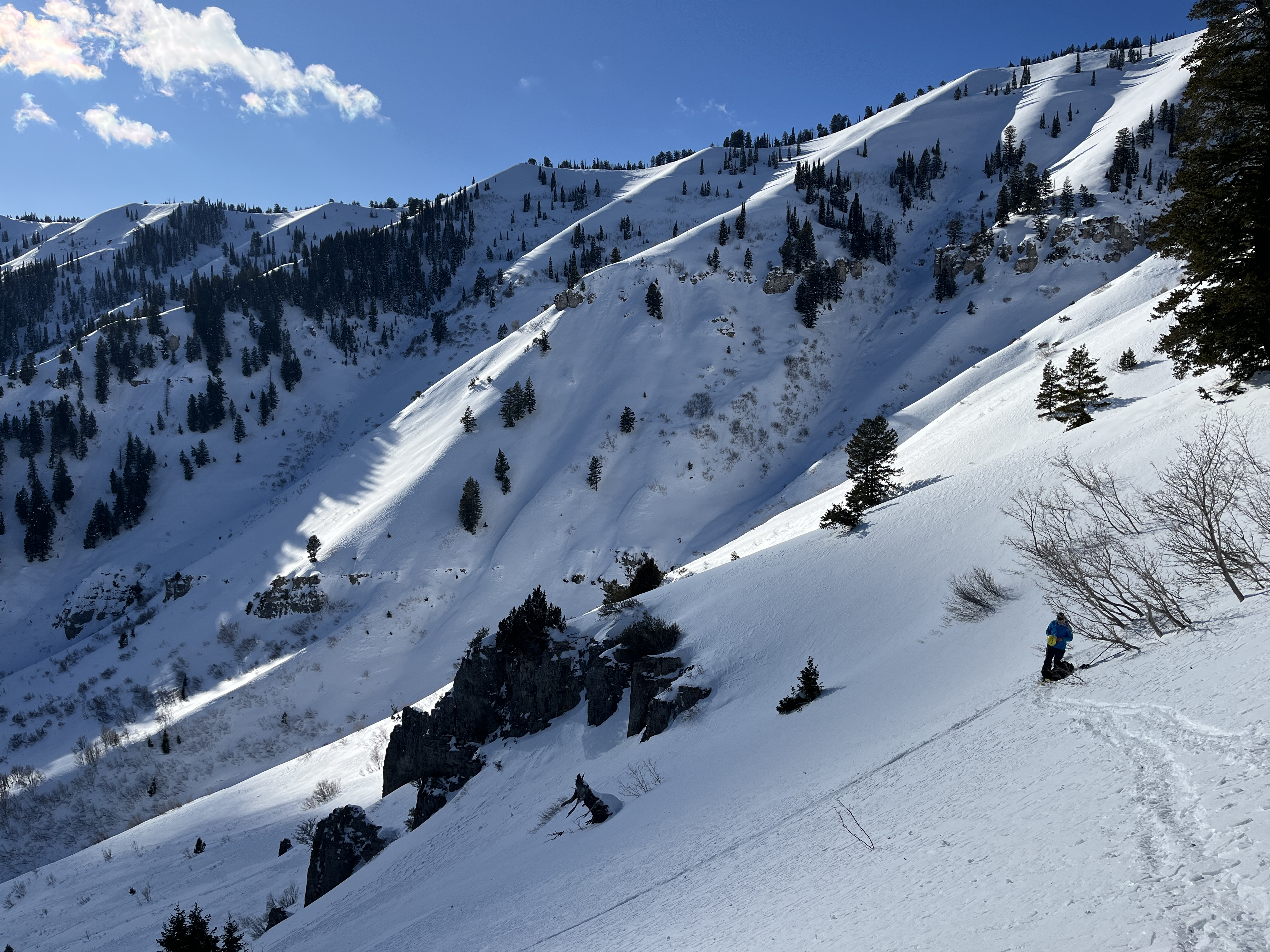
Recent drifting built stiff wind slabs on weak, sugary (or faceted) surface snow in exposed terrain, and it is possible to trigger 1 to 2 feet thick slab avalanches of wind-drifted snow on steep drifted slopes. Thick wind deposits, drifts, and wind slabs are easy to identify, and you should avoid them on slopes steeper than 30°. Wind-drifted snow is generally stiffer than the surrounding snow, and wind slabs can produce hollow drum-like sounds.
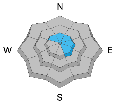
  • Avalanches of wind-drifted snow are most likely on the lee side of major ridges, especially on slopes capped by cornices. Fresh wind slabs may be found in and around terrain features like cliff bands, sub-ridges, gullies, and scoops.
  • Many stiff and thick wind slabs built up on preexisting weak surface snow and some might be quite sensitive and easy to trigger. On the other hand, hard wind slabs often allow people to get well out on them before releasing suddenly, like a giant mouse trap.
  • Watch for shooting cracks as an obvious sign of instability. Some wind slab avalanches could be triggered remotely.

While the snow is stable on most slopes, a dormant, persistent weak layer near the ground is still a potential problem in isolated or outlying terrain. Recent drifting probably overloaded slopes with poor snow structure, and although unlikely, isolated hard slab avalanches, breaking 2 to 4 feet deep on a persistent weak layer near the ground are possible, and the consequences could be severe. Deep hard slab avalanches are possible in extreme mountain terrain, and rocky, windswept slopes in northerly facing terrain with thin snow cover are suspect.
Isolated hard slab avalanches might be triggered from a "sweet spot" or a shallower part of the slab. (see Bruce Jamieson's YouTube video below)
Additional Information
We went up to Wood Camp on Wednesday and found variable snow conditions, with some recrystallized powder, crust/facet sandwiches, and plenty of wind-jacked snow. see our observation
Recent strong winds created variable snow conditions across the Logan Zone, especially on open slopes.
Check out this video by Bruce Jamieson about triggering a persistent slab avalanche from a thin spot: Although unlikely this weekend, human-triggered avalanches failing on a buried persistent weak layer remain possible in the Logan Zone.
General Announcements
-National Forest Winter Recreation Travel Maps show where it's open to ride: UWCNF Logan, Ogden LRD Tony Grove, Franklin Basin CTNF Montpelier
-For all questions on forecasts, education, Know Before You Go, events, online purchases, or fundraising, call 801-365-5522.
-Remember the information you provide could save lives, especially if you see or trigger an avalanche. To report an avalanche or submit an observation from the backcountry, go HERE.
-Receive forecast region-specific text message alerts to receive messages about changing avalanche conditions, watches, and warnings. Sign up and update your preferences HERE.

This forecast is from the U.S.D.A. Forest Service, which is solely responsible for its content. This forecast describes general avalanche conditions, and local variations always occur.