Forecast for the Logan Area Mountains

Issued by Toby Weed on
Wednesday morning, January 22, 2020
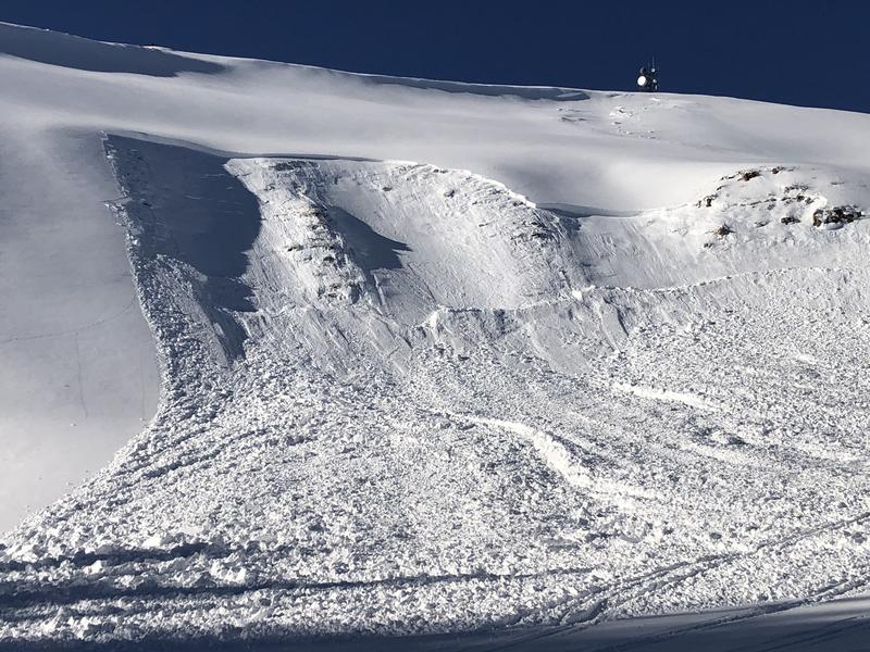
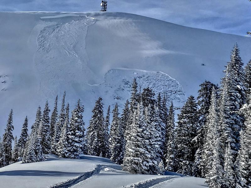
Heightened avalanche conditions and MODERATE danger exist in the backcountry. On upper and some mid elevation elevation slopes, people could trigger dangerous avalanches failing on a deeply buried persistent weak layer. Shallow avalanches of fresh wind drifted snow are possible in exposed upper elevation terrain. A little rain fell overnight at low elevations, and there is some potential for loose wet avalanches on steep slopes with saturated snow.
- Evaluate snow and terrain carefully.

Low
Moderate
Considerable
High
Extreme
Learn how to read the forecast here
Special Announcements
We are very sad to report an avalanche fatality that happened Saturday above Farmington Canyon. A 18 year old, male snowmobiler was caught, fully buried and killed. Preliminary info available HERE. We will have a full report available in the coming days. Our deepest condolences go out to the friends, family, rescuers, and everyone affected by this tragic accident.
Weather and Snow
It's 26°F at the 8400' Tony Grove Snotel this morning, and there is 3 inches of new snow from overnight with 0.5" Snow Water Equivalent. There's 80 inches of total snow , containing 126% of normal SWE. West and northwest winds have been fairly consistent overnight at the CSI Logan Peak weather station. They are currently blowing from the northwest around 20 mph, with gusts in the 40s, and it's 20°F at 9700'.
A few inches of fresh snow will refresh riding conditions in the backcountry today. Shallow, soft drifts of fresh snow may be sensitive to human triggering in some exposed upper elevation terrain. Light rain fell on low elevation slopes last night, it may have saturated the surface snow and created potential for wet avalanches on steep slopes.
It is snowing in the mountains today, with 1 to 3 inches of accumulation possible. 8500' temperatures will fall to around 22°F, and it will be rather windy with 21 to 26 mph west-northwest winds. It will be mostly cloudy tonight, with temperatures rising to near 26°F. West-northwest wind will blow 13 to 16 mph. Snow showers will resume tomorrow morning, with 1 to 3 inches possible. High temperatures will be around 29°F, with 14 mph west wind. High pressure aloft will shift east and bring dry and stable conditions to the area late in the week.
Recent Avalanches
Sunday, a solo skier triggered and was caught and carried by a huge avalanche in Miller Bowl near Tony Grove Lake. Luckily, the skier was spit out the flank at the bottom, just as the very deep pile of debris came to a stop. The avalanche on a repeater path at about 8700' was 4 to 5 feet deep and about 350 feet wide. It failed on a deeply buried sugary persistent weak layer near the ground with a loud thunderous roar, and took the skier under the snow for a harrowing spin-cycle ride. The very lucky skier lost both skis and ski poles, but is happy and grateful to have walked out alive.
A large natural or perhaps remote triggered avalanche was observed in the Fairgrounds on the east side of Logan Peak Sunday, 1-19-2020. There were no visible tracks in the area when it was first spotted.

A large hard slab avalanche was observed last Wednesday morning in the Rodeo Grounds on the east side of Logan Peak. It may have been remote triggered from the ridge as sled tracks were also observed. The large avalanche failed on sugary faceted snow near the ground.

Avalanche Problem #1
Persistent Weak Layer
Type

Location

Likelihood

Size

Description
Human triggered avalanches failing on a buried persistent weak layer are possible on upper and some mid elevation slopes. Apparently, some avalanches can step down into buried persistent weak layers, involve large volumes of snow, and be quite dangerous and destructive. The cold weather Christmas week created sugary weak surface snow in many areas, in others a layer of surface hoar feathers was buried by the New Years Storm. Recent activity in the zone shows that additional weight from tons of recent snow and significant drifting last week was enough to reactivate the deeply buried October persistent weak layer on some slopes. You can still find this weak sugary basal layer lurking on upper elevation slopes facing northwest, north and east.
- Some avalanches might be triggered remotely, from a distance or below.
- Smaller avalanches overrunning a slope with buried persistent weak layers could step down into old snow and initiate a much larger avalanche.
-
Sugary, faceted snow from a buried weak layer on a west facing slope at about 7000' (1-19-2020)
Avalanche Problem #2
Wind Drifted Snow
Type

Location

Likelihood

Size

Description
Overnight winds from the west-northwest moved the fresh snow around and created shallow drifts on upper elevation slopes that may be sensitive to human triggering today.
- Watch for and avoid stiffer drifted snow near ridge lines and in and around terrain features like cliff bands, scoops, gully walls, and sub-ridges.
- Avoid ridge top cornices, which can break much further back than expected and start avalanches on slopes below.
Avalanche Problem #3
Wet Snow
Type

Location

Likelihood

Size

Description
A bit of rain fell on lower elevation slopes last night, and loose wet avalanches are possible on steep slopes with saturated snow.
General Announcements
New UAC Podcast - An Avalanche Forecaster, a Meteorologist, and an Economist Walk Into a Bar..... HERE
The anual CROWBAR backcountry ski race will be on Saturday, February 8. The unique and classic backcountry race will be held at the Swan Flat/Garden City Trailhead in upper Logan Canyon. There are four divisions (Junior, Recreation, Heavy Metal & Race) with different climbs, descents, and technical booters. Participants must carry avalanche rescue gear (beacon, shovel, probe) and can use alpine touring gear, telemark skis, or splitboards. Register on UltraSignup, or sign up to volunteer at this year's race!
Thanks to the generous support of our Utah ski resorts and Ski Utah, we have discount lift tickets available. All proceeds from these go towards paying for avalanche forecasting and education! Get your tickets HERE.
EMAIL ADVISORY. If you would like to get the daily advisory by email you subscribe HERE.
Remember your information can save lives. If you see anything we should know about, please help us out by submitting snow and avalanche observations....HERE. You can also call us at 801-524-5304, email by clicking HERE, or include #utavy in your tweet or Instagram.
This forecast is from the USDA Forest Service, which is solely responsible for its content. The forecast describes general avalanche conditions and local variations always occur.
I will update this forecast before about 7:30 tomorrow morning.