Join us at our 2nd Annual Blizzard Ball

Forecast for the Abajo Area Mountains

Eric Trenbeath
Issued by Eric Trenbeath on
Saturday morning, March 18, 2017

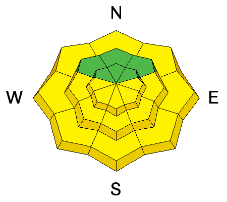
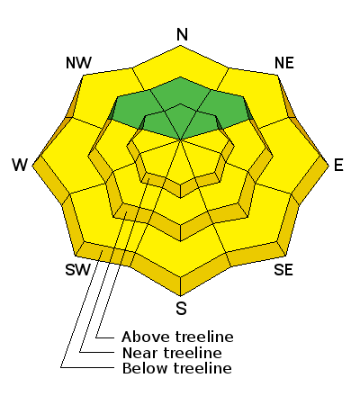
The avalanche danger is generally LOW in the morning and mostly stable snow conditions exist in all aspects. With daytime heating, the danger for wet slide activity will rise to MODERATE, and backcountry travelers need to be alert to signs of instability such as roller balls, pinwheels, or sloppy wet snow up around their boot tops. Follow the sun and get off of exposed aspects if any of these signs are present. Start early and end early, and as a general rule, plan to be out of avalanche terrain by around noon.
Low
Moderate
Considerable
High
Extreme
Learn how to read the forecast here
Special Announcements

The Abajo/Blue Mountain avalanche advisory will provide detailed information on the weekends. During the week, general information and a danger rating will be posted.

Weather and Snow

Spring time conditions are in effect. Supportable corn snow can be found in the mornings on SE-S-W aspects, though many of these areas are showing exposed ground. North facing aspects are either transitional, or wind affected dry snow.

I've seen very little wet avalanche activity through the warm spell of the past 10 days, and the snowpack is mostly stable. Nevertheless, it is good practice to be out of avalanche terrain by about noon under these conditions - earlier on slopes with an easterly component, and slightly later on those that face west - or if you feel the snow becoming sloppy, wet, or punchy.

Avalanche Problem #1
Wet Snow
Type
Location
Likelihood
Size
Description

With daytime heating, the danger for loose, wet slide activity will increase. Be alert to signs of instability such as roller balls, pinwheels, or sloppy wet snow up around their boot tops. Follow the sun and get off of exposed aspects if any of these signs are present. Start early and end early, and as a general rule, plan to be out of avalanche terrain by around noon.

Additional Information

Today will be the warmest yet with high temperatures at 10,000' to be around 50 degrees. Clouds will begin to stream into the area late Sunday as the pattern begins to change. Best chance for snow appears to be Wed-Thu.


General Announcements

If you are getting out into the mountains, we love to hear from you! You can SUBMIT OBSERVATIONS ONLINE

If you would like to have avalanche advisories emailed to you, SIGN UP HERE

Benefit the Utah Avalanche Center when you shop from Backcountry.com or REI: Click this link for Backcountry.com or this link to REI, shop, and they will donate a percent of your purchase price to the UAC. Both offer free shipping (with some conditions) so this costs you nothing!

Benefit the Utah Avalanche Center when you buy or sell on ebayIf you sign up for AmazonSmile and designate the Utah Avalanche Center as your favorite charity, they will donate a portion of everything you spend to the UAC. I doesn't cost you a penny and we'd really appreciate the help.​

The information in this advisory is from the US Forest Service which is solely responsible for its content. This advisory describes general avalanche conditions and local variations always occur.