Forecast for the Abajos Area Mountains

Eric Trenbeath
Issued by Eric Trenbeath for
Saturday, February 24, 2024
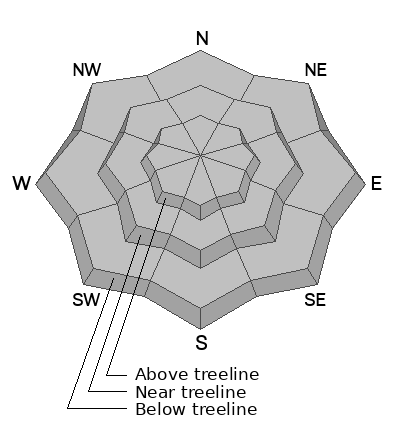
Although increasingly unlikely, human-triggered avalanches failing on a buried persistent weak layer remain possible on steep slopes that face W-N-E-SE. The danger is most prominent on slopes that face NW-N-E. You are most likely to trigger an avalanche in thin snowpack areas. You can reduce your risk by avoiding steep, rocky areas and slopes with complex terrain features.
Low
Moderate
Considerable
High
Extreme
Learn how to read the forecast here
Weather and Snow
It's been more than two weeks since the last snowfall and conditions are variable. Dry powder snow can still be found in sheltered, shady locations. Wind and sun crusts can be found on exposed slopes. The likelihood of triggering an avalanche on a deeply buried PWL continues to decrease, but it is still possible. We are now in a low likelihood, high consequence scenario. If you are stepping out into avalanche terrain, evaluate each slope on an individual basis. Aim to ride in areas with a deep snowpack. Avoid steep, rocky terrain, thinner areas along slope margins, and steep, blind rollovers or convexities. These are all likely trigger points. With an upcoming storm on the horizon, expect the danger to increase starting around Monday some time. Until then, enjoy a sunny weekend in the mountains!
NWS forecast for the Abajo Mountains.
Snow totals and temps at Buckboard Flat (8924')
Snow totals and temps at Camp Jackson (8858')
General Announcements
This forecast is from the U.S.D.A. Forest Service, which is solely responsible for its content. This forecast describes general avalanche conditions and local variations always occur.