[This blog entry is provided by pro UAC observer Tyler Falk. Tyler presented this work at the Utah Snow and Avalanche Workshop on November 4, and it is also scheduled for publication in the December issue of "Avalanche Review" which is published by the American Avalanche Association.]
Adjusting to a DifferentSnowpackClimate
The 2016/2017 winter season in the Salt Lake area mountains will be remembered by many to have felt overall warmer and wetter than normal. Some might even call it coastal, based on our weather and avalanche activity. I recently looked at all the available data on reported avalanches from the Salt Lake region on the Utah Avalanche Center website back to the 2009/2010 season through the present year. I ended up with eight seasons of consistent data. Before the 2009/2010 season there is incomplete data. I recorded all the persistent weak layer avalanches from each year. I included facets, depth hoar and crystal grain (surface hoar) in these numbers.
These three persistent weak layers are typically associated with most of the large unmanageable avalanches that lead to fatalities. Since the 2009/2010 season we have had eight fatalities in the SLC region, seven of those failed on a weak layer which was identified as facets. We typically see a fair amount of these avalanches, especially in the first half of the season. They are commonly found in our intermountain snowpack or even more prevalent in continental snowpacks like Colorado. In the 2016/2017 season we had very few facet-related avalanches, and our snowpack presented many traits of a Coastal region.
The Four Most Common ClimateRegions in the Western United States
Coastal: Typical regions are the Cascade Mountains in the Pacific coast states of Washington, Oregon, California. These areas typically have mild temperatures, lots of snow, high snow density and a low temperature gradient in the snowpack. Rain events are common at mountain locations. They typically have lots of direct action avalanches.(i.e. Wind & Storm Slabs) Cornices triggering loose snow avalanches and ice fall avalanches are more common in Coastal areas.
These regions can also have larger scale accidents involving more victims, for instance some of the accidents on Rainier over the years. The avalanche fatality records for Oregon and Washington on the CIAC site goes back to the 2008/2009 season. Much of the older data is incomplete but after reading through all the fatalities it showed very few persistent weak layer avalanches. Most of the avalanche fatalities I read about were wet, storm, or wind slabs. However, any region can display different traits from season to season. In 2014 Oregon displayed continental conditions. That season, some areas in Oregon had a layer of depth hoar form from early season snow and a period of high pressure which led to a fatality. Later in that year a surface hoar event got buried, causing another fatality.
Continental: This climate region includes most of Colorado, Wyoming, New Mexico and the Uinta Range. These areas see less snowfall than the Coastal regions, have colder temperatures, lower density snow and a higher temperature gradient due to the thinner snowpack. Typically this is where you see the persistent forms most often.
Intermountain: Regions typically include the Wasatch, most of Idaho, Montana, the Blue Mountains of Northeastern Oregon and some of Southwestern Colorado. These areas show climate characteristics of both Coastal and Continental regions.
Coastal Transition: Areas of Northern Idaho, Montana, and isolated locations in Oregon show traits of the coastal transitional zone. This climate zone is similar to the coastal regions but with less rain and snow.
Persistent Grain Types
By definition persistent grain types may persist for months or the entire season. “They have low fracture toughness; anisotropic: weak in shear, resistant to bonding under overburden slab.” They can be found in any region but typically are more frequent in Continental or Intermountain locations.
Facets- Facets, or squares as they are sometimes referred to, are associated with most the avalanche fatalities. They have sharp angles and form from large temperature gradients within the snowpack. Warm days with cold nights promote growth due to the temperature fluctuations. Typically smaller in size than depth hoar, usually around 1-2mm.
Crystal Grain (Surface Hoar)- Crystal grain is like the solid form of dew. It develops on the surface of the snowpack during clear calm nights. To grow “a sufficient supply of water vapor must be available in the air, and a high temperature gradient (inversion) must be present above a snow surface that is chilled below the ice point.(the dew-point temperature of sub-freezing air)” 2 Once it gets buried it can produce avalanches for a long period and pull out on very low slope angles. These grains can grow very large; one I found below in BCC near the bottom of God’s Lawnmower earlier this year was around 31mm.
Depth Hoar- These grains develop on the bottom of the snowpack. When the pack is shallow, the relatively warm ground and cold snow surface produce a high temperature gradient which promotes growth of depth hoar. They are cup shaped and typically not as prevalent as the first two persistent weak layers in accidents but do cause very deep unmanageable avalanches when they release. This grain type is large, typically at least 4mm.
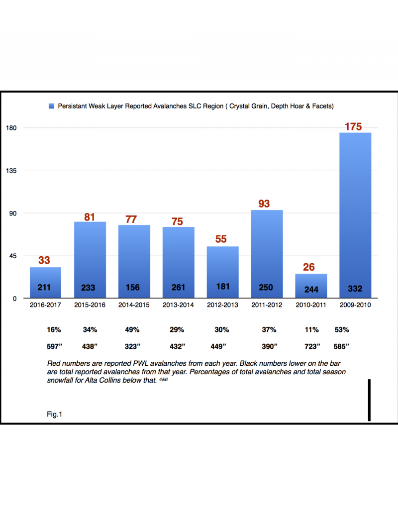
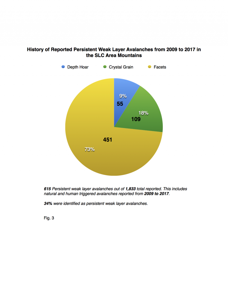
The data I found for the 2016/2017 season shows a normal amount of total avalanches but far fewer reported persistent weak layer avalanches. We had 249 reported avalanches with 33 of those avalanches failing on persistent weak layers, twenty-two of which were facets, four were depth hoar, and seven surface hoar avalanches. This is the fewest reported persistent weak layer avalanches since the season of 2010/2011. That year we only had 26 total reported persistent weak layer avalanches. In both of those seasons (2016/2017 & 2010/2011) we had no fatalities in the Salt Lake region. The opposite holds true as well. During the seasons with a high amount of PWL avalanches observed, we had the most fatalities.
Some of the seasons that stand out when looking at the data were:
2009-2010 (175 PWL avalanches) -2 SLC area fatalities: Grandview and Meadows
2011-2012 (93 PWL avalanches) - 3 SLC area fatalities: Snowbird, Kessler, Dutch Draw
2015-2016 (81 PWL avalanches) -2 SLC area fatalities: Pointy Peak and Gobblers
Each of these fatalities from the respective seasons were reported as facets being the weak layer the avalanche failed on.
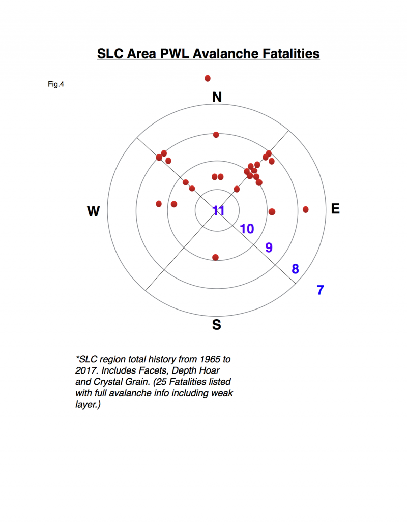
Looking back at the Salt Lake regions history of avalanche fatalities, there appeared to be 57 total dating back to 1965.There are complete records with weak layers identified for 33 of those 57. Out of those 33, 26 of them failed on persistent weak layers with most failing on facets. (79%) When looking at all of the PWL avalanches it appears to be a trend that most occurred above 9K feet on northwest through northeast aspects.A number of these areas have seen repeat fatalities through the years. These areas are: Canyons Periphery (6), Snowbird (5), Gobblers (4), Pioneer Peak (3), Kessler (2), Twin Lakes Pass (2).
Mar 6, 2017 | May 7, 2017 |
Brighton 169% | Brighton 117% |
Parleys 136% | Parleys -Bad Data |
Snowbird 170% | Snowbird 144% |
Thaynes Canyon 157% | Thaynes Canyon 127% |
The Alta Collins Snowtel plot (9662’) reached its highest height of snow depth on April 29, 2017 which was 161” (408cm) Alta Collins total snowfall for the year was 596.5”. Our average temperature at Alta this season for December through March was -3.6 C, which is 1.2 degrees warmer than normal. (Average is -4.8 C)8
These are all traits of a more Coastal snowpack. Looking back at the older data from the Karl Birkeland and Cary Mock paper on Snow Climatology from 2000 shows that if Alta does not have an Intermountain season, they are two times more likely to get a Costal or Maritime season over a Continental season.During their study they looked at data from 1946 to 1998 at the Alta UDOT station in upper Little Cottonwood. Out of those 52 years, they came to the conclusion that thirty of those seasons were classified as Intermountain with seventeen Coastal seasons and only five Continental seasons.
I went back to look at the data from the Alta UDOT guard station, then categorized all the seasons since 1998 which was when the Birkeland & Mock paper on Snow Climatology left off. I used the same flowchart Birkeland & Mock devised for classification of the seasons based on several weather variables- total rainfall, average temperature, December temperature gradient, SWE, and snowfall. Each variable had a specific amount which would trigger the next step on a flowchart. For example, SWE of more than 100cm would trigger a coastal classification. While working on this project, I reached out to Karl Birkeland, who mentioned that the classification system is not perfect and there are limitations. This became apparent when I obtained the classification result from our current 2016/2017 season for Alta Guard. The second variable in the flowchart is average temperature; warmer than -3.5 C for the average temperature during the winter’s four-month period triggers a Coastal classification. This year the Alta UDOT weather station averaged -3.6 C for those months, which is just one-tenth off the cutoff number. After following the flowchart further down, our classification ended up being Intermountain officially for the season at Alta. As mentioned earlier, climates can show traits of other regions at any time, for instance our Intermountain region showed obvious coastal traits all season.
Within the Salt Lake region we can see drastically different snowpacks and weather within very short distances; this illustrates the limitations of only looking at one station. We had different weather than normal in terms of the amount of rain at lower elevations, temperature, and distribution of the January crystal grain (surface hoar) layer around the region. I took a quick look at the Thaynes Canyon site in Park City for comparison. The Thaynes Snowtel site is at 9230’ and the Alta Guard location is around 8700’. I found that the average temperature for the four-month season was -2.5 C. This was within the Coastal classification for the Thanes Canyon location which shows drastically different temperatures within a relativity close proximity of each other.
After looking at the past 19 seasons at the Alta Guard site since the previous study was done, we have only had two Coastal seasons and three Continental seasons; the fourteen others were classified as Intermountain. Looking further back at the data: out of the seventy-one seasons classified since 1946 the total numbers are
Continental: 8 11.3%
Coastal:19 26%
Intermountain: 44 61.9%
Different avalanche climates in northern Utah means different types of avalanches and in places we might not normally see instabilities or red flags. For example, many of our storms this season have come in with a southern component where southern winds have been loading north and northeast aspects more frequently. Our typical northwest flow that favors upper Little Cottonwood usually gives us windslabs and cornices on southeast aspects. In addition, I have counted eight rain events at the mid elevations this year. At those mid and low elevation sites it seems like we have had more rain and thus more melt freeze crusts than normal. These can lead to avalanches on hardness changes or on a variety of crusts. The melt freeze crusts could also set us up for more wet slab avalanche formation. When the free water moves through the pack and hits a crust it can cause a wet slab avalanche. Although not in the Salt Lake region, Logan Canyon experienced a natural cycle which hit the road due to huge amounts of wet heavy snow in January. This cycle seamed abnormal for the area, likely due to the coastal weather conditions.
Although it’s extremely hard to predict and forecast seasonal avalanche conditions and climates ahead of time, hopefully by recognizing current trends and avoiding suspect terrain early in the season it can make staying on top a little easier. Until weather forecasting can better predict long term temperature, snow and weather data we will be limited to shorter term forecasts.


