

Observer Name
Wilson, Fletcher, Hardesty
Observation Date
Friday, March 27, 2020
Avalanche Date
Friday, March 27, 2020
Region
Ogden » Snowbasin
Location Name or Route
Snowbasin, No Name
Elevation
8,600'
Aspect
Northeast
Slope Angle
38°
Trigger
Skier
Trigger: additional info
Unintentionally Triggered
Avalanche Type
Soft Slab
Avalanche Problem
Persistent Weak Layer
Weak Layer
New Snow/Old Snow Interface
Depth
20"
Width
300'
Caught
2
Carried
1
Buried - Partly
2
Snow Profile Comments
Snow profile at crown of avalanche showed a 45cm soft slab overlying a thin temperature crust.
Between 3/21 and 3/23 the snow surface from the previous storm warmed enough to form a friable 1cm crust on northeast aspects, but there was no crust where the slope rolled more northerly. In the same period, small surface hoar and facets were formed, and this interface was the weak layer in the No Name avalanche.
Above the weak layer, 10cm of graupel and rimed particles and another 35cm of lighter snow made up the slab that failed 300 feet wide and 18" deep. The storm total was 2.5 inches of SWE at Snowbasin.
We dug 5 quick test pits, 3 at and adjacent to the crown. In each of these a mid-storm instability on stellars was noted (moderate, resistant planar compression test results, with no propagation in extended column tests). In several test pits we also initiated failure on top of the graupel, although this required harder hits and also failed to propagate. None of the tests showed propagation on the weak layer responsible for the D2.5 avalanche.

Comments
A party of 5 left the Snowbasin parking lot around 6:45 a.m., with a loose plan to ski the southeast shot from No Name peak. They carried transceivers, shovels, probes, airbags, and two-way radios. The individual who reported the slide was a 20-year season pass holder at Snowbasin, and had skied No Name perhaps 40 times; "I have the 'No Name' ski-run sign hanging in my office" he noted wryly. He has skied for 2 years in the backcountry. All members had taken a level I avalanche class.
By the time the party reached the summit of No Name, the avalanche advisory for the Ogden area mountains had been issued. Together they reviewed it at the top of the run: Moderate above 8,500 feet, low for northerly aspects below 8,500'. They considered the run back and to the southeast to be safer (at least in the early morning), primarily because it was lower angle. They recognized that No Name could produce an avalanche after the recent 2-foot storm, but with no signs of wind loading and with a Moderate hazard forecast they felt it seemed reasonable. This assessment was reinforced as they watched another party of 3 ski the line without triggering sluffs or slabs. The party heard of a catch-and-carry incident in Ogden Chute as they transitioned, but did not re-evaluate their decision.
At this point the party divided so that the three with work commitments could take one long home run down No Name while the other two could do a lap to the southeast before hiking back up to exit via No Name. The triggering party descended to an "apex" from which they skied one at a time. The first person skied to a tree where he felt relatively safe and stopped to film the others. The second person, a snowboarder, rode right to the first person before the slide was triggered and propagated hundreds of feet back towards the 3rd person. In the video shared by the triggering party, you'll see the friend arrive and then confusion as the whole slope starts to move.
Both riders were incredibly lucky. The skier skied 20' to tuck behind a tree, where he was buried up to his chest and pulled his airbag. He lost both poles but was uninjured. The snowboarder went for a 300 foot ride which included periods fully under the snow. Towards the end his head came up just in time to see a dead tree immediately below him. He straddled it with the board and came to a stop. He was bruised and had twisted a knee but was otherwise fine. The 3rd skier could not see his partners below, but both responded when he called them on the two-way radio.
As the third skier descended, the first radioed a warning to be careful of hangfire. This was a very reasonable concern.
When the three of us (including Snowbasin patrol director GR Fletcher and UAC forecaster Drew Hardesty) went to investigate the avalanche this afternoon, one person remained 150 feet above the crown to prevent other skiers from triggering hangfire on partners below.
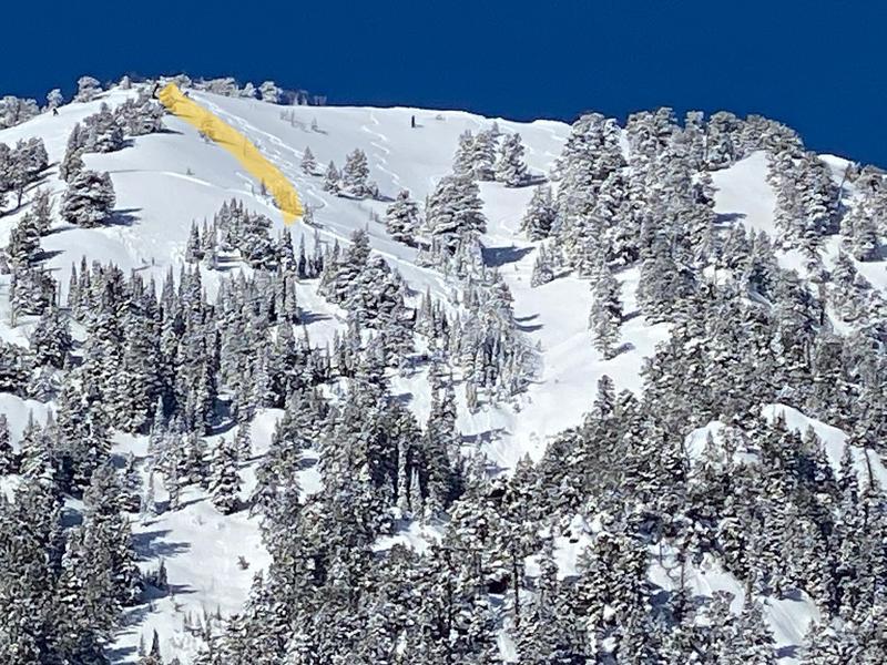
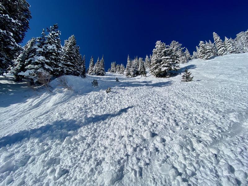
Photos:
- Tracks into the crown
- Crown line from the bed-surface
- Debris


Comments
The skier who reported the avalanche had several insights he wanted to share:
1) Choose a truly safe spot when you're skiing one-at-a-time in avalanche terrain. He said he should have skied further and communicated by radio if necessary.
2) Use all your information, even if you get it late in the game. He said the Mount Ogden slide should have prompted discussion within their group.
3) Watch-out for rushed decision making; the time crunch influenced their choices.
4) Make a plan before heading into the mountains.
5) Step out slowly when uncertainty is high; they has skied on Ben Lomond the previous weekend, but this was their first run since the storm.
Comments
We commend and thank the reporting party for contacting the avalanche center immediately after triggering this large avalanche, and for sharing their photos and stories for the benefit of other skiers.
The three of us investigating the slide all felt it was exceptionally tricky and challenging situation; test pits did not reveal the layer of concern, and surface hoar at the interface was not an avalanche problem we had been tracking.
Finally, we want to remind skiers and riders that within ski area boundaries we now have a backcountry snowpack. The runs may feel familiar, but there is no ski patrol to mitigate avalanche hazard.
Video
Video
Coordinates