Forecast for the Skyline Area Mountains

Brett Kobernik
Issued by Brett Kobernik for
Wednesday, December 7, 2016

Most of the terrain has a LOW avalanche danger. Lingering drifts from the recent wind may still be sensitive and could be triggered by a person. A MODERATE avalanche danger exists along the higher ridges and peaks.
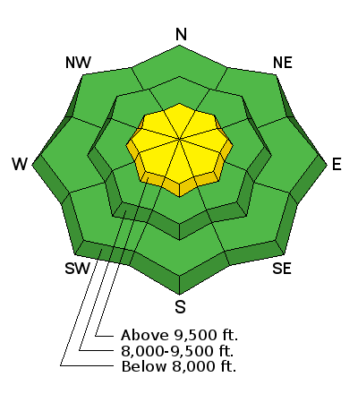
Low
Moderate
Considerable
High
Extreme
Learn how to read the forecast here
Special Announcements

Please join us at Big Pine Sports for an avalanche presentation on Dec 16th at 6:30pm. I will be talking about the current conditions and sharing tips on how to stay out of avalanches. I'll cover anything else the audience is interested in.

Weather and Snow

Well, it appears we lucked out with the small storm that rolled through last night. It deposited 4 to 5 inches of new snow. Ridgetop temperatures are right around 0 F and the westerly wind has slowed since yesterday with light to moderate ridgetop speeds currently.

Ad
Additional Information

General Announcements

We will publish full detailed advisories Saturday and Sunday mornings by 7am. We will also be publishing basic avalanche danger ratings & info during the week.

If you are getting out into the mountains, we love to hear from you! You can SUBMIT OBSERVATIONS ONLINE or EMAIL US

If you would like to have avalanche advisories emailed to you, SIGN UP HERE

We can provide basic avalanche awareness presentations for your school, group or club. To enquire, CLICK HERE