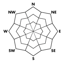


| Advisory: Uintas Area Mountains | Issued by Craig Gordon for November 24, 2012 - 5:51am |
|---|


Above treeline
Near treeline
Below treeline
|
bottom line Terrain to avoid- steep, upper elevation, north facing slopes above treeline where fresh wind drifts may still be sensitive to the weight of a rider and there's an isolated possibility of human triggered avalanches breaking to the ground. LOW avalanche danger exists on wind sheltered slopes, South facing terrain, and slopes that were bare prior to the early November storm.
|
 |
special announcement Mirror Lake Highway is a mess and plowing is done for the season. Wolf Creek Pass remains open, but don't let the easy access to nearby terrain lull you into a false sense of security. Be prepared for your own self rescue. Wear and know how to use a beacon, shovel, and probe. |
 |
current conditions High pressure is the dominant feature to our weather pattern, giving us clear skies, light westerly winds, and temperatures in the low to mid 30's this morning. Wednesdays nukin' southwesterly winds wreaked havoc on the eastern front. Much of the upper elevation wind exposed terrain now resembles a moonscape comprised of breakable crust, windboard, and rocks. But wait.... there's more. Among all the variable conditions there may be a patch or two of soft settled snow on wind sheltered slopes facing the north half of the compass. Recent snow and avalanche observations can be found here. Wondering why last winter was so crazy? Click here to watch the 2011-12 Utah Winter Review... an excellent recap of last years conditions. |
 |
recent activity No recent avalanche activity to report. |
| type | aspect/elevation | characteristics |
|---|
 |


Above treeline
Near treeline
Below treeline
|
|
|
description
Yesterday, I found the recent wind deposited snow to be stiff and unreactive. However, given the size of the Uinta range, I bet if you went hunting for a wind slab sensitive to your additional weight, you could find it. Trouble is, given the thin snow cover and all the obstacles barely hidden under the snow, triggering even a small slide could have body beating consequences. Best to play it safe and avoid steep, wind loaded slopes facing the north half of the compass. |
| type | aspect/elevation | characteristics |
|---|
 |


Above treeline
Near treeline
Below treeline
|
|
|
description
Given the overall depth of our snow, we've seen a lot worse snowpack structure in past years. While we haven't seen or heard of any slides breaking to old October snow I'm not ready to completely discount the possibility. Yes, you'd really have to go out of your way to find terrain where you could trigger a slide that breaks to the ground, but given the miserable consequences of going for a ride in an avalanche it's worth mentioning. I'd continue to be suspicious of steep, rocky, upper elevation north facing terrain where triggering a slide could result in a season ending injury. |
 |
weather It'll be a beautiful day in the mountains with sunny skies, light winds, and high temperatures climbing into the low 40's. Overnight lows dip into the upper 20's. A dry cold front slides to the east of our region Sunday, ramping winds up a bit and possibly producing a flurry or two. High pressure quickly rebuilds for most of the upcoming. There's is a glimmer of hope for a pattern change towards the end of the week which would be welcome news... more details in the coming days. |
| general annoucements Remember your information can save lives. If you see anything we should know about, please participate in the creation of our own community avalanche advisory by submitting snow and avalanche conditions. You can call me directly at 801-231-2170, email [email protected], or email by clicking HERE This is a great time of year to schedule a free avalanche awareness presentation for your group or club. You can contact me at 801-231-2170 or email [email protected] Donate to your favorite non-profit –The Friends of the Utah Avalanche Center. The UAC depends on contributions from users like you to support our work. The information in this advisory expires 24 hours after the date and time posted, but will be updated by 7:00 AM Sunday November 25th. |