Avalanche Advisory
| Advisory: Salt Lake Area Mountains | Issued by Evelyn Lees for April 28, 2013 - 4:56am |
|---|


Above 9,500 ft.
8,000-9,500 ft.
Below 8,000 ft.
|
bottom line A warmer night, a warmer day, an EARLIER START and EARLIER FINISH today. The avalanche danger is LOW early this morning while the surface snow is still frozen, but the danger will more rapidly increase to MODERATE as the day and the snow heats up. Get off of and out from under steep slopes as the snow becomes damp, starts to sluff or the crusts become punchy or collapse. Western Uintas: The avalanche danger will increase to CONSIDERABLE with daytime heating, due to the potential for deep slab avalanches releasing near the ground.
|


 |
special announcement Wet avalanche conditions this weekend will be unpredictable, especially in the Uinta Mountains where a more unstable snowpack usually exists. We urge everyone to choose conservative terrain this weekend. Stay off of--and out from underneath--steep slopes in the heat of the afternoon. We will issue intermittent advisories as conditions warrant for the Salt Lake region only. They will end for the season after this weekend. I will still post observations from you each evening and early morning as well, so if you're getting out, please let everyone in our community know what you find. The rest of our staff is off for the season and most of the ski resorts are closed for the season, so your feedback and observations are important. |
 |
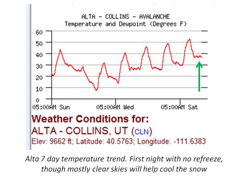
current conditions An approaching weak disturbance has brought occasional bands of high thin clouds across northern Utah overnight, and warmer temperatures. Most mountain stations are 6 to 7 degrees warmer this morning than yesterday - in the upper 30s to mid 40s in the Salt Lake mountains, 40s on the Park City side and in the Provo mountains, and in the 40s and 50s in the Ogden mountains. Winds are from the west to southwest, in the 10 to 15 mph range, with the high peaks averaging 15 to 25 mph. Excellent spring turning and riding was reported yesterday, on very supportable snow in the morning, with cold snow on steeper upper elevation northerly facing slopes. Good corn conditions were found until around noon on the southeast through west facing slopes. This morning's refreeze will be shallower and shorter lived. |
 |
recent activity No avalanche activity was reported yesterday. |
Avalanche Problem 1over the next 24 hours
| type | aspect/elevation | characteristics |
|---|
 |
Above 9,500 ft.
8,000-9,500 ft.
Below 8,000 ft.
|
|
|
description
The combination of warmer temperatures and some overnight clouds will shorten the length of time the snow will be firm today. While temperatures have been increasing gradually for the past 5 days, helping ease the snow pack into a spring regime, the lack of an overnight refreeze is always a red flag.
If you’re heading into the backcountry today, start and finish early. Both wet sluffs and possibly wet slab avalanches are possible, with all aspects and elevations becoming suspect as the day heats up. Be observant of warning signs of too much heating:
Any of these signs mean it's time to head home, or at least change to an aspect with cooler snow.. Remember, even "smaller" slides can be dangerous and inescapable in steep terrain - they can take you off a cliff or for a long ride. Plan your trip to have a safe exit back to the car. Heating will continue though tonight and Monday, keeping the danger of wet avalanches elevated through Monday. A cold front Monday night should finally cool the snow for several days. Note on the danger rose: almost no snow exists on southerly facing slopes below 8,000'. Also, remember, most of the ski resorts are closed for the season with no avalanche control, so treat it just like backcountry terrain. |

 |
weather A weak disturbance approaching the area will bring partly cloudy skies and warmer temperatures today, with 8000' highs approaching 60, and 10,000 highs warming into the mid 40s. Winds will be from the southwest, in the 10 to 15 mph range, with the high peaks averaging to 25 mph, gusting into the 30s. The overly warm temperatures will continue tonight through Monday, followed by a sharp cool down as a windy dry cold front crosses the area Monday night. This will be followed by a cooler northwesterly flow for several days. |
| general annoucements If you trigger an avalanche in the backcountry - especially if you are adjacent to a ski area – please call the following teams to alert them to the slide and whether anyone is missing or not. Rescue teams can be exposed to significant hazard when responding to avalanches, and do not want to do so when unneeded. Thanks. Salt Lake and Park City – Alta Central (801-742-2033), Canyons Resort Dispatch (435-615-3322) Twitter Updates for your mobile phone - DETAILS Subscribe to the daily avalanche advisory e-mail click HERE. UDOT canyon closures UDOT at (801) 975-4838 Remember your information can save lives. If you see anything we should know about, please participate in the creation of our own community avalanche advisory by submitting snow and avalanche conditions. You can also call us at 801-524-5304 or 800-662-4140, email by clicking HERE, or include #utavy in your tweet. Donate to your favorite non-profit –The Friends of the Utah Avalanche Center. The UAC depends on contributions from users like you to support our work. For a print version of this advisory click HERE.
This advisory is produced by the U.S. Forest Service, which is solely responsible for its content. It describes only general avalanche conditions and local variations always exist. Specific terrain and route finding decisions should always be based on skills learned in a field-based avalanche class. |