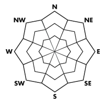


| Advisory: Ogden Area Mountains | Issued by Brett Kobernik for April 3, 2013 - 7:08am |
|---|


Above 8,500 ft.
7,000-8,500 ft.
Below 7,000 ft.
|
bottom line The avalanche danger will reach MODERATE today with daytime heating. Natural wet loose snow avalanches are possible. Avoid travel in confined terrain such as gullies and couliors and consider your escape/exit route if the snow becomes unstable.
|
 |
special announcement Drew Hardesty has been working with UDOT and other agencies on proposed avalanche information signage at the base of the Cottonwood Canyons and perhaps other highways heading to popular trailheads. We are looking for a little more public feedback on our two 'yes/no question' survey. CLICK HERE FOR THE SURVEY Gabe Garcia is doing a study on an unusual day that occurred in upper Little Cottonwood on Nov 13, 2012 involving numerous human triggered avalanches with injuries and a fatality. SURVEY |
 |
current conditions Skies have cleared out and temperatures are hovering around freezing give or take a little. The annoying east northeast winds that picked up yesterday morning did their damage and have slowed and are switching more northwest. The sun did come out for periods yesterday afternoon and along with warm 'spring like' temperatures, you'll most likely find a crust on the surface on many aspects at the low and mid elevations and sunny aspects up high. |
 |
recent activity No avalanche activity was reported from the Ogden or Provo area mountains as these regions did not pick up much snow from the last storm.
|
| type | aspect/elevation | characteristics |
|---|
 |


Above 8,500 ft.
7,000-8,500 ft.
Below 7,000 ft.
|
|
|
description
Daytime heating of the new snow will most likely produce some 'rollerballing' and perhaps some wet loose snow avalanches. As the newest snow becomes damp, it's time to start paying attention to where you are. 'Rollerballing' often precedes wet activity. |
| type | aspect/elevation | characteristics |
|---|
 |


Above 8,500 ft.
7,000-8,500 ft.
Below 7,000 ft.
|
|
|
description
|
 |
weather A ridge of high pressure will affect our area over the next two days with clear skies and warming temperatures. Today's highs will get up around 50 at 8000 feet and 40 along the ridges. Northwest winds will continue to shift more west and will be in the light to moderate speed category. An active pattern starts on Friday with a weakening wave that may produce a little snow and then some more waves for later in the weekend and into next week. |
| general annoucements Go to http://www.backcountry.com/utah-avalanche-center to get EVEN MORE DISCOUNTED tickets from our partners at Beaver Mountain and Sundance. All proceeds benefit the Utah Avalanche Center. If you trigger an avalanche in the backcountry - especially if you are adjacent to a ski area – please call the following teams to alert them to the slide and whether anyone is missing or not. Rescue teams can be exposed to significant hazard when responding to avalanches, and do not want to do so when unneeded. Thanks. Salt Lake and Park City – Alta Central (801-742-2033), Canyons Resort Dispatch (435-615-3322) Ogden – Snowbasin Patrol Dispatch (801-620-1017) Powder Mountain Ski Patrol Dispatch (801-745-3772 ex 123) Provo – Sundance Patrol Dispatch (801-223-4150) Dawn Patrol Forecast Hotline, updated by 05:30: 888-999-4019 option 8. Twitter Updates for your mobile phone - DETAILS Daily observations are frequently posted by 10 pm each evening. Subscribe to the daily avalanche advisory e-mail click HERE. UDOT canyon closures UDOT at (801) 975-4838 Wasatch Powderbird Guides does daily updates about where they'll be operating on this blog http://powderbird.blogspot.com/ . Remember your information can save lives. If you see anything we should know about, please participate in the creation of our own community avalanche advisory by submitting snow and avalanche conditions. You can also call us at 801-524-5304 or 800-662-4140, email by clicking HERE, or include #utavy in your tweet. Donate to your favorite non-profit –The Friends of the Utah Avalanche Center. The UAC depends on contributions from users like you to support our work. For a print version of this advisory click HERE. This advisory is produced by the U.S. Forest Service, which is solely responsible for its content. It describes only general avalanche conditions and local variations always exist. Specific terrain and route finding decisions should always be based on skills learned in a field-based avalanche class. |