

| Advisory: Ogden Area Mountains | Issued by Evelyn Lees for January 28, 2013 - 7:02am |
|---|


Above 8,500 ft.
7,000-8,500 ft.
Below 7,000 ft.
|
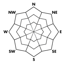
bottom line Dangerous avalanche conditions exist - the avalanche danger is CONSIDERABLE today for triggering a slide 1 to 2 feet deep on steep slopes facing west through north through east at the mid and upper elevations. Any steep, wind drifted slope also has a CONSIDERABLE danger. Human-triggered slides likely, and can be triggered from a distance. The avalanche danger is MODERATE on all other steep slopes for triggering a new snow slide.
|
 |
special announcement Strong winds and additional snow are forecast for tonight through Wednesday, and the avalanche danger will continue to rise. |
 |
current conditions Skies are trying to clear this morning, but some areas of clouds remain, with light snow still falling in a few locations favored by northwest flow. Temperatures crashed behind the front, into the low teens, with single digits along the higher ridge lines. Winds are currently from the west to northwest and light, less than 15 mph, with gusts less than 25. Storm totals are generally in the 10 to 15” range from Ogden to Provo. The initial dense windblown graupel did an excellent job of smoothing out the old snow surface and filling in tracks, and is topped off by increasingly low density snow - we’re talking a classic Utah powder day, with excellent snowmobiling, touring and snowshoeing conditions. |
 |
recent activity Sensitive wind drifts formed early along the ridges, and intentional slope cuts were easily triggering soft slabs up to 2 feet deep yesterday, including in graupel pools beneath cliff bands. Backcountry slides reported include intentionally triggered slides off the Snake Creek and the Desolation ridge line.
|
| type | aspect/elevation | characteristics |
|---|
 |


Above 8,500 ft.
7,000-8,500 ft.
Below 7,000 ft.
|
|
|
description
Two storms in the past five days have added a significant load of snow, especially on any wind drifted slope. This new snow has overloaded the weak, sugary January facets on some slopes at the mid and upper elevations. Slides could be triggered along the wind loaded ridgelines, but also mid slope break overs and protected mid elevation slopes. Shallow snow pack areas continue to have the weakest snow. It’s quite a tricky pattern in general, with more variation than usual for January – one slope may be stable, the next will slide. Cracking and collapsing indicate the weak layering is present where you are, and could fail on a steep slope. Slides could be triggered from a distance, from the side or below. The strange layering on some lower elevation slopes, of facets capped with a rain crust, and then new snow also means steep slopes and terrain traps such as gullies should be avoided at the low elevations, too. |
| type | aspect/elevation | characteristics |
|---|
 |


Above 8,500 ft.
7,000-8,500 ft.
Below 7,000 ft.
|
|
|
description
The new snow will be sensitive to people on steep slopes, especially where wind drifted. The initial dense snow came with very strong winds, and drifts will be most widespread on slopes facing northwest through east. Drifts can also be found off the ridgelines, along gully walls, slope break overs and sub ridges. Watch for pooling of the graupel at the bottom of cliffs. There was poor bonding of the new snow to some of the crusts beneath. |
 |
weather Light snow showers will continue to taper off throughout the day, and shouldn’t add more than an inch or two of additional snow. Temperatures will remain in the single digits to mid-teens at most elevations. The northwesterly winds will start to increase by this afternoon, into the 10 to 20 mph range. Gusts along the high ridges will increase into the 30s. The next wave of snow will move into the area tonight, accompanied by strong northwesterly winds, with an additional 8 to 12” of snow possible by Tuesday afternoon. A third storm is forecast for Wednesday into Thursday. |
| general annoucements Go to http://www.backcountry.com/utah-avalanche-center to get tickets from our partners at Park City, Beaver Mountain, Canyons, Sundance, and Wolf Mountain. All proceeds benefit the Utah Avalanche Center. If you trigger an avalanche in the backcountry - especially if you are adjacent to a ski area – please call the following teams to alert them to the slide and whether anyone is missing or not. Rescue teams can be exposed to significant hazard when responding to avalanches, and do not want to do so when unneeded. Thanks. Salt Lake and Park City – Alta Central (801-742-2033), Canyons Resort Dispatch (435-615-3322) Ogden – Snowbasin Patrol Dispatch (801-620-1017) Powder Mountain Ski Patrol Dispatch (801-745-3773 ex 123) Provo – Sundance Patrol Dispatch (801-223-4150) Dawn Patrol Forecast Hotline, updated by 05:30: 888-999-4019 option 8. Twitter Updates for your mobile phone - DETAILS Daily observations are frequently posted by 10 pm each evening. Subscribe to the daily avalanche advisory e-mail click HERE. UDOT canyon closures UDOT at (801) 975-4838 Wasatch Powderbird Guides does daily updates about where they'll be operating on this blog http://powderbird.blogspot.com/ . Remember your information can save lives. If you see anything we should know about, please participate in the creation of our own community avalanche advisory by submitting snow and avalanche conditions. You can also call us at 801-524-5304 or 800-662-4140, or email by clicking HERE Donate to your favorite non-profit –The Friends of the Utah Avalanche Center. The UAC depends on contributions from users like you to support our work. For a print version of this advisory click HERE. This advisory is produced by the U.S. Forest Service, which is solely responsible for its content. It describes only general avalanche conditions and local variations always exist. Specific terrain and route finding decisions should always be based on skills learned in a field-based avalanche class |