

Avalanche Advisory
| Advisory: Ogden Area Mountains | Issued by Bruce Tremper for January 25, 2013 - 7:15am |
|---|


Above 8,500 ft.
7,000-8,500 ft.
Below 7,000 ft.
|
bottom line Avoid: Stay off of, and out from underneath, all slopes below about 7,000' steeper than about 34 degrees because of wet avalanche conditions. This includes the foothills and low elevation ice climbs. Safer terrain: You can always find safer terrain on slopes of 30 degrees or less that are not locally connected to steeper terrain.
|
 |
special avalanche bulletin Watch for low elevation, wet avalanche activity today from the valley floor up to about 7,000'. Stay off of, and out from underneath, steep slopes. This includes the foothills and low elevation ice climbs. |

 |
current conditions It was a dark and gloomy day yesterday with steady drizzle from the valley floor to 7,000' and light snow and fog above. Rain rapidly warmed the inversion layer in the valleys with freezing rain, which closed the airport, caused many traffic accidents and you needed crampons to walk on most sidewalks. The snow remains saturated below 6,000' with damp snow on the surface at 7,000' and 3-6 inches of new snow above 8,000'. Ridgetop winds remain moderate from the west. The rain-snow line remains around 7,000'. (See my short video on a synopsis of snowpack conditions.) |
 |
recent activity Widespread wet, loose avalanches occurred yesterday at low elevations as the cold, dry snow rapidly warmed due to rain. Provo canyon had the most spectacular results, (see Observation and photos in Detailed Info). Wet, loose avalanches and peeling ice occurred above the ice climbs in Provo Canyon and Little Cottonwood Canyon. At upper elevations, the strong southwest ridge top winds drifted snow onto the north through east facing slopes and there was several fresh wind slabs reported. |
Avalanche Problem 1over the next 24 hours
| type | aspect/elevation | characteristics |
|---|
 |
Above 8,500 ft.
7,000-8,500 ft.
Below 7,000 ft.
|
|
|
description
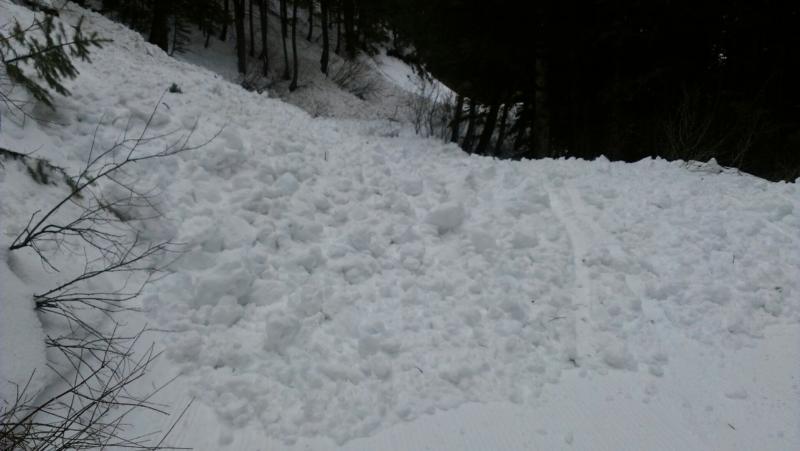
Rain on cold, dry snow almost always causes instant avalanches. Although most of the rain has died down, watch for continued wet, loose avalanches today on low elevation, steep slopes. This includes low elevation ice climbs and steep slopes in the foothills. I'm calling it a Considerable avalanche danger on steep slopes with wet, soggy snow, which you will find mostly below 7,000'. Especially stay out of terrain traps such as gullies where small avalanches can pile up very deeply. Here is an image from the low elevations of the Provo area mountains.
|

Avalanche Problem 2over the next 24 hours
| type | aspect/elevation | characteristics |
|---|
 |
Above 8,500 ft.
7,000-8,500 ft.
Below 7,000 ft.
|
|
|
description
Moderate winds from the southwest and west yesterday and overnight drifted snow onto downwind terrain especially along the upper elevation ridges. As usual, avoid all steep slopes with recent wind drifts. These will look smooth and rounded and can range from being hard to soft. |

Avalanche Problem 3over the next 24 hours
| type | aspect/elevation | characteristics |
|---|
 |
Above 8,500 ft.
7,000-8,500 ft.
Below 7,000 ft.
|
|
|
description
Use normal caution on mid elevation terrain between 8,000 and 9,500'. Weak, faceted snow and surface hoar exists under a thin layer of new snow on shady aspects (north half of the compass). Although the new snow probably does not weigh enough to overload these weak layers right now, you may find some areas where you can trigger a slab. Be sure to use test slopes and regularly dig down with your hand to test the bonding between the new and old snow. |
 |
weather We should have another warm, gloomy day with low elevation moisture and continued smog in the valleys. Light rain may fall at times below 7,000' with light snow above. Temperatures will be above freezing except for elevations above about 10,000'. We may see some riming conditions at upper elevations this morning. Ridge top winds will continue to blow 20-25 mph from the west and southwest. Saturday will see similar conditions. A cold front on Sunday into Monday will finally scoop out our smog in the valleys and we will get an added bonus of 8-12 inches of new snow in the mountains. Yippee!!!! It looks like we will continue to have weaker pulses of moisture for a few days afterwards. |
| general annoucements Go to http://www.backcountry.com/utah-avalanche-center to get tickets from our partners at Park City, Beaver Mountain, Canyons, Sundance, and Wolf Mountain. All proceeds benefit the Utah Avalanche Center. If you trigger an avalanche in the backcountry - especially if you are adjacent to a ski area – please call the following teams to alert them to the slide and whether anyone is missing or not. Rescue teams can be exposed to significant hazard when responding to avalanches, and do not want to do so when unneeded. Thanks. Salt Lake and Park City – Alta Central (801-742-2033), Canyons Resort Dispatch (435-615-3322) Ogden – Snowbasin Patrol Dispatch (801-620-1017) Powder Mountain Ski Patrol Dispatch (801-745-3773 ex 123) Provo – Sundance Patrol Dispatch (801-223-4150) Dawn Patrol Forecast Hotline, updated by 05:30: 888-999-4019 option 8. Twitter Updates for your mobile phone - DETAILS Daily observations are frequently posted by 10 pm each evening. Subscribe to the daily avalanche advisory e-mail click HERE. UDOT canyon closures UDOT at (801) 975-4838 Wasatch Powderbird Guides does daily updates about where they'll be operating on this blog http://powderbird.blogspot.com/ . Remember your information can save lives. If you see anything we should know about, please participate in the creation of our own community avalanche advisory by submitting snow and avalanche conditions. You can also call us at 801-524-5304 or 800-662-4140, or email by clicking HERE Donate to your favorite non-profit –The Friends of the Utah Avalanche Center. The UAC depends on contributions from users like you to support our work. For a print version of this advisory click HERE. This advisory is produced by the U.S. Forest Service, which is solely responsible for its content. It describes only general avalanche conditions and local variations always exist. Specific terrain and route finding decisions should always be based on skills learned in a field-based avalanche class |