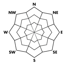


| Advisory: Ogden Area Mountains | Issued by Evelyn Lees for November 22, 2012 - 6:57am |
|---|


Above 8,500 ft.
7,000-8,500 ft.
Below 7,000 ft.
|
bottom line The avalanche danger in the Ogden area mountains is LOW. However, if you are traveling at the higher elevations, look for and avoid any slope steeper than about 35 degrees with recent deposits of wind drifted snow. These snow drifts will be along ridge lines and in open terrain, most widespread on northerly and easterly facing slopes at the upper elevations. The rest of the terrain has a LOW avalanche danger – carry avalanche gear (beacons, shovels, probes) and travel on steep slopes one at a time.
|
 |
current conditions The cold front skipped through town, leaving behind a few snowflakes and cooler temperatures. This morning, under clearing skies, temperatures in the Ogden area mountains are in the upper 20s to low 30s. The winds shifted to the northwest last night, and are currently less than 10 miles per hour at all but a few locations. The early season snow pack in the Ogden area mountains is very shallow, generally less than a foot, and options for backcountry travel are limited. |
 |
recent activity No new avalanches were reported, but there were no backcountry observations from the wind zone up high. |
| type | aspect/elevation | characteristics |
|---|
 |


Above 8,500 ft.
7,000-8,500 ft.
Below 7,000 ft.
|
|
|
description
If you do travel along the highest ridges of the Ogden area mountains, you may find a few stubborn wind drifts along the high ridges and down into open bowls can be triggered today on steep slopes. Wind speeds were strongest from the southwest, and moderate from the west, so the drifts will be most common on northerly and easterly facing slopes. |
| type | aspect/elevation | characteristics |
|---|
 |


Above 8,500 ft.
7,000-8,500 ft.
Below 7,000 ft.
|
|
|
description
Where there is snow, most of the Ogden backcountry terrain has a Low Avalanche Danger, which doesn’t mean no danger - avalanches are possible in isolated or extreme terrain. |
 |
weather A series of beautiful, almost spring like days are in store for the mountains, with gradually warming temperatures and light winds today through Saturday. 8,000’ highs today will be near 30, 10,000’ highs in the 20s. The northwesterly winds will remain light, averaging less than 15 mph on all but a few of the highest peaks. Skies will be mostly clear through Saturday, with 10,000’ temperature warming into the mid 30s, and winds gradually shifting back to the west and southwest. A small storm is forecast to clip northern Utah on Sunday, perhaps delivering a few inches of snow. |
| general annoucements If you trigger an avalanche in the backcountry - especially if you are adjacent to a ski area – please call the following teams to alert them to the slide and whether anyone is missing or not. Rescue teams can be exposed to significant hazard when responding to avalanches, and do not want to do so when unneeded. Thanks. Salt Lake and Park City – Alta Central (801-742-2033) Ogden – Snowbasin Patrol Dispatch (801-620-1017) Provo – Sundance Patrol Dispatch (801-223-4150) Dawn Patrol Forecast Hotline, updated by 05:30: 888-999-4019 option 8. Twitter Updates for your mobile phone Daily observations are frequently posted by 10 pm each evening. Subscribe to the daily avalanche advisory e-mail click HERE. UDOT canyon closures UDOT at (801) 975-4838 Wasatch Powderbird Guides does daily updates about where they'll be operating on this blog http://powderbird.blogspot.com/ . Remember your information can save lives. If you see anything we should know about, please participate in the creation of our own community avalanche advisory by submitting snow and avalanche conditions. You can also call us at 801-524-5304 or 800-662-4140, or email by clicking HERE Donate to your favorite non-profit –The Friends of the Utah Avalanche Center. The UAC depends on contributions from users like you to support our work. Evelyn will update this forecast tomorrow. Thanks for calling. If you trigger an avalanche in the backcountry - especially if you are adjacent to a ski area – please call the following teams to alert them to the slide and whether anyone is missing or not. Rescue teams can be exposed to significant hazard when responding to avalanches, and do not want to do so when unneeded. Thanks. Salt Lake and Park City – Alta Central (801-742-2033) Ogden – Snowbasin Patrol Dispatch (801-620-1017) Provo – Sundance Patrol Dispatch (801-223-4150) Dawn Patrol Forecast Hotline, updated by 05:30: 888-999-4019 option 8. Twitter Updates for your mobile phone Daily observations are frequently posted by 10 pm each evening. Subscribe to the daily avalanche advisory e-mail click HERE. UDOT canyon closures UDOT at (801) 975-4838 Wasatch Powderbird Guides does daily updates about where they'll be operating on this blog http://powderbird.blogspot.com/ . Remember your information can save lives. If you see anything we should know about, please participate in the creation of our own community avalanche advisory by submitting snow and avalanche conditions. You can also call us at 801-524-5304 or 800-662-4140, or email by clicking HERE Donate to your favorite non-profit –The Friends of the Utah Avalanche Center. The UAC depends on contributions from users like you to support our work. Brett will update this forecast tomorrow. Thanks for calling. |