

| Advisory: Moab Area Mountains | Issued by Max Forgensi for February 24, 2013 - 7:30am |
|---|


Above treeline
Near treeline
Below treeline
|
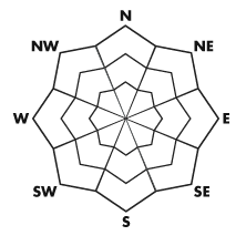
bottom line The Bottom Line for Sunday will be an Avalanche Danger of Considerable for wind slabs and storm slabs at all aspects and elevations in the La Sal Mountains, which received the Lion's share of the storm in southeast Utah. Natural avalanche activity is possible while human triggered avalanches are likely.
|
 |
special avalanche bulletin An additional 0.8" of H20 fell before midnight in the La Sal Mountains with plenty of strong winds that started off from the southwest and veered to the north this morning. 12" of snow fell at the Geyser Pass TH in the past 18 hours, increasing the avalanche danger to Considerable for storm snow and wind slabs. Sunday and Monday will be days to reevaluate the snow stability and distribution. Use these days for observations into avalanche terrain but keep off the throttle and stay safe. |
 |
current conditions The La Sal Mountains have received over 50 cm of powder the past four days in Gold Basin. Great riding conditions exist. Be prepared for touch and go driving conditions into the mountains today. 4WD and chains are recommended. |
 |
recent activity There were plenty of sluffs observed on steep slopes greater than 35 degrees yesterday on all aspects. I expect more today with the addition of some natural wind slab avalanche activity.
For those who would like to take a look at observations posted across the La Sal and Abajo Mountains, click HERE. Thank you to everyone that keeps contributing! |
| type | aspect/elevation | characteristics |
|---|
 |


Above treeline
Near treeline
Below treeline
|
|
|
description
More snow and wind equates to sensitive wind slabs. Cross loading was observed above treeline yesterday and will pose a threat as well today. Shooting cracks are a sign of instability. Avoid wind loaded areas and convex rollovers today. |
| type | aspect/elevation | characteristics |
|---|
 |


Above treeline
Near treeline
Below treeline
|
|
|
description
As the sun hits the slopes today, storm snow will start to sluff and may start slab avalanches. Today will be a good day for observing these types of avalanches. |
 |
weather Today: Scattered snow showers. Partly sunny, with a high near 21. Wind chill values as low as -10. Blustery, with a north wind 15 to 25 mph, with gusts as high as 35 mph. Chance of precipitation is 50%. Total daytime snow accumulation of 1 to 3 inches possible. |
| general annoucements The Friends of the La Sal Avalanche Center are an important partner to the Utah Avalanche Center-Moab. They assist by providing field observers, maintaining weather stations and purchase weather and safety equipment. Go to our partners website at www.moabavalanche.org to donate today. The Utah Avalanche Center-Moab is on Facebook! Get updates and advisories by becoming a friend today. |