Forecast for the Logan Area Mountains

Toby Weed
Issued by Toby Weed for
Thursday, February 29, 2024
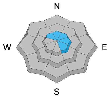
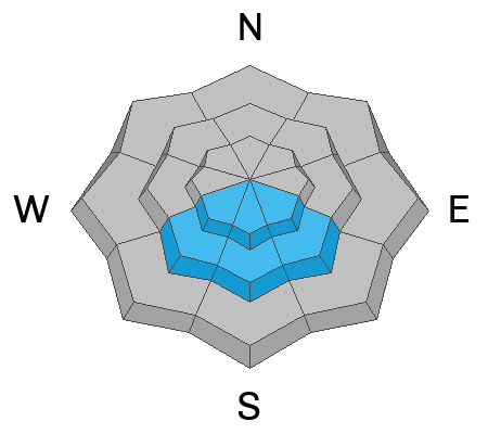
Areas with MODERATE danger exist in drifted upper and mid-elevation terrain where people could trigger avalanches of wind-drifted snow up to 2 feet thick on slopes steeper than 30°. Human-triggered cornice falls are likely. Warm temperatures and strong sun will create potential for loose wet avalanches of saturated surface snow on sunny slopes sheltered from the wind.
The best and safest powder riding conditions will be found in sheltered northerly facing terrain and on lower angled slopes.

Evaluate the snow and terrain carefully. Today, I plan to stay off and out from under steep drifted slopes, overhanging cornices, and sunny slopes with saturated surface snow.
Low
Moderate
Considerable
High
Extreme
Learn how to read the forecast here
Special Announcements
We are seeking a passionate individual to join us as Executive Director of the nonprofit Utah Avalanche Center. Click here for more information.
Weather and Snow
You can find nice powder conditions, especially in sheltered, north-facing terrain. The new snow is shallow at lower elevations, making it dust on crust. Yesterday's high-angled sun warmed the snow in sunny terrain, and the snow surface is probably a bit crusty today. Human-triggered avalanches of wind-drifted snow are possible where the strong westerly winds from earlier in the week drifted fresh snow and created 1 to 2-foot thick wind slabs stiffer than the nice powder. The winds also built out cornices, which can be devious and, if you get out on them, could fail much further back from the edge than expected. Drifting by increasing winds from the south today will continue to build overhanging cornices and create new wind slabs. Warm temperatures and strong sun will develop potential for loose wet avalanches on southerly slopes.
The Tony Grove Snotel at 8400' reports 25° F and 105 inches of total snow containing around 123% of normal SWE (snow water equivalent). I'm reading 82 inches at our new Card Canyon weather station at 8750', a bit north of Logan Peak.
Winds out of the south-southwest are increasing this morning at the CSI Logan Peak weather station at 9700' in elevation. They are currently blowing 28 mph with gusts around 37 mph. At our other new weather station at 9500' on Paris Peak, winds are also blowing from the south-southwest at 17 mph, and it's 19° F.

March will come in like a Lion this year. The National Weather Service has issued a Winter Storm Warning for the Logan Zone beginning late tonight and continuing through Saturday night. Today will be mostly sunny in the mountains with 8500' high temperatures around 37° F and 15 to 20 mph winds blowing from the southwest. Expect the winds to increase in the afternoon to 25 to 30 mph, with gusts pushing 50 mph. Winds out of the southwest will continue to increase tonight, gusting to around 55 mph, and snow will begin to fall after around 11:00, with 2 to 4 inches expected to accumulate by Friday morning.
Friday will be quite stormy, with periods of heavy snow and blowing snow. Winds howling from the southwest 28 to 37 mph, and gusts around 55 mph are expected, with mountain temperatures around 32° F, and 8 to 12 inches of accumulation possible in upper-elevation terrain during the day. Snowfall is expected to be heavy at times Friday night, with 10 to 16 inches of accumulation possible and winds continuing to blow strongly from the south-southwest.
It's the same thing on Saturday; the storm will continue, and snowfall will be heavy at times with periods of blowing snow. Winds blowing from the south-southwest with 13 to 19 inches of possible accumulation in the forecast. The frontal passage should occur around midday. Mountain snowfall will diminish a little on Saturday night, but it will continue to come through the weekend and well into next week.
Recent Avalanches
  • Yesterday, a snowbike rider triggered a soft wind slab in the Tony Grove Lake Area but was not carried. The location is not clear but it was on a north-facing slope at around 9000', reported as being 20" deep and 35' wide. (see report)
  • An observer noticed a recent wind slab avalanche in Logan Dry Canyon from Monday or Tuesday, 1 to 3' deep x ~200' wide, running ~1000' and crossing uptracks from the weekend. (see report)
  • Some natural cornice falls, and a few small wind slabs were observed yesterday morning in the Wellsvilles.
  • A good-sized natural avalanche was observed Monday morning at upper elevations in the Wellsville Range due to drifting by the strong prefrontal winds (report here).

Check out all local observations and avalanches HERE.
Ad
Avalanche Problem #1
Wind Drifted Snow
Type
Location
Likelihood
Size
Description
Human-triggered avalanches of wind-drifted snow are possible in drifted upper and mid-elevation terrain. Very strong winds from the west earlier in the week loaded snow onto leeward terrain and built out cornices. Watch for and avoid stiffer wind drifts on the lee side of major ridges, corniced slopes, and in and around terrain features like cliff bands, sub-ridges, gully walls, and mid-slope rollovers. Stiff wind slabs could be stubborn, allowing a person to get well out on them before releasing. Other softer wind slabs could be more sensitive; some might even be triggered remotely from a distance.
Avalanche Problem #2
Cornice
Type
Location
Likelihood
Size
Description
Stay well away from and out from under overhanging cornices, which may break further back than expected. Natural cornice falls are possible today, and some could trigger wind slab avalanches on slopes below.

Avalanche Problem #3
Wet Snow
Type
Location
Likelihood
Size
Description
Loose wet avalanches may become a problem in the warmth of midday in sunny terrain if the fresh snow becomes moist or slushy.
General Announcements
-Listen to your very own Logan Zone avalanche forecasters on the UAC Podcast HERE.
-Read my recent blog about wind, drifting, and avalanches HERE.
-Sign up for forecast region-specific text message alerts. You will receive messages about changing avalanche conditions, watches, and warnings...HERE.
-For all questions on forecasts, education, Know Before You Go, events, online purchases, or fundraising, call 801-365-5522.
-To report an avalanche or submit an observation from the backcountry, go HERE.
-Come practice companion rescue at the Franklin Basin TH Beacon Training Park. It's free and open to everyone. For easy user instructions, go HERE.
-We will update this forecast by 7:30 AM tomorrow.
This forecast is from the U.S.D.A. Forest Service, which is solely responsible for its content. This forecast describes general avalanche conditions, and local variations always occur.