Forecast for the Logan Area Mountains

Toby Weed
Issued by Toby Weed for
Tuesday, February 27, 2024
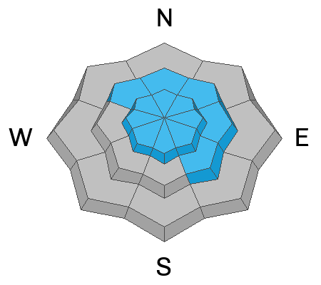
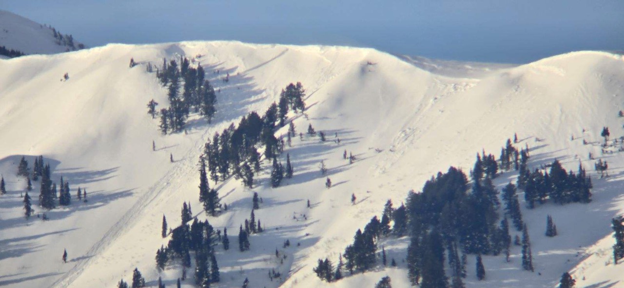
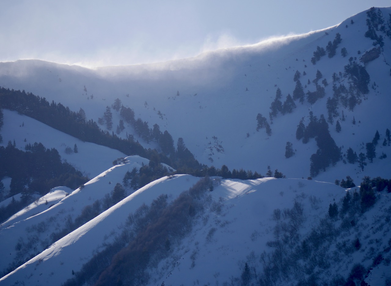
The avalanche danger is CONSIDERABLE in drifted upper and mid-elevation terrain, and extremely cold wind chill values will enhance the danger. Natural avalanches are possible, and human-triggered avalanches of wind-drifted storm snow and cornice falls are likely on slopes steeper than 30°. On some outlying east, south, and west-facing slopes, people might trigger large avalanches failing 2-3 feet deep on a thin, persistent weak layer. Elevated conditions also exist on drifted lower-elevation slopes. The best and safest powder riding conditions will be found in sheltered terrain and on slopes less steep than about 30°.
  • Careful snowpack evaluation, cautious route-finding, and conservative decision-making are essential for safe backcountry travel.
  • Avoid and stay out from under steep drifted slopes and overhanging cornices.
  • Dress warmly and keep tabs on your companions...
Low
Moderate
Considerable
High
Extreme
Learn how to read the forecast here
Special Announcements
We are seeking a passionate individual to join us as Executive Director of the nonprofit Utah Avalanche Center. Click here for more information.
Weather and Snow
Expect a cold powder day in the Logan Zone, but dangerous avalanche conditions exist in drifted terrain. The danger is heightened by cold temperatures and extreme wind chill values. On Beaver's webcams this morning, I can see that snow is still falling and the wind is still blowing. There's at least 9 inches of new snow on the snow stake. The big winner is the Franklin Basin ID Snotel, which is reporting 1.3" SWE (snow water equivalent) overnight. Less snow fell this time at lower elevations and in Cache Valley.

The Tony Grove Snotel at 8400' reports 10 inches of new snow overnight with 1 inch of SWE. I'm reading 10° F this morning, with 109" of total snow containing around 122% of normal SWE . After recording a 73 mph gust yesterday afternoon, winds came around from the northwest overnight, and they are still pretty strong at the CSI Logan Peak weather station. The wind is currently blowing from the west-northwest this morning around 22 mph with gusts to 45 mph. It's a chilly 2° F at 9700' in elevation, but the wind chill value is -20° F. At 9500' on Paris Peak, winds are blowing from the west-northwest at 15-20 mph, and it's also 2° F, with wind chill values ranging from -20° F to -18° F.

Snowfall and blowing snow will continue this morning but diminish in the afternoon, with 2" to 4" of additional accumulation possible. Skies will be mostly cloudy, with steady temperatures around 12° F at 8500' in elevation. Winds blowing from the west-northwest will continue to be fairly strong in the mountains and they will increase a notch this afternoon, with 30 to 35 mph average wind speeds and gusts in the 50 mph range expected. Wind chill values today will be as low as -13° F.
Tomorrow will be sunny with high temperatures around 29° F and 10 to 15 mph winds blowing from the west-southwest.
Snowfall is expected begin again in the mountains Thursday night, and it'll be heavy at times through the weekend, with significant accumulations possible.
Recent Avalanches
Some cornice falls and one good-sized natural avalanche were observed yesterday morning at upper elevations in the Wellsville Range due to drifting by the strong prefrontal winds.
Check out all local observations and avalanches HERE.
Ad
Avalanche Problem #1
Wind Drifted Snow
Type
Location
Likelihood
Size
Description
Human-triggered avalanches of wind-drifted snow and cornice falls are likely in drifted upper-elevation terrain. Very strong winds from the west have loaded snow onto leeward terrain and built out cornices. Watch for and avoid fresh wind drifts on the lee side of major ridges, corniced slopes, and in and around terrain features like cliff bands, sub-ridges, gully walls, and mid-slope rollovers. Some stiff wind slabs formed yesterday could be stubborn, possibly allowing people to get out on them before releasing, and these will be covered up and hidden by last night's fresh snow. Wind slabs and cornices will continue to build today as winds continue and increase again this afternoon. Some of these could be quite sensitive, with triggered avalanches likely and natural avalanches possible.
  • Soft slab avalanches of drifted storm snow are likely and may occur even in apparently sheltered terrain.
  • Stay well away from and out from under overhanging cornices, which may break further back than expected.
Avalanche Problem #2
Persistent Weak Layer
Type
Location
Likelihood
Size
Description
Some larger avalanches failing on a buried persistent weak layer are possible today on slopes overloaded by drifted snow. In some outlying terrain, on slopes generally facing the southern half of the compass (east through south through west), human-triggered avalanches could fail on a thin sugary or faceted persistent weak layer on top of a melt-freeze crust buried 2 to 3 feet deep.
  • The problem is more pronounced on sunny slopes, and avalanches could be highly consequential in certain terrain.
  • Audible collapses or whumpfs and shooting cracks are obvious signs of instability, but these red flags may not be present when avalanches occur.

Additional Information
A fresh natural avalanche of wind-drifted snow was observed yesterday morning in the Wellsville Range. It was likely triggered by cornice fall.
Winds were whipping yesterday and moving lots of snow in upper elevation terrain in the Wellsville Range.
General Announcements
-Listen to your very own Logan Zone avalanche forecasters on the UAC Podcast HERE.
-Read my recent blog about wind, drifting, and avalanches HERE.
-Sign up for forecast region-specific text message alerts. You will receive messages about changing avalanche conditions, watches, and warnings...HERE.
-For all questions on forecasts, education, Know Before You Go, events, online purchases, or fundraising, call 801-365-5522.
-To report an avalanche or submit an observation from the backcountry, go HERE.
-Come practice companion rescue at the Franklin Basin TH Beacon Training Park. It's free and open to everyone. For easy user instructions, go HERE.
-We will update this forecast by 7:30 AM tomorrow.
This forecast is from the U.S.D.A. Forest Service, which is solely responsible for its content. This forecast describes general avalanche conditions, and local variations always occur.