Forecast for the Logan Area Mountains

Toby Weed
Issued by Toby Weed for
Thursday, February 1, 2024
The danger is MODERATE in the Logan Area backcountry. Elevated avalanche conditions exist, and people might trigger dangerous slab avalanches failing on a persistent weak layer in rocky terrain with shallow snow and on slopes steeper than 30° with poor snow structure. Wet avalanches may become an issue if the surface snow is softened by warm temperatures or rain.

Evaluate snow and terrain carefully, especially in steep rocky areas with generally shallow snow, less than about 4 feet deep.
Low
Moderate
Considerable
High
Extreme
Learn how to read the forecast here
Special Announcements
Sign up for forecast region-specific text message alerts. You will receive messages about changing avalanche conditions, watches, and warnings...HERE.
Weather and Snow
Even though temperatures stayed above freezing last night up high, clear skies allowed for a decent surface refreeze, and the snow surface is crusty at all elevations. The snow in sunny terrain is supportable and smooth, and we found pretty good spring-like "corn" snow conditions yesterday morning in the Wellsville Range.

Wind blowing from the south increased significantly overnight, and this morning, the 9700' CSI Logan Peak weather station is recording average wind speeds of around 35 mph, and it's 31° F. At 9500' on Paris Peak, it’s 28° F, and winds are blowing around 10 mph from the south. The Tony Grove Snotel at 8400' reports 33° F and 71 inches of total snow containing 118% of average SWE (Snow Water Equivalent).

Today, expect high temperatures at 8500' around 36° F, with increasingly cloudy skies and winds blowing around 20 mph from the south. There is a good chance this afternoon of some snow up high and a bit of rain on mid and lower-elevation slopes, with little in the way of accumulation expected. The National Weather Service has issued a Winter Weather Advisory beginning this afternoon and continuing through Saturday. Snow is expected in the higher elevations tonight, with 1 to 3 inches of accumulation possible, winds blowing out of the southeast, and temperatures dropping to around 24° F. Rain is likely at low elevations. Snowfall will increase a bit on Friday, with 2 to 4 inches on upper-elevation slopes, winds veering from the west, and 8500' high temperatures around 31° F. Expect light snowfall to continue Friday night and Saturday with a few additional inches of accumulation possible.
Recent Avalanches
A natural wet loose and hard slab avalanche cycle occurred Sunday due to rapid warming. The wet activity mainly occurred on south-facing slopes at all elevations, and some large slab avalanches failed on the December persistent weak layer.
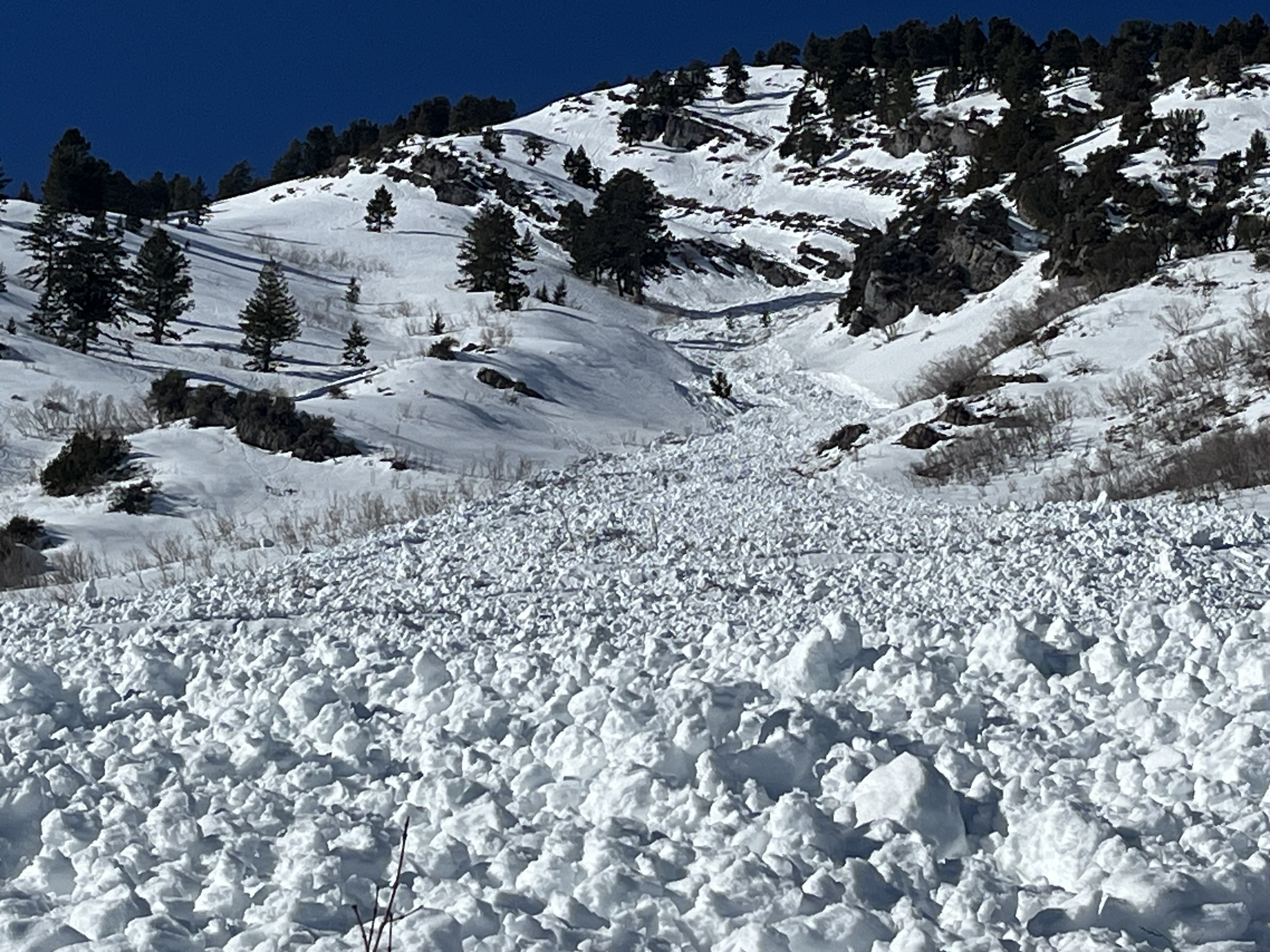
  • Evidence of a large natural wet avalanche was observed Tuesday on Mitton Peak in the Wellsville Mountain Wilderness. The avalanche, visible from Highway 89/91, started at around 8400' in elevation on a southeast-facing slope and ran around 2000 vertical feet.
  • A very large natural wet avalanche was witnessed by a professional observer in Green Canyon a little after noon on Sunday. see the report
  • A large avalanche on Wilderness Peak near Gibson Lakes in Franklin Basin was either naturally occurring or remotely triggered by riders on Sunday. It was reported on Monday by riders who noticed recent sled tracks in the area. report is here
Tuesday's wet avalanche on Mitton Peak entrained a large pile of heavy debris and ran around 2000 vrt'
Check out local observations and avalanches HERE.
Ad
Avalanche Problem #1
Persistent Weak Layer
Type
Location
Likelihood
Size
Description
Although increasingly unlikely, hard slab avalanches failing on a buried persistent weak layer could be large and life-threatening. In January, heavy snow and drifting overloaded slopes plagued by a widespread persistent weak layer that formed in the December dry spell. Rapid warming over the weekend caused some slopes to be unstable and there were a few large avalanches. Cooling today will increase snow stability, but dangerous avalanches are still possible in steep rocky terrain with shallow snow and poor snowpack structure, a stiff slab on top of a layer of weak, sugary, or faceted snow.
  • Avalanches still might be triggered remotely, from a distance, or even from below!
  • Audible collapsing (or whumpfs), cracking, and recent avalanches are obvious signs of instability. However, these red flags may not be present when avalanches failing on a persistent weak layer occur.

Avalanche Problem #2
Wet Snow
Type
Location
Likelihood
Size
Description
Rain on the snow at lower and mid-elevations and unseasonably warm temperatures may cause the snow to become saturated and unstable.
  • Roller balls, pinwheels, and loose wet avalanches or sluffs are signs that the snow is becoming unstable.
  • A smaller wet loose avalanche overrunning a slope with poor snow structure could initiate a much larger and more dangerous wet slab or hard slab avalanche.
Additional Information
General Announcements
Here is a short video from this weekend's large hard-slab avalanche on Wilderness Peak above Gibson Lakes in Franklin Basin, a few miles north of the UT/ID State Line.

-Read my recent blog about wind, drifting, and avalanches HERE
-Come practice companion rescue with your backcountry partners at the Franklin Basin TH beacon training park. video HERE.
-For all questions on forecasts, education, Know Before You Go, events, online purchases, or fundraising, call 801-365-5522.
-To report an avalanche or submit an observation from the backcountry, go HERE.
-I will update this forecast by 7:30 AM tomorrow.
This forecast is from the U.S.D.A. Forest Service, which is solely responsible for its content. This forecast describes general avalanche conditions, and local variations always occur.