Forecast for the Uintas Area Mountains

Issued by Craig Gordon for
Saturday, March 30, 2024
Saturday, March 30, 2024
Avy danger is straight-forward today, but look for changes to round out the weekend as yet another robust storm sets its sights on northern Utah-
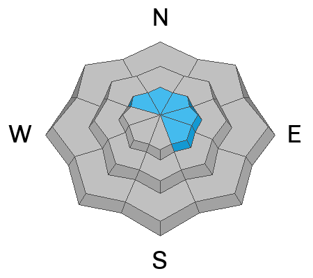
In the wind zone at and above treeline you'll find MODERATE avalanche danger. Human triggered avalanches are POSSIBLE on steep, wind drifted slopes, especially in terrain facing the north half of the compass, and particularly on slopes with an easterly component to their aspect.
Wind sheltered terrain at mid and low elevations offer LOW avalanche danger and human triggered avalanches are UNLIKELY.
Low
Moderate
Considerable
High
Extreme
Learn how to read the forecast here