Forecast for the Logan Area Mountains

Paige Pagnucco
Issued by Paige Pagnucco for
Tuesday, February 6, 2024
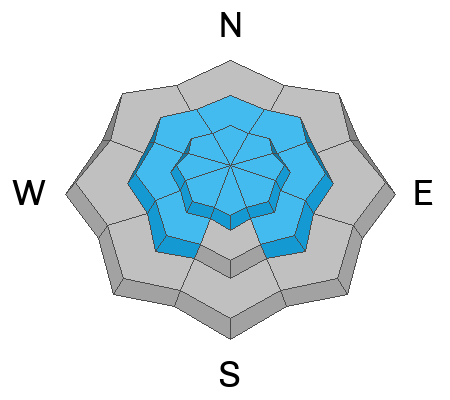
The avalanche danger is MODERATE today as strong winds blowing from the south have created fresh slabs of wind-drifted snow. Human-triggered avalanches are possible on steep slopes, mainly on the north half of the compass.

Evaluate the snow and terrain carefully as you travel in the mountains today.
Low
Moderate
Considerable
High
Extreme
Learn how to read the forecast here
Special Announcements
Want to learn more about how to stay safe from avalanches while riding in the backcountry? Join us Feb 23-24 for an Introduction to Avalanche class. Information and registration here.
Weather and Snow
The mountains picked up about 5-8" of new, dense snow yesterday continuing to smooth out last week's widespread crusty surface. Old tracks are disappearing, and the dense new snow is supportable. Today's best riding conditions are on sheltered low-angle slopes away from the wind, where the new snow is stacking up, and there's less chance to hit last week's crusty surface. On upper and mid-elevation slopes steeper than 30°, you could trigger wind slab avalanches of freshly drifted snow or soft slab avalanches of new snow. At low elevations, you may encounter wet avalanches on steep slopes with saturated snow.

The wind is blowing from the south-southeast this morning at 32 mph with gusts up to 50 mph at the 9700' CSI Logan Peak weather station where it's 25° F. On Paris Peak at 9500', it’s 24° F, and the wind is blowing 5 mph from the south. The Tony Grove Snotel at 8400' reports 29° F and received 5-8 inches of new snow in the last 24 hours with .8" SWE. The station reports 79 inches of total snow, containing 119% of the average SWE (Snow Water Equivalent).

Today, it'll be cloudy and mild in the mountains with a high at 8500' of 34° F and light snowfall. Winds are expected to temper and remain around 15-20 mph from the south. The next wave of moisture arrives this afternoon, and the mountains could get more than a foot of snow by Thursday morning. The temperatures will drop throughout the week with high's in the 20's F and lows in the single digits F by Thursday night into the weekend.
Recent Avalanches
No avalanches were reported yesterday.
Check out local observations and avalanches HERE.
Ad
Avalanche Problem #1
Wind Drifted Snow
Type
Location
Likelihood
Size
Description
Drifting of the new snow by strong southerly winds created wind slabs on the lee side of major ridges and in and around terrain features like sub ridges, gully walls, mid-slope roll-overs, and under cliff bands. You could trigger a wind slab avalanche on steep slopes mainly on the north half of the compass and even small avalanches of stiffer, wind-drifted snow could run fast and far on the slick crust formed during last week's warm temperatures.
  • Avoid recent drifts or wind slabs on steep slopes. Wind slabs are made up of stiffer, redeposited snow that may be more supportable than the surrounding powder. Lense-shaped drifts often make hollow, drum-like sounds.
  • Cracking is an obvious sign of wind slab instability.
  • Soft slab avalanches of new snow are possible on slopes steeper than 30 degrees.
  • An outlier at this point - hard slab avalanches failing on a buried persistent weak layer could be large and life-threatening. The weak, faceted snow that plagued the range in January is basically in the rear-view mirror but remains on the edges of our radar as we continue to find increasingly stubborn instability in our snow pit tests in areas with a shallower snowpack. Of note, red flags may not be present when avalanches failing on a persistent weak layer occur.
Avalanche Problem #2
Wet Snow
Type
Location
Likelihood
Size
Description
Rain saturated the low-elevation snowpack and you may encounter wet snow avalanches on steep slopes. If you sink deeply into the saturated snow, move to a cooler aspect or elevation.

Additional Information
On Sunday, we checked out the deposition from multiple large avalanches that occurred in January in Woodcamp. Though not historical in size, these slides laid out some pretty impressive debris piles.
General Announcements
-Read Toby's recent blog about wind, drifting, and avalanches HERE
-Sign up for forecast region-specific text message alerts. You will receive messages about changing avalanche conditions, watches, and warnings...HERE.
-For all questions on forecasts, education, Know Before You Go, events, online purchases, or fundraising, call 801-365-5522.
-To report an avalanche or submit an observation from the backcountry, go HERE.
-We will update this forecast by 7:30 AM tomorrow.
This forecast is from the U.S.D.A. Forest Service, which is solely responsible for its content. This forecast describes general avalanche conditions, and local variations always occur.