Forecast for the Logan Area Mountains

Paige Pagnucco
Issued by Paige Pagnucco for
Tuesday, February 20, 2024
A CONSIDERABLE danger exists in drifted, upper-elevation terrain, where people are likely to trigger avalanches of wind-drifted snow failing up to 2-3 feet deep on a thin, persistent, weak layer. Avoid steep slopes where snow is saturated from rain and/or warm temperatures. Today's best riding will be on upper-elevation, sheltered slopes less than 30°.

Careful snowpack evaluation, cautious route-finding, and conservative decision-making are essential for safe backcountry travel.
Low
Moderate
Considerable
High
Extreme
Learn how to read the forecast here
Special Announcements
We are seeking a passionate individual to join us as Executive Director of the nonprofit Utah Avalanche Center. Click here for more information.
Weather and Snow
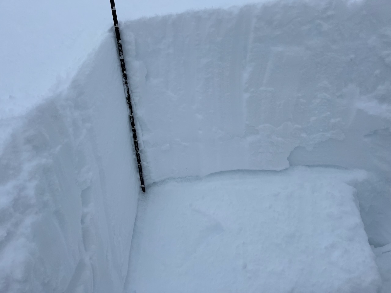
A warm, strong storm moved through the Logan area yesterday and overnight, dropping about 3-7 inches of heavy, dense snow across the zone. With yet another load of weight added, dangerous conditions still exist where wind-drifted snow has overloaded the old snow/new snow interface from 2/14. Riding conditions are good at higher elevations with colder temperatures, away from wind-affected areas. Today, your best option is high-elevation, sheltered terrain. Human-triggered slab avalanches up to 2-3 feet deep are likely on drifted upper-elevation slopes steeper than 30°.

The Tony Grove Snotel at 8400' reports .7" SWE (snow water equivalent) from yesterday, it's currently 28° F, and there is 102" of total snow (121% of normal). The wind is blowing from the west this morning in the 20's mph with gusts in the 30's mph at the 9700' CSI Logan Peak weather station. At 9500' on Paris Peak, winds from the southwest are blowing around 7 mph, and it's 22° F.

The next storm is rolling into Utah this morning but the narrow band is headed south of the Logan zone. While the mountains south of I-84 get clobbered with snow, rain, lightning, and thunder, we'll get just a few more inches of dense snow today with fairly mild winds. The National Weather Service's Winter Weather Advisory continues through tonight. 8500' temperatures will be about 35° F today with winds blowing from the southwest at 9 to 16 mph. Expect unsettled weather through Thursday morning, with a few more inches of snow possible. The skies clear Thursday and we'll have sun and warm temperatures Friday and Saturday, The next chance for snow is potentially Sunday.
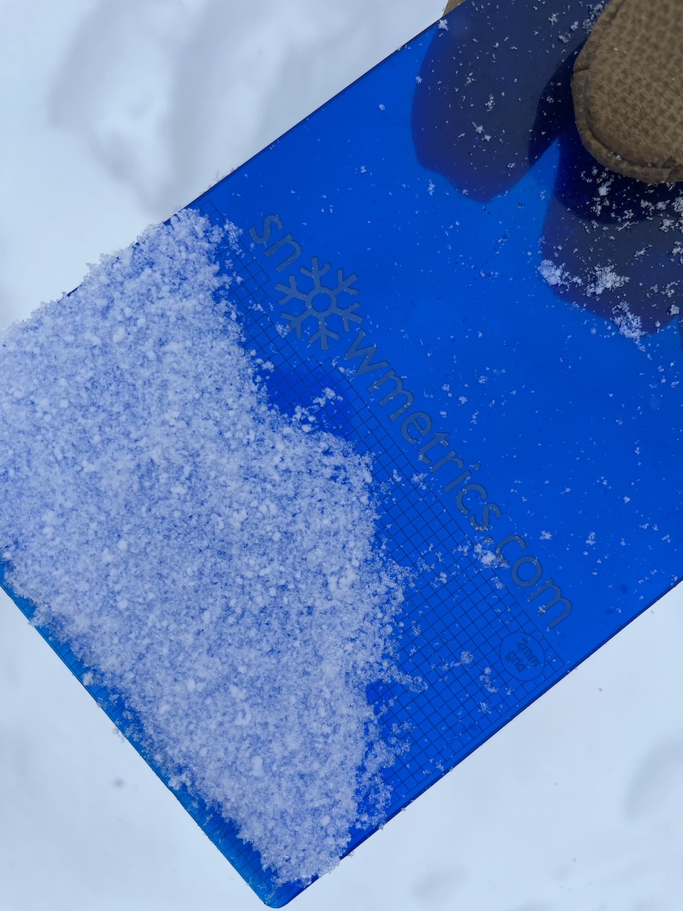
The buried layer of very small faceted grains from 2/14 is still easy to find but is becoming less reactive.
Recent Avalanches
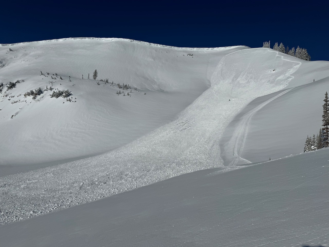
No avalanches were reported yesterday in the Logan zone but there was a fairly large natural avalanche just to our south on the east face of Ben Lomond on Sunday.
Check out local observations and avalanches HERE.
Ad
Avalanche Problem #1
Wind Drifted Snow
Type
Location
Likelihood
Size
Description
Drifting by winds mainly from the southwest has created stiff wind slabs in exposed upper-elevation terrain. Human-triggered avalanches of wind-drifted snow up to 2-3 feet deep on drifted slopes steeper than 30° are likely. These may be harder to identify today with a fresh covering of snow. Areas like the Wellsvilles and Woodcamp stand out as they have shallower snowpacks and tend to harbor wind-affected snow.
  • Watch for and avoid fresh wind slabs on the lee side of major ridges, corniced slopes, and in and around terrain features like cliff bands, sub-ridges, gully walls, and mid-slope rollovers.
  • Stay well away from and out from under overhanging cornices, which may break further back than expected.
  • Obvious signs of instability include cracking and collapsing, but these red flags may not be present when avalanches occur.
  • Soft slab and loose avalanches of new snow are possible even in more sheltered terrain.
Avalanche Problem #2
Persistent Weak Layer
Type
Location
Likelihood
Size
Description
Avalanches around 2-3 feet deep may fail on a thin layer of small-grained, sugary, or faceted snow that was on the snow surface on Wednesday, 2/14. This thin, persistent weak layer was buried by the productive storms over the past five days but is healing or gaining strength quickly. The best way to identify this layer and its reactivity is to get your shovel out, dig down a few feet, and perform an ECT. The problem is more pronounced in sunny terrain where the thin layer of faceted snow sits atop a supportable melt-freeze crust. I expect it to come off the forecast very soon.
Avalanche Problem #3
Wet Snow
Type
Location
Likelihood
Size
Description
Wet snow avalanches might be possible today, with warm temperatures and rain forecasted at lower elevations. Roller balls and pinwheels are signs of instability. If the snow you're on gets saturated, move to a cooler aspect and/or elevation.
*If you plan on fishing the Logan River today, be mindful of what's above you. Avoid standing under steep slopes where rain-soaked snow may slide down on top of you.
Additional Information
This avalanche in Three Terraces (upper Providence Canyon) was remotely triggered Saturday morning by a rider on a snowmobile.
We found a layer of small-grained, sugary snow at the interface of Wednesday's snow surface and Thursday's new snow. The "Valentines persistent weak layer (PWL)"
General Announcements
-Listen to your very own Logan Zone avalanche forecasters on the UAC Podcast HERE.
-Read my recent blog about wind, drifting, and avalanches HERE.
-Sign up for forecast region-specific text message alerts. You will receive messages about changing avalanche conditions, watches, and warnings...HERE.
-For all questions on forecasts, education, Know Before You Go, events, online purchases, or fundraising, call 801-365-5522.
-To report an avalanche or submit an observation from the backcountry, go HERE.
-Come practice companion rescue at the Franklin Basin TH Beacon Training Park. It's free and open to everyone. For easy user instructions, go HERE.
-Toby will update this forecast by 7:30 AM tomorrow.
This forecast is from the U.S.D.A. Forest Service, which is solely responsible for its content. This forecast describes general avalanche conditions, and local variations always occur.