AVALANCHE WARNING »
Dangerous avalanche conditions are occuring or are imminent.
Backcountry travel in avalanche terrain is not recommended.
|
 |
Notice:
THIS AVALANCHE WARNING IS FOR THE WASATCH MOUNTAINS NORTH OF I-80
INCLUDING THE BEAR RIVER RANGE OF NORTHERN UTAH THROUGH 8AM WEDNESDAY
FEB 18 2009.
HEAVY SNOWFALL AND MODERATE SOUTHWEST-WEST WINDS HAVE CREATED THE
POTENTIAL FOR WIDESPREAD NATURAL AVALANCHE ACTIVITY AND AVALANCHES
ARE LIKELY TO CONTINUE THROUGH THE WARNING PERIOD. PEOPLE WITHOUT
EXCELLENT AVALANCHE AND ROUTE FINDING SKILLS SHOULD AVOID
BACKCOUNTRY TRAVEL.
THIS WARNING DOES NOT INCLUDE SKI AREAS OR HIGHWAYS WHERE
AVALANCHE CONTROL IS NORMALLY DONE.
|
|
|
SPECIAL ANNOUNCEMENT |
 |
You can get a great deal on further discounted tickets to Beaver Mountain and support the Utah Avalanche Center at the same time. 100% of the funds raised from these donated lift tickets will go to the Friends of the Utah Avalanche Center and will help our financially strapped but important program...(Click HERE to get discounted tickets on-line) |
|
|
BOTTOM LINE
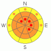
Danger by aspect and elevation on slopes approaching 35° or steeper.
(click HERE for tomorrow's danger rating)
|

Danger Rose Tutorial
|
(2-17-09 update)..... There is a CONSIDERABLE danger in the backcountry, and you could trigger dangerous storm snow or wind slab avalanches slopes steeper than around 35 degrees. Pockets with a HIGH danger may exist or develop with today's storm, mainly in terrain exposed to wind drifting at upper and mid-elevations. Triggered and natural avalanches are likely in these areas, especially in areas favored by a southwest flow that receive substantial deposits of additional heavy or drifted new snow today. A buried weak layer exists on some shady slopes and the danger of scary persistent slab avalanches is rising as accumulating and drifting snow slowly builds a slab on top of it. Today's storm could cause the danger of persistent slabs to rise quickly.
Travel in avalanche terrain is not recommended......Evaluate the snow and terrain carefully and use conservative decision making and wise travel protocols. |
|
|
CURRENT CONDITIONS |

|
The southern part of the Bear River Mountains, especially western slopes or the "front canyons," and the Wellsville Range picked up a good deal more snow than the mountains north of around Logan Canyon this weekend and over the last week.
The Tony Grove Snotel recorded about 9 inches of accumulation of light snow over the weekend, containing 1/2 of an inch of water, and there's 77 inches of total snow on the ground. The Campbell Scientific weather station on Logan Peak at 9700' reports 18 degrees this morning and a fairly strong southwest wind, consistently averaging around 30, with gusts in the 45 mph range.
The National Weather Service in Salt Lake City issued a Winter Storm Watch for the mountains of Northern Utah through Wednesday. Expect snowfall to begin later this evening with continuing strong southwesterly winds switching around from the west tomorrow. |
|
|
RECENT ACTIVITY |

|
We triggered a few harmless soft slabs on Saturday. In one case, I triggered a small fresh wind slab from the ridge top, and then ski cut out another older stiffer slab in the bed surface of the first. (photos) Without strong wind, the very soft, fresh slab avalanches didn't present much of a danger.
But, southwest winds picked up and so did avalanche activity yesterday, especially in the Central Wasatch Range, with numerous reports of triggered wind slab avalanches on drifted slopes. (Wasatch Advisory)
Of particular interest to me is one in the mountains above Bountiful, in which the slab layer reached a critical mass and the lurking weak surface hoar layer became reactive to human weight. (PHOTOS) |
|
|
THREAT #1 |

|
| WHERE |
PROBABILITY |
SIZE |
TREND |
|
|
|
|
| |
|
|
Over the next
24
hours.
|
|
|
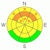
You could trigger dangerous storm snow or wind slab avalanches slopes steeper than around 35 degrees. Pockets with a HIGH danger may exist or develop with today's storm, mainly in terrain exposed to wind drifting at upper and mid-elevations. Triggered and natural avalanches are likely in these areas, especially in areas favored by a southwest flow that receive substantial deposits of additional heavy or drifted new snow today.
Fairly strong and sustained south winds caused dangerous wind slabs to develop over the holiday in exposed terrain and on many lee slopes. Drifting snow built out huge cornices, which have probably become dangerously sensitive. Southwest winds will continue and perhaps intensify a bit today... You should avoid steep slopes with recent deposits of wind drifted snow.... |
|
|
THREAT #2 |

|
| WHERE |
PROBABILITY |
SIZE |
TREND |
|
|
|
|
| |
|
|
Over the next
24
hours.
|
|
|
The storm on our doorstep might push this threat to the top of the list......
We've still been able to find a weak layer consisting of well preserved surface hoar or feathery frost crystals in many shady areas. (2/8/09 photo) This type of snow has a nasty reputation as a persistent weak layer that can lay hidden or non-threateningly in the snowpack for some time before a slab builds the right properties for it to become reactive. Because of their tricky nature, avalanches running on surface hoar account for most avalanche accidents in North America. The incoming storm might cause the slab and weak layer to reach this critical reactive state in more areas, and the danger of deadly persistent slabs is rising. |
|
|
THREAT #3 |

|
| WHERE |
PROBABILITY |
SIZE |
TREND |

|
|
|
|
| |
|
|
Over the next
24
hours.
|
|
|
The Central Bear River Range picked up much less snow over the last week, and with less soft snow available for the strong SW winds to drift, the danger is a bit lower north of about Logan Canyon to the Idaho State Line.
Expect the danger to rise significantly in the next couple days, with strong wind and heavy snowfall likely. |
|
|
MOUNTAIN WEATHER |

|
The National Weather Service in Salt Lake City issued a Winter Storm Warning for the mountains of Northern Utah through Wednesday. Expect additional heavy snowfall and stout winds becoming a bit more westerly today. Should see light snowfall continuing through tonight and showery conditions tomorrow. A high pressure system will build in on Thursday and set up for the weekend. |
|
|
GENERAL ANNOUNCEMENTS |
The Friends of the Utah Avalanche Center and the USU Outdoor Recreation Center are offering a four-day intensive advanced backcountry avalanche Level 2 (certification) class next weekend. The class starts on Thursday evening (2/19/09), and we'll spend the next 3 days in the field. Please call the ORC to register in advance. (435-797-3264)
Our "Know before You Go" video is available online..... (click HERE to watch it)
The UAC depends on contributions from users like you to support our work. To find out more about how you can support our efforts to continue providing the avalanche forecasting and education that you expect please visit our Friends page.
Your snow and avalanche observations help everyone in the backcountry community. Please let us know what you're seeing by leaving a message at (435-)755-3638 or 1-800-662-4140, or email us at uac@utahavalanchecenter.org. .
This advisory is from the U.S.D.A. Forest Service, which is solely responsible for its content. This advisory describes general avalanche conditions and local variations always occur.
I will update this advisory by around 7:30 Wednesday morning. |
|
|
This information does not apply to developed ski areas or highways where avalanche control is normally done. This advisory is from the U.S.D.A. Forest Service, which is solely responsible for its content. This advisory describes general avalanche conditions and local variations always occur. |
|
This advisory provided by the USDA Forest Service, in partnership with:
The Friends of the Utah Avalanche Center, Utah Division of State Parks and Recreation, Utah Division of Emergency Management, Salt Lake County, Salt Lake Unified Fire Authority and the friends of the La Sal Avalanche Center. See our Sponsors Page for a complete list. |
