Forecast for the Uintas Area Mountains

Mark Staples
Issued by Mark Staples for
Monday, April 1, 2024
Welcome to April with some pretty amazing conditions out there and tons of snow. Don't let your guard down because winds moved a lot of snow around yesterday. Conditions are pretty straight forward though - just stay off slopes loaded by recent winds and avoid terrain traps.
Today the avalanche danger above treeline is CONSIDERABLE where the most snow fell and winds blew the strongest. Triggering a slab of wind drifted snow is likely even though they may be getting stubborn today.
Near treeline the danger is MODERATE where you'll still want to avoid places with wind drifted snow.
Below treeline where less snow fell and winds didn't move much snow, the danger is LOW.
Low
Moderate
Considerable
High
Extreme
Learn how to read the forecast here
Special Announcements
Thank you to everyone who made a contribution to our spring fundraising campaign! We couldn't do this without your help.
Weather and Snow
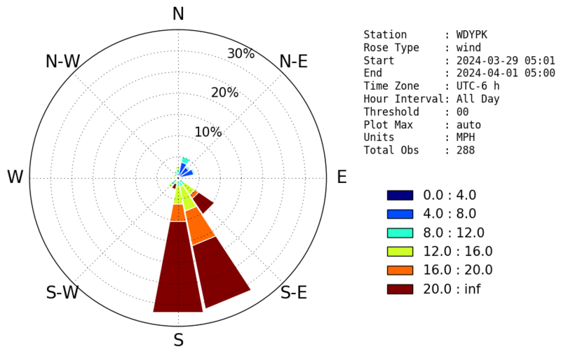
It was snowing and blowing yesterday, and an additional 3-6 inches of snow fell with a good increase in winds from the south. Southerly winds yesterday were blowing 25-40 mph gusting to 50 mph and moving a lot of snow. Over the last 6 days, 30+ inches of snow (4 inches of water) has been recorded at the Trial Lake SNOTEL.
This morning temperatures dropped into the teens F ranging from 13-18 degrees. Fortunately, winds decreased dramatically just after midnight and are barely blowing from the west this morning.
Today clouds will linger over the Uintas and the sun will poke through at times. Light snow will fall occasionally but not accumulate. Temperatures should climb into the upper 20s F, but it could feel quite warm if the sun appears for any length of time. Light winds will shift to the north this morning, and then increase to about 20 mph late this afternoon.
The rest of the week will be sunny and warm. Another storm should arrive next weekend, but at the moment it doesn't look like a ton of snow. We'll keep watching how it unfolds and keep our fingers crossed.

On upper elevation north facing slopes out of the wind, it's over the head and over the hood powder! Moments of sunshine and warm temperatures over the last five days have created several ice crusts. These are thicker and harder on southerly facing slopes and at low elevation slopes.

Photo from the northern part of the Uintas from Saturday (A. Gile)
Recent Avalanches
Yesterday in upper Weber Canyon, Craig spotted several soft slabs of wind drifted snow that happened naturally during an uptick in wind and snowfall. They were similar to one triggered by a rider on Friday near Hoyt Peak.
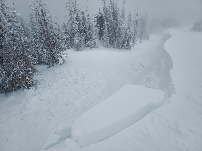
Winds have also created some huge cornices that were very sensitive yesterday. Uinta-ace, Mike J. found large cornices yesterday and was able to easily trigger them. He also saw that the adjacent slope had avalanched on its own.

For all Uinta observations and archived avalanche activity click HERE.
Ad
Avalanche Problem #1
Wind Drifted Snow
Type
Location
Likelihood
Size
Description
Strong south winds yesterday rapidly formed slabs of wind drifted snow. These wind slabs may be more stubborn and harder to trigger today, but I wouldn't trust them yet. They were sliding on their own yesterday; therefore, it's fair to assume a person could trigger them today. You will find them on the downwind side of any terrain feature where winds deposited snow either from the top or along the side.
Also, watch out for cornices along ridgelines. It's hard to know where the edge is sometimes. I had a close call back in February getting too close to a cornice. Don't trust them and stay far back.

The wind rose diagram below shows the distribution of wind speed and direction from the last 72 hours on Windy Peak.
Avalanche Problem #2
New Snow
Type
Location
Likelihood
Size
Description
Slopes untouched by the wind should have great powder, especially on northerly facing slopes, and instabilities in the new snow should be stabilizing quickly.
Don't let your guard down though, with so much snow there could easily be a pocket out there where a soft slab of new snow could avalanche. Stacks the odds in your favor by choosing terrain that has a clean runout and avoid steep slopes that end in terrain traps like a creek or gully or a wall of trees.
Additional Information
The Uinta weather station network was upgraded this summer and all that real-time info is found HERE. Simply click on "western Uinta" tab and then "weather stations" tab.

We are always looking for snow and avalanche observations or just general riding conditions. So... if you see something, say something. You can reach me directly at [email protected] or 801-231-2170.
Also, if you're looking for more avy education opportunities for yourself, your crew, or your club please don't hesitate to reach out to me and we'll find a presentation, class, or clinic for ya!
General Announcements

Issued at 0700 on Monday, April 1st this forecast will be updated by 0700 Tuesday, April 2nd, 2024.
This forecast is from the U.S.D.A. Forest Service, which is solely responsible for its content. This forecast describes general avalanche conditions and local variations always occur.