Forecast for the Uintas Area Mountains

Craig Gordon
Issued by Craig Gordon for
Wednesday, February 28, 2024
Sunny skies and fresh pow beg us to stomp on the accelerator, but today we should continue pumping the brakes-
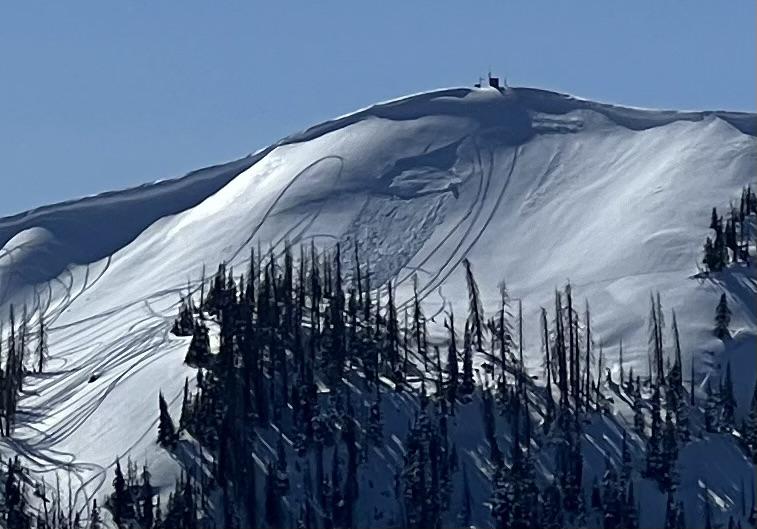
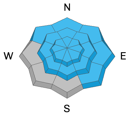
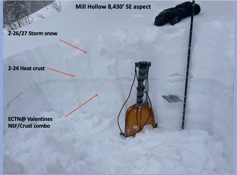
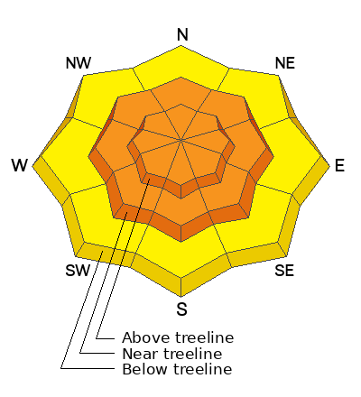
At and above treeline you'll find CONSIDERABLE avalanche danger. Human triggered avalanches are LIKELY around the dial, especially in the wind-zone where you'll encounter fresh drifts reactive to our additional weight. Becoming more the exception than the rule, we can still trigger a deep, dangerous slide that breaks to the ground in steep, rocky terrain facing the north half of the compass.
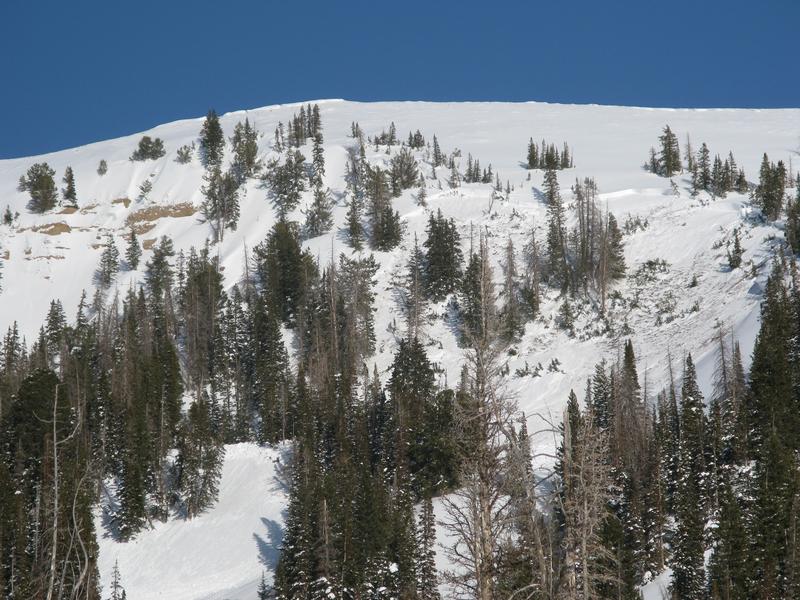
Storm snow, coupled with strong winds create fresh drifts which dot the lower elevation landscape. You'll find MODERATE avalanche danger and human triggered avalanches are POSSIBLE on steep, wind drifted slopes at lower elevations near our trailheads.

Here's your exit strategy-
Not feelin' it today? Well then, you came to the right place, cause the Uintas offer tons of mellow terrain less than 30 degrees in steepness where you can have an absolute blast and avoid the avalanche dragon.
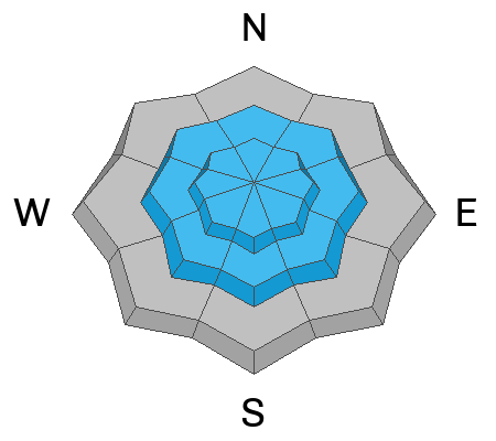
Low
Moderate
Considerable
High
Extreme
Learn how to read the forecast here
Special Announcements
We are seeking a passionate individual to join us as Executive Director of the nonprofit Utah Avalanche Center. Click here for more information.
Weather and Snow
Nowcast- Wow... if our stock portfolio performed like yesterday's storm, we'd be considering an early retirement... yeah, what an over-producer! Winds were all over the place, but when I crunch the numbers, 12" of snow with .90" H20 seems about right. Skies are clear this morning as arctic air filters into the region, delivering some of the coldest temperatures of the winter. The mercury is slow to wake up and nudge past the goose egg laid overnight. The good news is... yesterday's gale force winds finally abated late last night and currently blow 15-25 mph from the west and southwest. Windchill is still rather brutal near the high peaks where temperatures register to -20 degrees. Of course, you'll quickly forget about your numb toes and little red nose when the snows fly over-da-hood and over-da-head!
Forecast- High pressure builds rapidly and we'll see mostly sunny skies with temperatures rebounding quickly, climbing into the low 30's by late afternoon. Winds blow from the west and southwest and get a little rowdy near the high peaks, clocking in at speeds of 20-30 mph. Overnight lows dip into the teens.
Futurecast- Thursday is another stunner, but winds will spoil the powder party late in the day. We change gears and transition back to storminess late Friday through the weekend with another robust shot of snow, water, and wind.
Spring is... well it's springing! And our good friend and partners at Salt's Lake National Weather Service confirm my hypothesis in the graphic above :)

SNOTEL sites in the Uintas, and much are Utah, report snow water equivalent amounts of 104%-146% of the 30 year median.
Recent Avalanches
From Sunday... not exactly breaking news, but a great image of a sledder triggering a deep wind drift near Currant Creek Peak.
In addition, on Saturday my crew and I in upper Chalk Creek remotely triggered a large avalanche that broke to the ground, up to 10 feet deep and 350 feet wide. We triggered the nasty slide from a distance, a few football fields away, on an adjacent low angle slope.
For all Uinta observations and recent avalanche activity click HERE.
Ad
Avalanche Problem #1
Persistent Weak Layer
Type
Location
Likelihood
Size
Description
Chad and his partners skied in upper Weber Canyon this weekend where they described it as a "tale of two snowpacks". While most areas they traveled in offered a deep snowpack, one adjacent slope was shallow with only three feet of total snow, and it was in this thin spot they initiated the largest collapse they had ever experienced. It produced cracks shooting 150 feet from them.... a mini avalanche! (viddy above).
Here's where it gets tricky... the odds of triggering an avalanche breaking to older snow near the ground are markedly different from one slope to the next, so ya gotta give this some thought. Sure, much of our terrain offers a deep and relatively strong snowpack and triggering a monster slide is unlikely, while other slopes, especially those that have remained thin and weak this season are likely suspects and need to be avoided. Terrain that has avalanched multiple times and slopes that have been stripped by strong winds fit into this category.
Avoiding this avalanche dragon is the ticket, but ya gotta do your homework and identity terrain with shallow snow. Notice the rocky area in the left side of the photo of this avalanche. Steep rocky zones are likely trigger points because they offer a much thinner snowpack.
Avalanche Problem #2
Wind Drifted Snow
Type
Location
Likelihood
Size
Description
A 24 hour data dump from Windy Peak (10,662') illustrates recent wind and temperature trends.
Yesterday's winds were all over the map, whipping up fresh drifts in unusual locations and lower downslope than we expect to see. Found mostly on the leeward side of ridges and around terrain features like chutes and gullies, both old and newer drifts will react to our additional weight. This is an easy avalanche problem to avoid... lose the wind and you lose the problem. Simply dump some elevation and steer your snow vehicle towards wind sheltered terrain where you'll find deep, cold snow.
Avalanche Problem #3
New Snow
Type
Location
Likelihood
Size
Description
The jury is still out on the Valentines Day NSF/Crust combo and I need to investigate a little more before putting this layer to bed. However, in my lower elevation travels yesterday, I found this layering unreactive and comfortable in its own skin.
February's storm track is the gift that keeps giving, stacking up multiple feet of snow on top of several weak layers. The storm snow is settling and becoming a cohesive slab that helps tie things together. Now, take that combo onto a steep slope and the recipe for a slab avalanche is coming together. The only missing ingredient is us.
Here's where it gets tricky... on the south half of the compass, sunny slopes have a thin layer of facets on top of a crust that was buried 12"-18" deep on Valentine's day. This layer delivered two avalanches in Mill Hollow last Tuesday and Wednesday. In American Fork Canyon on Thursday, this layer produced a huge avalanche and a close call.
In addition, shaded slopes harbor buried surface hoar now buried about three feet deep. And while it hasn't produced avalanches, it'll be something to keep and eye on.
Additional Information
The Uinta weather station network was upgraded this summer and all that real-time info is found HERE. Simply click on "western Uinta" tab and then "weather stations" tab.

We are always looking for snow and avalanche observations or just general riding conditions. So... if you see something, say something. You can reach me directly at [email protected] or 801-231-2170.
Also, if you're looking for more avy education opportunities for yourself, your crew, or your club please don't hesitate to reach out to me and we'll find a presentation, class, or clinic for ya!
General Announcements

Issued at 0330 on Wednesday, February 28th this forecast will be updated by 0700 Thursday, February 29th, 2024.
This forecast is from the U.S.D.A. Forest Service, which is solely responsible for its content. This forecast describes general avalanche conditions and local variations always occur.