Support the UAC website backend platform to ensure the ongoing security of the website and the data stored on the site rebuild by
donating to our spring campaign. Skies are clear.
But not for long. We'll see increasing high clouds as a hint of things to come.
The winds from the south picked up overnight, blowing 25-30mph with gusts to 40. Even some unobstructed mid-elevation ridgeline anemometers are registering hourly averages of 25-30mph.
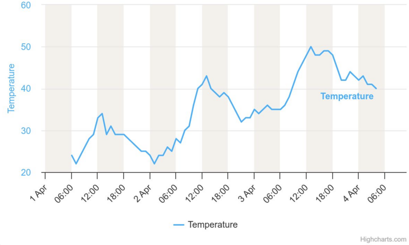
Mountain temperatures remain sweltering with another night of a poor refreeze, if that. Overnight "lows" in the mid to high 30s are again 5-10° warmer than 24 hours ago, which were 10-15° warmer than the night before. (Note Mill D North (elev. 8961') temperatures below. The diurnal temperatures swings are obvious, but so is the trend. Many total depth snow stakes lost 4-6" in the last 24 hours alone.
For today, we'll have increasing high clouds and possibly some greenhousing. Winds from the south will blow 30-40mph with gusts to 50+. Temperatures will rise to the mid-50s down low, the mid-40s up high. We *may* experience another dust event if the winds present more of a southwesterly direction. It won't be pretty.
We'll have another night of warm temperatures tonight ahead of tomorrow afternoon's cold front and extended snowfall through the weekend. The model runs have trended
snowier with each run...and many areas will pick up 8-12" of snow and perhaps 12-18" in areas that benefit orographically from a west-southwest flow. It does look like the winds remain brisk through Sunday. This should be a decent storm for us and did I mention McKinley Talty's essay,
Do We Let Our Guard Down in the Spring?
Wet avalanches: With skyrocketing temperatures and direct sun, wet avalanches again cascaded down the steepest sunlit terrain yesterday, leaving impressive debris piles. Those overstaying their welcome on these sunlit slopes by midday also found it easy to trigger wet loose avalanches and it paid off to move out of the fall line to avoid the cement mixer.
Don't underestimate the power of wet avalanches. See Connor Worth's footage of a natural slide out of White Pine couloir on the north side of LCC.
Check out all avalanches and observations
HERE.