Forecast for the Moab Area Mountains

Dave Garcia
Issued by Dave Garcia for
Monday, March 25, 2024
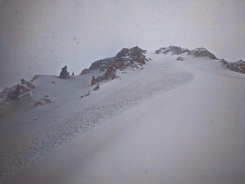
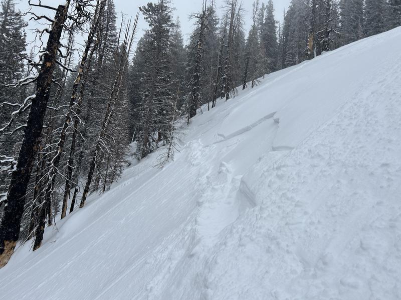
The overall avalanche danger is MODERATE. Your primary concern today is soft slabs of wind-drifted snow that will be sensitive to the weight of skiers and riders. Fresh drifts will be found on all aspects above treeline, and near treeline on slopes that face NW-N-NE-E.
The new snow is poorly bonded to hard slick crusts on many slopes, and dry-loose avalanches and shallow soft slab avalanches in the new snow are possible in steep terrain.
Low
Moderate
Considerable
High
Extreme
Learn how to read the forecast here
Special Announcements
Road Conditions: The Geyser Pass Road is not plowed and you will find about 6" of snow on the road. 4x4 and good tires are recommended.
Grooming: Ben groomed on Sunday

Support the UAC website backend platform rebuild to ensure the ongoing security of the website and the data stored on the site rebuild by donating to our spring campaign. Save lives by making a donation today! HERE
Weather and Snow
6:00 a.m. Snow and Weather Data
24 Hour Snow 8" 72 Hour Snow 8" Season Total Snow 176" Depth at Gold Basin 65"
Winds on Pre-Laurel Peak: NW 8-11 Temp 17° F Percent of Normal: 125%

Weather
Unsettled Northwest flow will keep temperatures below normal with chances for light snow showers lingering through today and tomorrow. This morning, under cloudy skies, it is 17 degrees in Gold Basin. It will feel like winter up there today, with high temperatures around 20 degrees. Winds will blow 20-30 mph out of the NNW. Light snow showers may give us another 1-3 inches of snow by tomorrow. This system will move out Tuesday night, and Wednesday will be mostly sunny. Below normal temps will hang on through mid-week with a warming trend into the weekend. The next storm looks to impact the area late this weekend into early next week.
General Conditions
The mountains got a much needed refresh yesterday, and we found great skiing and riding in sheltered, northerly, mid-elevation terrain yesterday. Be sure to check out Charlie's report of our day in Corkscrew Glades. Travis Nauman and company got up a bit higher, and reported blowing and drifting snow, small natural avalanches, and great skiing in north facing terrain. Be sure to read their report here. The Gold Basin SNOTEL is reporting 0.7" of SWE. Yesterday the snow totals seemed to be dependent on elevation, with more snow up high. A couple of inches trickled in after the closing bell, and totals are around 6 to 9 inches across the range. Your primary avalanche concern today is soft slabs of wind-drifted snow near treeline and above. The winds will continue to blow and drift snow today and fresh slabs will continue to form.
Snowpack and Weather Data
Gold Basin Storm Stake (10,000')
Gold Basin SNOTEL site (10,000')
SNOTEL site near Geyser Pass Winter Trailhead (9600')
Wind Station on Pre-Laurel Peak (11,400')
NWS forecast for the La Sal Mountains.
Recent Avalanches
Travis Nauman and his party watched this natural avalanche involving wind-drifted snow come down out of the chute above Lone Pine. Skier-triggered slides of similar size and depth remain possible today.
My party triggered this small soft slab avalanche involving the new snow in Corkscrew Glades
Ad
Avalanche Problem #1
Wind Drifted Snow
Type
Location
Likelihood
Size
Description
With more than 6" of new snow available for transport, Moderate winds out of the Northwest will have no trouble blowing and drifting snow into sensitive soft slabs. Look for reactive drifts near and above treeline today. Last week's string of warm, sunny weather left a variety of slick crusts on most aspects. These slick crusts make great bed surfaces, and because of this, I anticipate the recent wind slabs to be particularly sensitive.
The new snow is also poorly bonded to these slick crusts. Yesterday we experienced sluffing in steep terrain, and I would expect more of the same today. In isolated areas, the new snow is cohesive enough to fail as a soft slab avalanche. It is possible to trigger shallow soft slabs involving the new snow in steep terrain today.
Additional Information
Want some more insight into the La Sal Mountains as well as the communal impacts of a tragic avalanche? Check out the latest UAC podcast with forecaster Eric Trenbeath where he discusses the range, it's often treacherous snowpack, and how the devastating avalanche in February, 1992, affected the Moab community.
Our avalanche beacon checker sign and beacon training park are up and running. A huge thanks to Talking Mountain Yurts for sponsoring those this season!
Sign up for forecast region-specific text message alerts. You will receive messages about changing avalanche conditions, watches, warnings and road plowing closures.
Follow us on Instagram @utavy_moab
General Announcements
This forecast is from the U.S.D.A. Forest Service, which is solely responsible for its content. This forecast describes general avalanche conditions and local variations always occur.