Forecast for the Moab Area Mountains

Eric Trenbeath
Issued by Eric Trenbeath for
Thursday, February 29, 2024
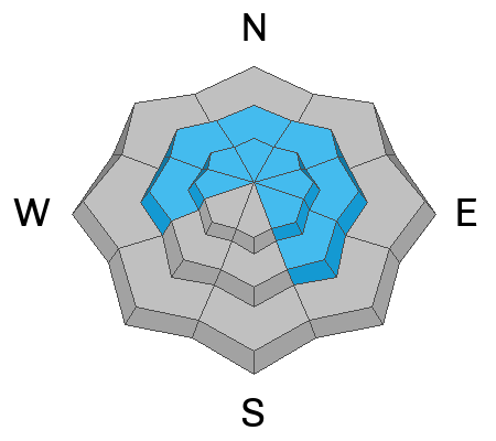
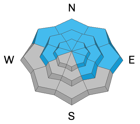
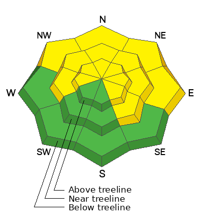
The avalanche danger is MODERATE. Human triggered avalanches involving stiff slabs of wind drifted snow are possible on steep slopes facing W-N-SE. Look for slabs of wind drifted snow on the leeward sides of ridge crests and terrain features such as gully walls, sub-ridges, and rocky outcrops.
A MODERATE danger remains for human triggered avalanches failing on a deeply buried persistent weak layer, also on slopes facing W-N-SE. The danger is most pronounced on steep, northerly aspects. You can minimize your risk by avoiding steep, rocky areas and slopes with complex terrain features.
A mostly LOW danger exists on S-SW aspects. Small avalanches on isolated terrain features are possible.
Low
Moderate
Considerable
High
Extreme
Learn how to read the forecast here
Special Announcements
We are seeking a passionate individual to join us as Executive Director of the nonprofit Utah Avalanche Center. Click here for more information.
Road Conditions: The Geyser Pass Road is not plowed, expect to find a few inches of snow on top of a slick surface.
Grooming: Gold Basin was packed out yesterday.
Weather and Snow
6:00 a.m. Snow and Weather Data
24 Hour Snow 0" 72 Hour Snow 3" Season Total Snow 135" Depth at Gold Basin 50"
Winds on Pre-Laurel Peak: SW 15-25 Temp 24° Percent of Normal: 98%

Weather
We'll see sunny skies and warm temperatures for the next couple of days but March is poised to roar in like a lion. SW winds will be on the rise again tonight and will continue to increase through Saturday when they could reach speeds over 50 mph. A cold front and associated low pressure system will move through Saturday night that will hopefully bring us a decent shot of snow on Sunday. Northern Mountains are favored. Unsettled weather continues into next week.
General Conditions
Recreation Program Manager Brian Murdock took a tour into Gold Basin yesterday and reported finding a wind ravaged landscape. Winds have been all over the compass, and a shift to the N on Tuesday night really did a number on things. You're going to have to seek out the most sheltered terrain to find soft snow today. He also reported some natural wind slab releases in random locations. Up to a foot deep, they weren't particularly wide or well connected, but you'll need to remain on the lookout for them today. Suspect smooth, rounded deposits that sound or feel hollow underneath. There remains a low likelihood, high consequence risk for triggering a deep avalanche failing on weak, faceted snow near the ground. Keep the odds in your favor by avoiding steep, rocky, complex terrain.
Wind affected snow in the alpine. PC Brian Murdock.
Snowpack and Weather Data
Gold Basin Storm Stake (10,000')
Gold Basin SNOTEL site (10,000')
SNOTEL site near Geyser Pass Winter Trailhead (9600')
Wind Station on Pre-Laurel Peak (11,400')
NWS forecast for the La Sal Mountains.
Recent Avalanches
Brain Murdock reported this small wind slab release on a W aspect in the bottom of the Funnel. This random, cliffy terrain feature near treeline or slightly below managed to catch enough drifted snow to produce an avalanche. This is the type of feature that could cause you problems in more consequential terrain.
Ad
Avalanche Problem #1
Wind Drifted Snow
Type
Location
Likelihood
Size
Description
Shifting winds over the past few days have blown and drifted snow into slabs on a variety of aspects and elevations. Not particularly wide or well connected, they may however, pop up just about anywhere, particularly on slopes facing W-N-SE. Look for them on the leeward sides of ridge crests and terrain features such as gully walls, sub ridges, or rocky outcroppings. They may also be further down slope than you expect. They'll be stiff and stubborn to release today but think about the consequences - even a small release could sweep you off your feet and carry you over a cliff or into trees.
Dave Gracia snapped this pic of wind transported snow off the peaks on Tuesday.
Avalanche Problem #2
Persistent Weak Layer
Type
Location
Likelihood
Size
Description
The likelihood of triggering an avalanche on a deeply buried PWL continues to decrease, but it is still possible. We are now in a low likelihood, high consequence scenario. If you are stepping out into avalanche terrain, evaluate each slope on an individual basis. Aim to ride in areas with a deep snowpack. Avoid steep, rocky terrain, thinner areas along slope margins, and steep, blind rollovers or convexities. These are all likely trigger points.
If you happen to be poking around in alpine terrain, and you were to trigger a slab of wind-drifted snow, it could step down to the persistent weak layer, causing a much larger and more dangerous avalanche.
Additional Information
Want some more insight into the La Sal Mountains as well as the communal impacts of a tragic avalanche? Check out the latest UAC podcast with forecaster Eric Trenbeath where he discusses the range, it's often treacherous snowpack, and how the devastating avalanche in February, 1992, affected the Moab community.
Our avalanche beacon checker sign and beacon training park are up and running. A huge thanks to Talking Mountain Yurts for sponsoring those this season!
Sign up for forecast region-specific text message alerts. You will receive messages about changing avalanche conditions, watches, warnings and road plowing closures.
Follow us on Instagram @utavy_moab
General Announcements
This forecast is from the U.S.D.A. Forest Service, which is solely responsible for its content. This forecast describes general avalanche conditions and local variations always occur.