Forecast for the Logan Area Mountains

Toby Weed
Issued by Toby Weed for
Friday, March 22, 2024
The avalanche danger is LOW this morning, but with very warm mountain temperatures expected again, it could rise to MODERATE in some places during the day. Natural wet avalanches, cornice falls, and glide avalanches may become possible.
If you start sinking into melt-softened saturated snow, plan to move to lower-angled terrain. Avoid and stay out from under large overhanging cornices.
Low
Moderate
Considerable
High
Extreme
Learn how to read the forecast here
Special Announcements
Donate today to help us rebuild our website backend platform to ensure uninterrupted access to avalanche information and the ongoing security of the website and the data stored on the site.
The Utah Avalanche Center is hosting The Banff Film Festival on Thursday, March 21, and Friday, March 22 in Moab. Click here for tickets and information.
Weather and Snow
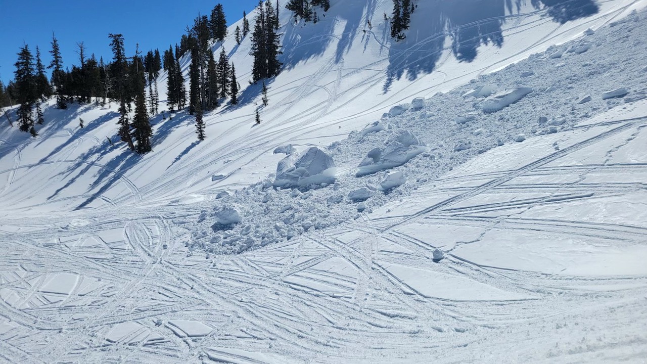
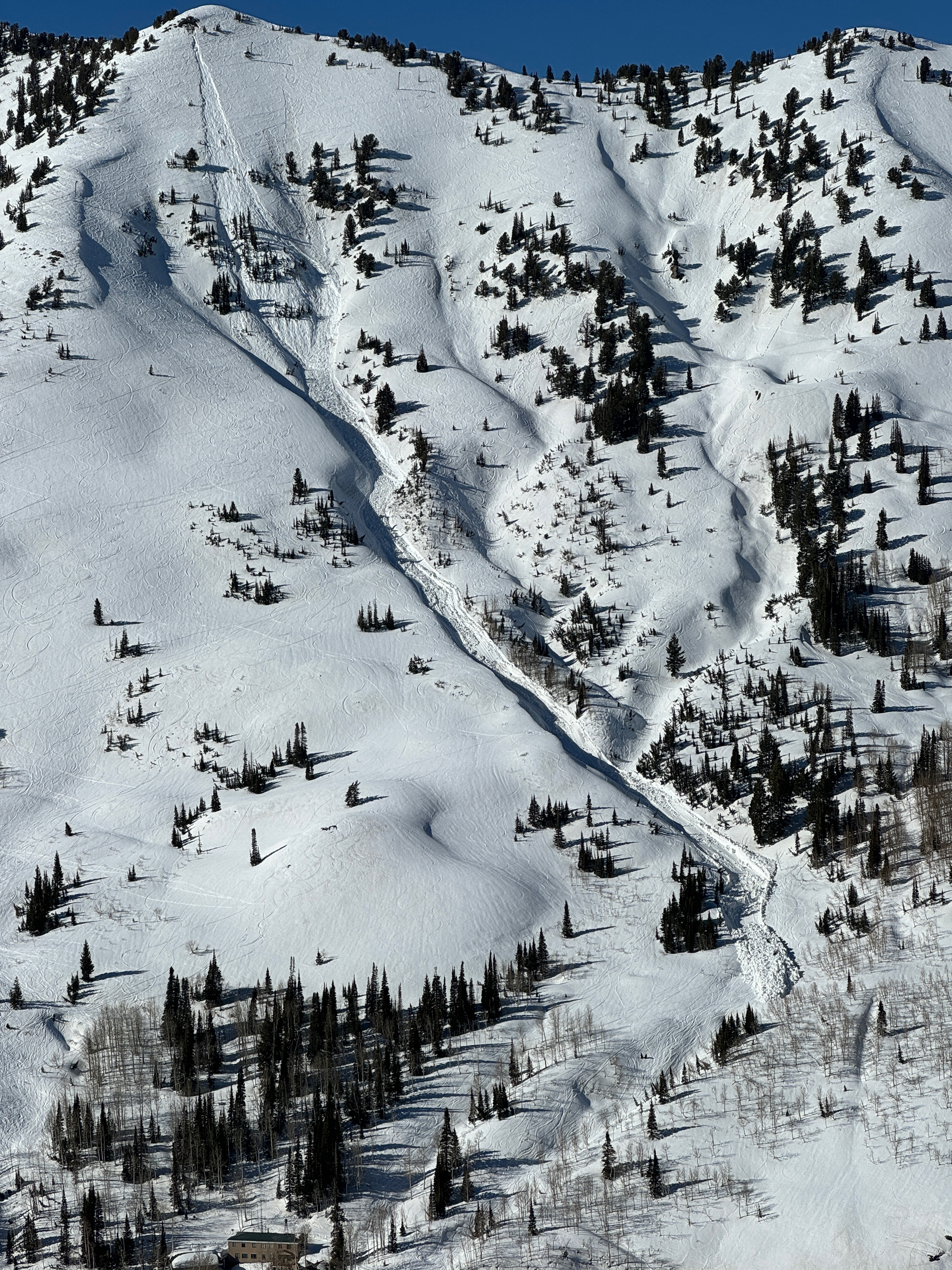
The melt water in the snow appears to be draining well and it's generally stable in most places. The Leap Day/ March 1 dust layer has melted back onto the snow surface at low and mid elevations, and observers report variable and crusty conditions. People might find nice spring "corn snow" on select slopes for a short window of time in the morning, but heightened wet avalanche conditions may develop on some slopes in the midday heat.

It's 35 °F this morning at the 8400' Tony Grove Snotel at 5:00 AM, and there is 94 inches of total snow containing 119% of normal snow water equivalent (SWE). On Logan Peak, winds are blowing from the west-northwest around 20 mph, and it's 27 ° F at 9700' in elevation.
At the new Paris Peak weather station at 9500', it's also 27°F, and the wind is from the west-northwest, blowing 20 to 25 mph, with gusts near 40 mph. I'm reading 27° F at the new Card Canyon weather station at 8800', with 81" total snow.

Today will be sunny and high temperatures at around 8500' in elevation will rise to around 44° F. Winds will blow from the west at 8 to 16 mph. Hopefully, mountain temperatures will drop below freezing tonight, with an expected low temperature of around 28° F. It will be mostly cloudy with a good chance of snow showers, but little in the way of accumulation is expected.
Snow showers are expected tomorrow with a high temperature around 43° F and increasing winds from the south-southwest blowing 16 to 25 mph, with gusts near 40 mph. 1 or 2 inches could accumulate on upper-elevation slopes in the afternoon.
Snow showers will continue Saturday night and Sunday, with 3 to 7 inches of accumulation possible in upper-elevation terrain.
Recent Avalanches
A large natural cornice fall occurred Tuesday, around noon, off the Grandfather Cornice, Cornice Ridge, south of Naomi Peak. No other avalanches were reported recently.
Large overhanging cornices threaten steep slopes below, like this one off Grandfather Cornice in the Central Bear River Range. (S. Titensor 3-19-24)

Check out all local observations and avalanches HERE.
Ad
Avalanche Problem #1
Wet Snow
Type
Location
Likelihood
Size
Description
We are moving into the time of year when it's best to get an early start and then move off steep slopes before the saturated snow gets too soft.
  • If you start seeing signs of unstable snow like roller balls or pinwheels or you sink deeply into the damp snow, it's time to leave or move to a cooler aspect or elevation. Or, you can head for slopes or meadows less steep than 30°.
  • Natural glide avalanches are possible anytime but most likely during the day's heat on steep slopes with smooth ground surfaces or a rock slab beneath the season's snow.
Avalanche Problem #2
Cornice
Type
Location
Likelihood
Size
Description
Avoid being on slopes capped by large overhanging cornices that may calve or collapse due to the heat. Large natural cornice falls are possible, and these could trigger wet avalanches on slopes below.
Additional Information
A good-sized natural avalanche occurred at around 3:00 Wednesday afternoon across from Alta in Little Cottonwood Canyon.
General Announcements
-National Forest Winter Recreation Travel Maps show where it's open to ride: UWCNF Logan, Ogden LRD Tony Grove, Franklin Basin CTNF Montpelier
-Listen to your very own Logan Zone avalanche forecasters on the UAC Podcast HERE.
-Read Toby's blog about wind, drifting, and avalanches HERE.
-Sign up for forecast region-specific text message alerts. You will receive messages about changing avalanche conditions, watches, and warnings...HERE.
-For all questions on forecasts, education, Know Before You Go, events, online purchases, or fundraising, call 801-365-5522.
-To report an avalanche or submit an observation from the backcountry, go HERE.
-Come practice companion rescue at the Franklin Basin TH Beacon Training Park. It's free and open to everyone. For easy user instructions, go HERE.
-We will update this forecast tomorrow by 7:30 AM.
This forecast is from the U.S.D.A. Forest Service, which is solely responsible for its content. This forecast describes general avalanche conditions, and local variations always occur.