Forecast for the Provo Area Mountains

Issued by Brooke Maushund on
Saturday morning, January 3, 2026
Saturday morning, January 3, 2026
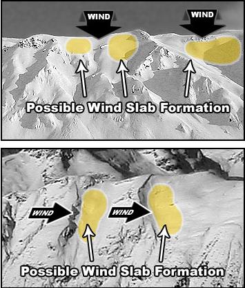
The avalanche danger is MODERATE on W-N-E facing slopes above 9500' where the wind has drifted new, dense snow into slabs. These avalanches have the potential to run far and fast on the slick crust below. Smaller wind slabs may prove effective triggers for deeper, destructive slides on a persistent weak layer up to 100 feet wide. Steep, rocky, wind-exposed northerly slopes are most suspect.
If the sun comes out for long periods or the temperatures rise more than forecast today, expect the possibility of being able to move small panels of wet new snow.

Low
Moderate
Considerable
High
Extreme
Learn how to read the forecast here