SPECIAL ANNOUNCEMENT |
 |
Our fourth annual Avy Ride, a fundraiser benefitting avalanche outreach and education specifically for snowmobilers, will be held Saturday Feb. 26th. You can get more details by clicking here. |
|
|
BOTTOM LINE
Danger by aspect and elevation on slopes approaching 35° or steeper.
(click HERE for tomorrow's danger rating)
|
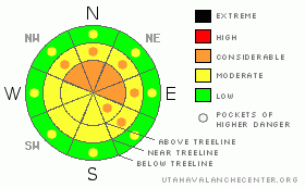
Danger Rose Tutorial
|
The current avalanche hazard is Level 3 (Considerable), potentially deep wind slabs exist on NW, N, NE & E facing slopes at both mid & upper elevations.
A widespread persistent slab exists throughout the range & has a Level 3 (Considerable) hazard associated with it. Those without expert snow assessment skills should avoid upper elevation slopes facing NW, N, NE & E. Triggering an avalanche in the buried surface hoar will result in a large and destructive avalanche. The hazard will increase as the next storm enters the region Thursday. |
|
|
CURRENT CONDITIONS |

|
We received 19" of snow out of the last storm system that has settled out to a nice 14". Needless to say the riding is currently excellent. The mercury has slunk down to the single digits at upper elevations where winds are blowing out of the WSW at 20 mph. Low elevation temps are in the mid teens. |
|
|
RECENT ACTIVITY |

|
It's been an active last few days. Early in the storm natural avalanches began releasing & there was a very close call on Friday that involved six sledders & a human triggered avalanche on the North Slope. No injuries were reported although a few sleds had to be towed out after being damaged by the slide. As the weekend progressed we went through a natural avalanche cycle that saw crowns up to 3' in depth.
Big thanks to all those who submitted observations. The information is GREATLY appreciated! |
|
|
THREAT #1 |

|
| WHERE |
PROBABILITY |
SIZE |
TREND |

|
|
|
|
| |
|
|
Over the next
72 hours.
|
|
|
A number of professionals commented on the wind transported snow yesterday. It's no wonder; we've got nearly two feet of light fluffy storm snow and winds blasting out of the S - SW. Big winds like this can really move snow: today you could certainly go out and find trophy sized wind slabs. I wouldn't be surprised to see wind slabs taller than I am on steep north through east facing terrain. Avoid fat pillow like features and stay in tune with how the snow feels under your machine. Light & fluffy is great, dense and hollow means wind slab. Do your best to stay off the later.
Remember that today's wind slabs are only half the story. We've got another storm moving in tomorrow that will stick with us for a few days. This one's got the potential to leave us with another few feet of snow which will further exacerbate the wind slab hazard. |
|
|
THREAT #2 |

|
| WHERE |
PROBABILITY |
SIZE |
TREND |
|
|
|
|
| |
|
|
Over the next
72 hours.
|
|
|
The Uintas are truly a very big place. With so much activity on the North Slope as of late, Craig and I were curious what was happening elsewhere. So yesterday we went out surface hoar (SH) hunting and found the 010811 SH to be prevalent everywhere we dug. Not only did we find the old SH, we also found a new & sensitive SH layer buried 1.5' below the snow surface. That's what makes the current situation so tricky. You can ride some slopes 'till their tracked out and then bump over to a new bowl and Wham, the wheels come off the bus as you trigger a large destructive avalanche. Without expert snow assessment skills your best bet is to avoid steep north through east facing terrain.
Look for the avalanche danger to bump up as the approaching storm begins to unleash its fury Thursday through Saturday. |
|
|
MOUNTAIN WEATHER |

|
In the mountains today you're likely to see partially cloudy skies and the occasional snow flurry as high's approach 25 F. Tomorrow a large low pressure system begins to creep it's way across Utah. This system will persist through the weekend has the potential to bring several feet of snow to the Uintas. It looks like the most intense snowfall will occur Friday into early Saturday. This makes the weather forecast pretty simple really: Prepare for storm day riding beginning tomorrow. Dry your gear out every night because you're going to need it in tip top condition to stay comfortable out there over the next few days. Expect highs in the 20's and lows in the single digits as this storm system has its way with our forecast area. |
|
|
GENERAL ANNOUNCEMENTS |
The information in this advisory expires 24 hours after the date and time posted, but will be updated by 7:00 AM Saturday, Feb. 26th, 2011.
If you’re getting out and about and trigger an avalanche or see anything interesting please let us know here. Or drop Craig an email : craig@utahavalanchecenter.org or call 801-231-2170
The western Uinta advisory program is going full tilt and forecasts will be issued by 7:00 AM on Wednesday, Saturday, Sunday and all holidays. |
|
|
This information does not apply to developed ski areas or highways where avalanche control is normally done. This advisory is from the U.S.D.A. Forest Service, which is solely responsible for its content. This advisory describes general avalanche conditions and local variations always occur. |
|
This advisory provided by the USDA Forest Service, in partnership with:
The Friends of the Utah Avalanche Center, Utah Division of State Parks and Recreation, Utah Division of Emergency Management, Salt Lake County, Salt Lake Unified Fire Authority and the friends of the La Sal Avalanche Center. See our Sponsors Page for a complete list. |
