SPECIAL ANNOUNCEMENT |
 |
Both Mirror Lake Highway and Wolf Creek Pass are currently drivable, though regular winter maintenance has come to an end. Don't let this easy access to the western Uintas lull you into a false sense of security just because you can see your car from a nearby ridge or mountain top. The Uinta snowpack is notoriously sketchy and quite a bit weaker than you might find in the central Wasatch. If you're getting into steep terrain, be prepared for your own self rescue- that means wear and know how to use an avalanche beacon, shovel and probe.
Also, I will be giving a free avalanche awareness presentation geared specifically for snowmobilers today at 2:00 at Tri-City Performance in Centerville. |
|
|
BOTTOM LINE
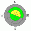
Danger by aspect and elevation on slopes approaching 35° or steeper.
(click HERE for tomorrow's danger rating)
|
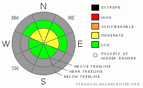
Danger Rose Tutorial
|
In upper elevation terrain facing the north half of the compass a MODERATE avalanche danger exists and human triggered avalanches will be possible, especially on steep, wind drifted slopes. In wind sheltered terrain the avalanche danger is generally LOW. |
|
|
CURRENT CONDITIONS |

|
A cool and somewhat moist northerly flow over the region is producing a few clouds and a stray snow flurry or two. Currently, west and northwesterly winds are blowing 15-25 mph along the high ridgelines and temperatures are in the upper teens at 10,000’ and mid 20’s at the trailheads. Riding and turning conditions are limited to upper elevation terrain, but soft settled powder on a mostly supportable base will be found on northerly facing slopes. |
|
|
RECENT ACTIVITY |

|
A few shallow wind slabs ran naturally is steep terrain the past few days. Click here for recent observations. |
|
|
THREAT #1 |

|
| WHERE |
PROBABILITY |
SIZE |
TREND |
|
|
|
|
| |
|
|
Over the next
24 hours.
|
|
|
While most upper elevation terrain only has about 24”-30” of total snow on the ground our snowpack is off to a banner start. The dense snow that fell in October combined with a supportable crust or two is holding its own and maintaining strength in all but the high elevation, shady north facing slopes.Click here for Bald Mountain snow profile and here for Murdock Bowl snow profile
For the moment, two main concerns exist. First- there’s light fluffy snow available to blow around and as winds increase, drifting along the high ridges may become an issue. While some of these drifts will be shallow and easy to trigger there’s a few stiffer slabs that may be harder to detect and more stubborn, but will pack a bigger punch once initiated. In addition, winds have been swirling around along the high peaks, cross loading chutes, gullies and sub-ridges. In either case, play it safe and avoid any recently wind drifted slope.
Secondly- the snowpack is still quite shallow and while you might not get buried, triggering a slide this early in the season is going to result in a body bruising and possibly season ending injury. |
|
|
MOUNTAIN WEATHER |

|
Today we can expect a mix of clouds and sun with a passing snow shower or two, though accumulations will be negligible. Winds could be an issue along the high ridges throughout the day, blowing 15-25 mph with a few gusts near 40 mph. Today’s high temperatures are expected to reach into the upper 20’s at 8,000’ and low to mid 20’s at 10,000’. Overnight lows dip into the mid teens. The weather pattern remains the same the next couple of days with no real defined storm systems, though several waves embedded in the northwest flow will bring periods of light snowfall to our region through midweek. Looking into the future, a larger storm system is expected to develop for next weekend. |
|
|
GENERAL ANNOUNCEMENTS |
The information in this advisory expires 24 hours after the date and time posted, but will be updated by 7:00 AM Saturday November 20th.
If you’re getting out and about and trigger an avalanche or see anything interesting please drop me an email at craig@utahavalanchecenter.org or call 801-231-2170
Also, now is a great time to schedule one of our free avalanche awareness presentations for your group or club. Email or call me and we’ll get you booked before things get too crazy. |
|
|
This information does not apply to developed ski areas or highways where avalanche control is normally done. This advisory is from the U.S.D.A. Forest Service, which is solely responsible for its content. This advisory describes general avalanche conditions and local variations always occur. |
|
This advisory provided by the USDA Forest Service, in partnership with:
The Friends of the Utah Avalanche Center, Utah Division of State Parks and Recreation, Utah Division of Emergency Management, Salt Lake County, Salt Lake Unified Fire Authority and the friends of the La Sal Avalanche Center. See our Sponsors Page for a complete list. |
