SPECIAL ANNOUNCEMENT |
 |
Huge thanks to Brandon Fry, Paul Jensen, Cade Beck, Darce Trotter & Steve Cote for their awesome observations this week! User observations make for better forecasts which help to save lives. Your obs are always welcome & appreciated!
|
|
|
BOTTOM LINE
Danger by aspect and elevation on slopes approaching 35° or steeper.
(click HERE for tomorrow's danger rating)
|
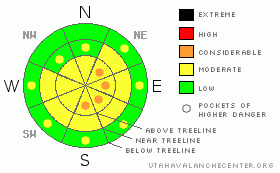
Danger Rose Tutorial
|
At and above treeline the avalanche danger is generally Level 2 (Moderate). Sustained winds have created wind slabs on nearly every aspect. There are pockets of Level 3 (Considerable) avalanche danger where you will find the most recent wind slabs to be the most sensitive to the weight of a rider. Evaluate big open terrain carefully, especially slopes that show signs of recent wind loading.
|
|
|
CURRENT CONDITIONS |

|
The Sunday/Monday storm laid down about 5" of light density snow on the Skyline. Strong N & NE winds have wreaked havoc on the new snow in most locations but savvy riders will find great boondocking conditions in sheltered locations. The frigid Arctic air is a thing of the past; temperatures are in the low twenties across the region this morning accompanied by moderate winds out of the N-NE.
|
|
|
RECENT ACTIVITY |

|
Poking around yesterday we came across this nice Size 2 avalanche just above Millers Flat Reservoir. This wind slab pulled out naturally after continuous wind loading. It was also interesting to find this glide crack in Seeley Canyon.
|
|
|
THREAT #1 |

|
| WHERE |
PROBABILITY |
SIZE |
TREND |
|
|
|
|
| |
|
|
Over the next
72 hours.
|
|
|
5" of very light density cold smoke powder fell early in the week. The winds have been downright abusive, throwing the snow this way and that. We've had sustained winds out of the W, NW, NE, N & E. Windslabs are widely distributed across the range, and many are in places where you wouldn't usually find them. Remember that wind slabs often have a fat pillow like look to them, and they feel stiff under the machine.
This is when small test slopes really become important, because the energy in wind slabs is usually short lived. But, it can be hard to tell which ones are fresh, and which ones have been sitting for a few days. By tweaking small test slopes, you can get a good idea of how the bigger slopes may behave. The best test slopes are on the same aspect and near the same elevation as the bigger slopes you want to ride & are low consequence if it does side.
Continue to watch for wind loading and avoid slopes with fresh wind deposited snow.
|
|
|
MOUNTAIN WEATHER |

|
A series of storms is expected to hit the mountains of Northern Utah over the next four days, but unfortunately, it looks like we're going to miss out on most of the action. You can expect mostly cloudy skies and nice moderate temperatures if you're headed out today. Saturday & Sunday present mostly cloudy skies with intermittent flurries but accumulations aren't expected to total more than an inch. Temperatures cool as a cold storm system impacts the area at the start of the workweek.
|
|
|
GENERAL ANNOUNCEMENTS |
See or trigger an avalanche? I'd like to hear about it! You can reach me on my cell phone: 801-824-0305 or shoot me an email: grant (at) utahavalanchecenter (dot) org Observers may choose to remain anonymous if they wish.
This forecast will be updated by 7:00am Friday February 11th.
Click here for a refresher on the Avalanche Danger Scale. |
|
|
This information does not apply to developed ski areas or highways where avalanche control is normally done. This advisory is from the U.S.D.A. Forest Service, which is solely responsible for its content. This advisory describes general avalanche conditions and local variations always occur. |
|
This advisory provided by the USDA Forest Service, in partnership with:
The Friends of the Utah Avalanche Center, Utah Division of State Parks and Recreation, Utah Division of Emergency Management, Salt Lake County, Salt Lake Unified Fire Authority and the friends of the La Sal Avalanche Center. See our Sponsors Page for a complete list. |
