BOTTOM LINE
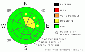
Danger by aspect and elevation on slopes approaching 35° or steeper.
(click HERE for tomorrow's danger rating)
|
Danger Rose Tutorial
|
Potentially dangerous avalanche conditions exist due to a persistent weak layer at the ground. High and mid elevation slopes that see more shade than sun during the day have a MODERATE avalanche hazard. (Those that face N, NE & E.) All other slopes have a LOW avalanche hazard. But, remember, low avalanche hazard DOES NOT mean no avalanche hazard. Ride slopes one at a time, watch your partners and don't forget, there's at most three and half feet between you and terra firma. |
|
|
CURRENT CONDITIONS |

|
Like hungry Pirhanas we devoured the prize that was the New Years eve storm snow. Most of the popular play areas are tracked out at this point.
On my field day I ran into an old foe; the dreaded rain crust. Wednesday's turbulent little system layed down a translucent ice crust. This layer now caps the snowpack and is quite widespread. While not a player at the moment, it will be as time marches on. We'll be watching this new crust cloesely to see how it interacts with future storm systems. |
|
|
RECENT ACTIVITY |

|
The wind picked up early in the week and formed shallow wind slabs on unprotected N- NE aspects. A few of these wind slabs failed naturally. These were size 1 avalanches & pockety in nature. |
|
|
THREAT #1 |

|
| WHERE |
PROBABILITY |
SIZE |
TREND |
|
|
|
|
| |
|
|
Over the next
24
hours.
|
|
|
I know, I'm starting to sound like a broken record. Every forecast issued this month has talked about a persistent slab. Why is this? Well, I think my boss (Bruce Tremper) says it best:
"Depth hoar behaves like a stack of champagne glasses. Although it's stronger in compression than shear, it can also fail in a catastrophic collapse of the layer. Fractures often propagate long distances and around corners. Almost all catastrophic, climax avalanches (involving the entire season's snow cover) occur on depth hoar."
Yep, it's nasty stuff, and it's still sensitive to a medium trigger. While It's getting harder to trigger this layer, if you do, it will be catastrophic. The cold temperatures have been rotting our snowpack, but, now that it's warming up, our slab is gaining cohesive strength. You know the places to be weary of; wind loaded (lee) slopes that are steep and rocky. Particularly watch areas that appear "fat" (look for pillows) and/or have stiff feeling snow. |
|
|
MOUNTAIN WEATHER |

|
High pressure remains anchored over all of Utah. Partly cloudy, mostly sunny, it doesn't matter what you call it, it means that we're not getting any snow any time soon. The TV guys will likely talk about snow next week, but, it's just a few weak disturbances moving through that are unlikely to produce more than a few flakes. |
|
|
GENERAL ANNOUNCEMENTS |
See or trigger an avalanche? I'd like to hear about it. You can reach me on my mobile: 801-824-0305, or shoot me an email: grant@utahavalanchecenter.org Observers may choose to remain anonymous if they wish.
I will update this forecast by 7am Saturday January 16th. |
|
|
This information does not apply to developed ski areas or highways where avalanche control is normally done. This advisory is from the U.S.D.A. Forest Service, which is solely responsible for its content. This advisory describes general avalanche conditions and local variations always occur. |
|
This advisory provided by the USDA Forest Service, in partnership with:
The Friends of the Utah Avalanche Center, Utah Division of State Parks and Recreation, Utah Division of Emergency Management, Salt Lake County, Salt Lake Unified Fire Authority and the friends of the La Sal Avalanche Center. See our Sponsors Page for a complete list. |
