SPECIAL ANNOUNCEMENT |
 |
We are updating this advisory only on an intermittent basis as conditions warrant. The next advisory will likely be on Friday. |
|
|
BOTTOM LINE
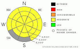
Danger by aspect and elevation on slopes approaching 35° or steeper.
(click HERE for tomorrow's danger rating)
|
Danger Rose Tutorial
|
I expect MODERATE danger of storm snow (new snow and wind slabs) within the 6-16 inches of new snow from today's storm. These will be sluffs, soft slabs and wind slabs. Be sure to jump on test slopes to see how well the snow is bonded to the old snow surface.
We will like have a lingering MODERATE danger or wet sluffs and slabs especially at lower elevations where both the new snow and old snow has remained damp or wet. Also, if we see some sun it will cause a spike in wet activity on sun exposed slopes. |
|
|
CURRENT CONDITIONS |

|
Yippee it worked! Usually when I bad-mouth the snow conditions and talk about lack of snow, it snows a foot. Alta is up to 21 inches from the storm as of Friday morning. Most other places got 5-10" with a couple more overnight. OK, so we won't get the record for the lowest snow year on record, but we got some great snow, which is the better end of the deal.
The snow was dense and fell on a very wet snow surface. At lower elevations, the old snow was completely saturated and punchy.
Remember you can always check the automated weather stations, snow amounts and forecast at the Snow Page. |
|
|
RECENT ACTIVITY |

|
Salt Lake mountains: One person was injured in an avalanche they triggered on the south face of Superior. They were able to get themselves down to the road without any assistance. We don't know any other details. At the resorts there were sensitive soft slabs, with slope cuts and explosives in a.m.Very wet old snow surface. One full depth slab 2-3' x 60' in thin area, east facing, 9,000’.Elsewhere, a little bit slabby with low energy.
Park City side: numerous wet slides 8-14\" deep, running 60-200ft on old sun crust. Snow pack is fully saturated and punchy to the ground.Nice cornice up high and long running loose snow slides packing a punchSki cuts in AM produced long running sluffs. Sluffs ran on crust from wet snow surface from yesterday.
Ogden area mountains: 6-10" soft slabs on ski cuts, along upper ridges.Failing on new/old snow interface, sluffs running on graupel within storm snow.Moderate, with pockets of Considerable.
Remember you can always check for observations coming in every day on our Current Conditions page. |
|
|
THREAT #1 |

|
| WHERE |
PROBABILITY |
SIZE |
TREND |

|
|
|
|
| |
|
|
Over the next
24 hours.
|
|
|
With the high precipitation intensity especially this morning, the new snow was quite cranky. The storm will give us a break for the next few days but remain cloudy and unsettled with light snow showers. So the new snow should settle out quite a bit by Friday. You will likely find lingering soft slabs or wind slabs, especially along the upper elevation ridges. Remember that the snow is quite thin on the south facing slopes so the new snow will cover up plenty of rocks.
Note: the grey areas on the danger rose above indicate bare ground. |
|
|
THREAT #2 |

|
| WHERE |
PROBABILITY |
SIZE |
TREND |

|
|
|
|
| |
|
|
Over the next
24
hours.
|
|
|
There was a lot of rain and wet snow during the first part of the storm with fairly warm temperatures, so the old snow remained saturated and punchy especially at lower elevations. There were quite a few wet sluffs and slabs today. I'm guessing that with a lull in the precipitation, they will settle out fairly quickly by Friday, but stay on the lookout for wet or moist snow, both within the new snow and the old, pre-existing snow. As always, avoid steep slopes when they are soggy. Also, we will probably not see much sun today but IF the sun comes out, it will quickly make wet sluffs and some slabs on the steep, sun exposed slopes of all elevations. |
|
|
MOUNTAIN WEATHER |

|
Most of the storm is headed to southern Utah and Arizona but we will be left with cloudy, unsettled weather without too much snow accumulation. We should get about 4 additional inches of snow on Friday with perhaps that much more on Friday night. Ridge top temperatures should be in the 20's tonight and in the mid 30's on Friday with winds from the south at 20 mph.
We should get another small shot of snow on Saturday night into Sunday, then a few more pulses of moisture mid week through the end of the week.
Since this is an intermittent advisory, you can check the weather anytime you want at the following handy links:
Cottonwood Canyons forecast (updated twice per day)
Graphical weather forecast(updated 4 times per day) |
|
|
GENERAL ANNOUNCEMENTS |
If you trigger an avalanche in the backcountry - especially if you are adjacent to a ski area – please call the following teams to alert them to the slide and whether anyone is missing or not. Rescue teams can be exposed to significant hazard when responding to avalanches, and do not want to do so when unneeded. Thanks.
Salt Lake and Park City – Alta Central (801-742-2033)
Ogden – Snowbasin Patrol Dispatch (801-620-1017)
Provo – Sundance Patrol Dispatch (801-223-4150)
Dawn Patrol Forecast Hotline, updated by 05:30:888-999-4019option 8.
Twitter Updates for your mobile phonehttp://utahavalanchecenter.org/twitter)
Daily observations are frequentlypostedby 10 pm each evening.
Subscribe to the daily avalanche advisory e-mail clickHERE.
UDOT canyon closuresUDOTat(801) 975-4838
Wasatch Powderbird Guides does daily updates about where they'll be operating on this bloghttp://powderbird.blogspot.com/.
Remember your information can save lives.If you see anything we should know about, please participate in the creation of our own community avalanche advisory by submittingavalanche and snow observations. You can also call us at801-524-5304or800-662-4140, or email by clickingHERE
Donate to your favorite non-profit –The Friends of the Utah Avalanche Center. The UAC depends on contributions from users like you to support our work.
We will update this forecast tomorrow morning. Thanks for calling. |
|
|
This information does not apply to developed ski areas or highways where avalanche control is normally done. This advisory is from the U.S.D.A. Forest Service, which is solely responsible for its content. This advisory describes general avalanche conditions and local variations always occur. |
|
This advisory provided by the USDA Forest Service, in partnership with:
The Friends of the Utah Avalanche Center, Utah Division of State Parks and Recreation, Utah Division of Emergency Management, Salt Lake County, Salt Lake Unified Fire Authority and the friends of the La Sal Avalanche Center. See our Sponsors Page for a complete list. |
