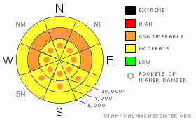
BOTTOM LINE
Danger by aspect and elevation on slopes approaching 35° or steeper.
(click HERE for tomorrow's danger rating)
|
Danger Rose Tutorial
|
There is a CONSIDERABLE avalanche on mid elevation west through north through easterly facing slopes of about 35 degrees and steeper. You’ll still easily trigger soft slab avalanches about a foot deep and up to 150’ wide. The danger for natural and human triggered loose snow avalanches will rise significantly with provocation. If the northeasterly winds pick up more than expected, wind slab development is likely high on the southerly aspects. Remember - Terrain is your friend – choose terrain that will have you come home at the end of the day. |
|
|
CURRENT CONDITIONS |

|
Skies are clearing in the wake of this last round of snow. Current high temps are in the single digits, current lows are well below zero. Feels like winter. With the passing of the storm, winds veered to the north and northeast with all anemometers pegged below 15mph. Which is a good thing. Since Thursday, we’ve had roughly 12-15” in Provo and the Cottonwoods and about 4-8” most everywhere else. Densities are a beautiful 5-7%. Riding conditions are spectacular, even on the lower angle slopes (where most of us should be-more on this in a minute).
Doug Wewer – scientist, aesthete, and skier (and not necessarily in that order) has taken some wonderful photographs of the new snow (crystals) lately. Check them out. |
|
|
RECENT ACTIVITY |

|
It’s honestly been too busy. Twelve skier triggered slides yesterday and perhaps one 2’ deep natural in upper Porter Fork of Mill Creek. I’m thinking that there have been over 40 reported human triggered slides in the last three days alone. How many have gone unreported? Yesterday’s were soft slabs 12-18” deep, averaging 50’ wide. One ran over 2000’ down the slope. These were on west to northeast facing slopes between roughly 8600’ and 9600’ with some slope angles in the lower 30s. (They're all updated on our Current Conditions page)
None of this is surprising. What is surprising is that this is continuing day after day after day. It clearly says something about the persistent weak layers (surface hoar and surface facets) formed Feb 8-10, but it also says something about us.
This came in last night:
"You guys have obviously identified the problem and the daily discussion on your website is right on. The hard thing for us skiers is standing on top of an 800 foot run of what looks to be perfect powder and turning back."
First: Stack the odds in your favor with better terrain choices.
Second: Realize that these are soft slabs only a foot deep and generally less than a 100’ wide. It’s like cheap insurance. These slides will not always be so forgiving. Luck may run out sooner or later; perhaps sooner (with today’s sun and potential wind) – and later – when these slabs become stiffer and deeper over the same weaknesses. Cheap insurance no longer – you might need what they call Catastrophic Insurance. |
|
|
THREAT #1 |

|
| WHERE |
PROBABILITY |
SIZE |
TREND |
|
|
|
|
| |
|
|
Over the next
24 hours.
|
|
|
As the very experienced skier who went for a ride in Butler Fork yesterday admitted, “the surface hoar is pockety. I was looking for it all day and dug at least 25 hasty pits. It wasn’t until the end of the day that I was complacent. My ski cut had the snow break above me and down I went.” It is indeed not everywhere, but most common on the west to north to east facing slopes between 8000’ and 10,000’. Outliers may be considered to be below 8000’ and more “off “than west and east. These will take more time to gain strength. Additional stress of sun and wind today will make these more sensitive to human and natural triggering. |
|
|
THREAT #2 |

|
| WHERE |
PROBABILITY |
SIZE |
TREND |
|
|
|
|
| |
|
|
Over the next
24 hours.
|
|
|
It’s been over two weeks since our last slides into the old snow. February 7th, to be exact – a fateful day of incidents off Wilson Peak and Gobbler’s Knob in upper Mill Creek and a close call in Upper Days Fork. The deeper weaknesses continue to gain strength in areas that have a solid base of up to 6’ or more. It should be noted that none of these bazillion slides over the past week or so have stepped down into the old snow. Still, I aim to avoid thin, rocky snowpack areas facing northwest through southeast are the likely terrain to trigger a slide to the ground. Better for the insurance policy. |
|
|
THREAT #3 |

|
| WHERE |
PROBABILITY |
SIZE |
TREND |
|
|
|
|
| |
|
|
Over the next
12 hours.
|
|
|
Wet and dry sluffing will be commonplace today on all the steepest slopes at the mid and upper elevations. Direct sun with a higher angle of incidence will easily prod both dry and wet loose slides today. There’s quite a bit of snow that can be entrained along the way. |
|
|
MOUNTAIN WEATHER |

|
The bluebird will sing today. Sunny skies, light-increasing-to-moderate northeasterly winds, and cool temps in the teens. High pressure persists into tomorrow with a series of disturbances Thursday through the weekend. |
|
|
GENERAL ANNOUNCEMENTS |
|
Discount Lift tickets: Ski Utah, Backcountry.com, Alta, Deer Valley, Park City, The Canyons, Wolf Mountain, Snowbasin, Beaver Mountain, Brighton, Sundance, and Solitude have donated a limited number of tickets for sale at discounted prices.
Wasatch Powderbird Guides flight plan.
Dawn Patrol Forecast Hotline, updated by 05:30:888-999-4019 option 8.
Daily observations are frequently posted by 10 pm each evening.
Free UAC iPhone app from Canyon Sports.
Subscribe to the daily avalanche advisory e-mail click HERE.
UDOT canyon closures UDOT at (801) 975-4838
We appreciate all your avalanche and snow observations. You can also call us at 801-524-5304 or 800-662-4140, or email to uac@utahavalanchecenter.org
Donate to your favorite non-profit – The Friends of the Utah Avalanche Center. The UAC depends on contributions from users like you to support our work.
The information in this advisory is from the U.S. Forest Service, which is solely responsible for its content. This advisory describes general avalanche conditions and local variations always occur.
We will update this forecast tomorrow morning. Thanks for calling. |
|
|
This information does not apply to developed ski areas or highways where avalanche control is normally done. This advisory is from the U.S.D.A. Forest Service, which is solely responsible for its content. This advisory describes general avalanche conditions and local variations always occur. |
|
This advisory provided by the USDA Forest Service, in partnership with:
The Friends of the Utah Avalanche Center, Utah Division of State Parks and Recreation, Utah Division of Emergency Management, Salt Lake County, Salt Lake Unified Fire Authority and the friends of the La Sal Avalanche Center. See our Sponsors Page for a complete list. |
