SPECIAL ANNOUNCEMENT |
 |
We are updating this advisory only on an intermittent basis as conditions warrant. The next advisory will likely be on Friday.
According to our calculations, if we get less than 20 inches of snow for the rest of April, we will break the all-time record for the least amount of snow in a season at the Alta Guard Station--where snow record keeping goes back 67 years!. The record is the infamous winter of 1976-77.
Personally, I'm rooting to put this winter out of its misery. Let's go for the record! |
|
|
BOTTOM LINE
Danger by aspect and elevation on slopes approaching 35° or steeper.
(click HERE for tomorrow's danger rating)
|
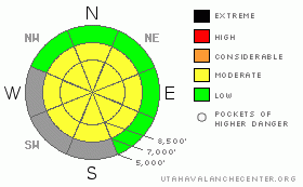
Danger Rose Tutorial
|
We expect the avalanche danger to rise to MODERATE during the storm tonight and Thursday morning for new snow and wind slabs. As usual, avoid any steep slopes with recent wind deposits.
After the storm, if the sun comes out, expect the usual damp and wet sluffs on steep, sun exposed slopes where the danger will also be MODERATE. As usual, avoid steep slopes and crossing under them when they get soggy in the heat of the sun. |
|
|
CURRENT CONDITIONS |

|
Temperatures have been very warm these past few days and very windy today. There is very little snow left on any of the south facing slopes until you get above about 8,000' in elevation. At least the corn has been good on the southerly aspects.
Remember you can always check the automated weather stations, snow amounts and forecast at the Snow Page. |
|
|
RECENT ACTIVITY |

|
There has not been much avalanche activity these past couple days but there were several wet sluffs and small wet slabs over the weekend. Remember you can always check for observations coming in every day on our Current Conditions page. |
|
|
THREAT #1 |

|
| WHERE |
PROBABILITY |
SIZE |
TREND |

|
|
|
|
| |
|
|
Over the next
24 hours.
|
|
|
The main concern is the storm arriving tonight. The forecast is for 3-5 inches of snow overnight into Thursday morning. The snow should, in theory, bond fairly well to the old, wet snow and I don't think it will be too much of a problem with the exception of fresh wind slabs mostly in the upper elevation terrain. As always, avoid steep slopes with recent wind drifts. Most of the wind slabs should be shallow, soft and manageable.
The forecast is for continued unsettled weather for the next couple days without too much accumulation and then another pulse on about Saturday and we should have similar avalanche conditions with this next pulse.
Note: the grey areas on the danger rose above indicate bare ground. |
|
|
THREAT #2 |

|
| WHERE |
PROBABILITY |
SIZE |
TREND |

|
|
|
|
| |
|
|
Over the next
24
hours.
|
|
|
I don't think we will see much sun for the next several days, but spring weather forecasts are always tricky at best. After the storm IF the sun makes the new snow damp or wet, you can expect the usual round of wet sluffs and occasional wet slabs within the new snow. As usual, avoid steep slopes if they get soggy in the heat of the strong spring sun. Like I say, I don't expect this to happen be we always have to mention it in spring. |
|
|
MOUNTAIN WEATHER |

|
We have a large, cold trough settling over us through the weekend with most of the energy going south of us into southern Utah and Arizona. This will keep our weather unsettled and cool. The forecast is for 3-5 inches of snow overnight and then light snow showers for the next couple days with another pulse for about Saturday. Storm totals the end of the weekend should be in the 8-12 inch range.
Ridgetop winds will blow hard today from the south turning westerly on Thursday. Precipitation should start this evening and continue into Thursday morning. Temperatures will drop to the mid 20's at night and rise to near freezing each day through the weekend.
Since this is an intermittent advisory, you can check the weather anytime you want at the following handy links:
Cottonwood Canyons forecast (updated twice per day)
Graphical weather forecast(updated 4 times per day) |
|
|
GENERAL ANNOUNCEMENTS |
If you trigger an avalanche in the backcountry - especially if you are adjacent to a ski area – please call the following teams to alert them to the slide and whether anyone is missing or not. Rescue teams can be exposed to significant hazard when responding to avalanches, and do not want to do so when unneeded. Thanks.
Salt Lake and Park City – Alta Central (801-742-2033)
Ogden – Snowbasin Patrol Dispatch (801-620-1017)
Provo – Sundance Patrol Dispatch (801-223-4150)
Dawn Patrol Forecast Hotline, updated by 05:30:888-999-4019option 8.
Twitter Updates for your mobile phonehttp://utahavalanchecenter.org/twitter)
Daily observations are frequentlypostedby 10 pm each evening.
Subscribe to the daily avalanche advisory e-mail clickHERE.
UDOT canyon closuresUDOTat(801) 975-4838
Wasatch Powderbird Guides does daily updates about where they'll be operating on this bloghttp://powderbird.blogspot.com/.
Remember your information can save lives.If you see anything we should know about, please participate in the creation of our own community avalanche advisory by submittingavalanche and snow observations. You can also call us at801-524-5304or800-662-4140, or email by clickingHERE
Donate to your favorite non-profit –The Friends of the Utah Avalanche Center. The UAC depends on contributions from users like you to support our work.
We will update this forecast tomorrow morning. Thanks for calling. |
|
|
This information does not apply to developed ski areas or highways where avalanche control is normally done. This advisory is from the U.S.D.A. Forest Service, which is solely responsible for its content. This advisory describes general avalanche conditions and local variations always occur. |
|
This advisory provided by the USDA Forest Service, in partnership with:
The Friends of the Utah Avalanche Center, Utah Division of State Parks and Recreation, Utah Division of Emergency Management, Salt Lake County, Salt Lake Unified Fire Authority and the friends of the La Sal Avalanche Center. See our Sponsors Page for a complete list. |
