SPECIAL ANNOUNCEMENT |
 |
We will be holding 2 Know Before You Go avalanche awareness talks TONIGHT, Feb 15, one at the Swaner EcoCenter at Kimball Junction and one at the Black Diamond Retail Store in SLC, both at 7pm. Come see our NEW video, learn about our spooky snowpack, and learn how to stay safe in avalanche terrain. This 1 hour program is great for kids of all ages.
The Logan office of the Utah Avalanche Center still has a few spots left in their Avalanche Advanced Skills class this Thursday evening and Saturday. For more info, email toby@utahavalanchecenter.org.
The Utah Avalanche Center is holding a fundraising auction of donated gear to support forecasting and education. We have Black Diamond and Surface Skis, several OR jackets, a BCA airbag pack, and some Scarpa AT boots. Go to ebay and search for "Utah Avalanche Center” or click HERE. http://www.ebay.com/sch/i.html?_from=R40&_trksid=p5197.m570.l1312&_nkw=utah+avalanche+center&_sacat=See-All-Categories]..
We also still have discount lift tickets for Alta, Snowbird, Brian Head, Sundance, and Wolf Mountain. All proceeds go towards avalanche forecasting and education.
|
|
|
BOTTOM LINE
Danger by aspect and elevation on slopes approaching 35° or steeper.
(click HERE for tomorrow's danger rating)
|
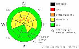
Danger Rose Tutorial
|
Most terrain has a MODERATE danger today. Isolated areas of CONSIDERABLE danger for triggering hard slabs 2-5' deep exist in the upper elevation northerly terrain. Consequences as severe as these rule my decision making. Good, safe and stable riding exists on slopes up to 30 degrees in steepness with nothing steeper above. |
|
|
CURRENT CONDITIONS |

|
Clouds danced with the sun, keeping many southerly aspects from “going off” and becoming sun damaged yesterday. As with springtime, these can be local effects – other parts of the range saw intermittent sun. Still, Sunday’s now settled few inches of snow with no wind effect has improved conditions dramatically. Winds this morning remain generally less than 15mph from the southeast; temps hover in the mid-teens. We'll see some light precipitation today with a sharply splitting storm diving well to the south.
|
|
|
RECENT ACTIVITY |

|
We heard of no new avalanching in the backcountry yesterday, though we did hear of one collapse in at roughly 9000’ on the north side of Gobbler’s Knob above Porter Fork of Mill Creek in the central Wasatch.
|
|
|
THREAT #1 |

|
| WHERE |
PROBABILITY |
SIZE |
TREND |
|
|
|
|
| |
|
|
Over the next
24 hours.
|
|
|
Our deep slab structure is undeniable. That there are only mostly yellow colors on the scale doesn't change the way in which I travel in the backcountry. Whether there is a 5% chance or 20% chance or 1% chance...I refuse to jump into the steep west to southeast facing terrain. Remember - Deep slabs are notoriously unpredictable - trigger spots can be hard to detect - and they are difficult to survive. |
|
|
THREAT #2 |

|
| WHERE |
PROBABILITY |
SIZE |
TREND |
|
|
|
|
| |
|
|
Over the next
24 hours.
|
|
|
The storm snow from Sunday seems to have healed, though we’re seeing quite a bit ofvariability in the state and distribution of the weak recrystallized snow and surface hoar from late Jan/early February. We’re seeing full propagation and clean shears in some areas; in other areas, the weaknesses seem to have “lost their edge” – literally – and now offer a more firm bond between the new snow and the old. Often coy and difficult to tease out when buried, the early Feb Surface Hoar (these beautiful feathers of wintertime dew) is found sparingly across the range.
Most, but not all, of these interfaces have adjusted to the new load over the last couple of days…though I imagine they could reactivate with the next additional load of snow and/or wind (perhaps this coming President’s Day weekend). Greg Gagne offers an excellent perspective from what he’s seen across the Tri-Canyons in regards to this interface. Just to the north in Ogden, Brian Smith and Doug Wewer’s are finding something entirely different – and what appears to be a dramatically more dangerous set-up – facet/crust/surface hoar awaiting the next significant storm.
|
|
|
MOUNTAIN WEATHER |

|
We'll have mostly cloudy skies with a few showers - perhaps an inch or two expected during the day. Winds are expected to remain light. Temps will be in the upper teens. The Pacific storm dives way south and we'll find ourselves in between until the weekend. An active weather pattern from the northwest kicks in then through the early part of the week. |
|
|
GENERAL ANNOUNCEMENTS |
If you trigger an avalanche in the backcountry - especially if you are adjacent to a ski area – please call the following teams to alert them to the slide and whether anyone is missing or not. Rescue teams can be exposed to significant hazard when responding to avalanches, and do not want to do so when unneeded. Thanks.
Salt Lake – Alta Central (801-742-2033)
Ogden – Snowbasin Patrol Dispatch (801-620-1017)
Provo – Sundance Patrol Dispatch (801-223-4150)
Dawn Patrol Forecast Hotline, updated by 05:30: 888-999-4019 option 8.
Twitter Updates for your mobile phone http://utahavalanchecenter.org/twitter)
Daily observations are frequently posted by 10 pm each evening.
Subscribe to the daily avalanche advisory e-mail click HERE.
UDOT canyon closures UDOT at (801) 975-4838
Wasatch Powderbird Guides does daily updates about where they'll be operating on this blog http://powderbird.blogspot.com/ .
You have the opportunity to participate in the creation of our own community avalanche advisory by submitting avalanche and snow observations. You can also call us at 801-524-5304 or 800-662-4140, or email by clicking HERE
Donate to your favorite non-profit –The Friends of the Utah Avalanche Center. The UAC depends on contributions from users like you to support our work.
We will update this forecast tomorrow morning. Thanks for calling. |
|
|
This information does not apply to developed ski areas or highways where avalanche control is normally done. This advisory is from the U.S.D.A. Forest Service, which is solely responsible for its content. This advisory describes general avalanche conditions and local variations always occur. |
|
This advisory provided by the USDA Forest Service, in partnership with:
The Friends of the Utah Avalanche Center, Utah Division of State Parks and Recreation, Utah Division of Emergency Management, Salt Lake County, Salt Lake Unified Fire Authority and the friends of the La Sal Avalanche Center. See our Sponsors Page for a complete list. |
