BOTTOM LINE
Danger by aspect and elevation on slopes approaching 35° or steeper.
(click HERE for tomorrow's danger rating)
|
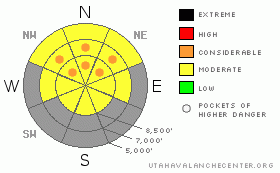
Danger Rose Tutorial
|
There's a level 2 or Moderate danger in the backcountry. Heightened wet avalanche conditions will develop again this weekend, as surface snow becomes moist with daytime heating. The avalanche danger will continue to rise through the weekend and into early next week, and the danger may rise to level 3 or Considerable, with wet sluffs likely and wet slab avalanches possible.Evaluate the snow and terrain carefully, and avoid steep slopes with moist and melt-softened snow... |
|
|
CURRENT CONDITIONS |

|
It's 40 degrees up the the 8400' Tony Grove Snotel and there is 50 inches of snow containing 64% of normal water content for the date. The station reported 3 inches of new snow on Thursday. The 9700' CSI Logan Peak weather station also reports 40 degrees and southwest winds averaging between 15 and 20 mph....
|
|
|
RECENT ACTIVITY |

|
Some natural wet avalanche activity was reported in the Logan Zone last weekend... And there were a couple small and manageable triggered wet avalanches as well.
(go to our current conditions page for more details on the local activity and reports of many other recent avalanches and conditions in the backcountry across the mountains of Utah) |
|
|
THREAT #1 |

|
| WHERE |
PROBABILITY |
SIZE |
TREND |
|
|
|
|
| |
|
|
Over the next
12 hours.
|
|
|
Heightened avalanche conditions will develop rapidly this weekend with daytime warming, and triggered wet avalanches are possible on steep slopes with saturated snow. Loose wet avalanches involving moist surface snow could entrain more snow than you might expect, especially on long sustained pitches... The danger will rise as temperatures go through the roof in the next couple days |
|
|
MOUNTAIN WEATHER |

|
Expect fair weather and exceptionally warm temperatures this weekend, with 8500' high temperatures in the mid 50s tomorrow and the lower 60s on Sunday and Monday... Overnight temperatures should stay well above freezing, so any surface refreeze will be superficial at best... |
|
|
GENERAL ANNOUNCEMENTS |
I recently published some historical photos of the Huge Wood Camp avalanche from 2-20-1986.... Click HERE
Please consider a donation to your favorite non-profit –The Friends of the Utah Avalanche Center. The Utah Avalanche Center depends on contributions from users like you to support our work.....
Please send us your observations from the backcountry especially if you see or trigger an avalanche, but also even if you don't.. go to avalanche and snow observations. You can also call me directly at 435-757-7578 or leave us a message at our office, 801-524-5304.... And, you can always send us a simple email by clicking HERE
For the month of April, I will update this advisory intermittently as needed and on weekends...
This advisory is from the U.S.D.A. Forest Service, which is solely responsible for its content. This advisory describes general avalanche conditions and local variations always occur. |
|
|
This information does not apply to developed ski areas or highways where avalanche control is normally done. This advisory is from the U.S.D.A. Forest Service, which is solely responsible for its content. This advisory describes general avalanche conditions and local variations always occur. |
|
This advisory provided by the USDA Forest Service, in partnership with:
The Friends of the Utah Avalanche Center, Utah Division of State Parks and Recreation, Utah Division of Emergency Management, Salt Lake County, Salt Lake Unified Fire Authority and the friends of the La Sal Avalanche Center. See our Sponsors Page for a complete list. |
