BOTTOM LINE
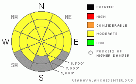
Danger by aspect and elevation on slopes approaching 35° or steeper.
(click HERE for tomorrow's danger rating)
|
Danger Rose Tutorial
|
Heightened avalanche conditions will rapidly develop as the day warms, with mountain temperatures forecast 10 degrees warmer than yesterday's. There's a level 2 or Moderate danger in the backcountry, with a rising danger of wet avalanches and deep slab avalanches still possible on some steep slopes. Lacking a good overnight refreeze, shallow surface crusts will rapidly soften in today's heat and the danger of wet avalanches could become fairly widespread. Dangerous deep slab avalanches remain possible on very steep slopes in isolated areas with thin snow coverage, mostly at upper elevations. Evaluate the snow and terrain carefully, and avoid steep terrain with warming or already saturated snow and upper elevation rocky terrain with shallow snow. |
|
|
CURRENT CONDITIONS |

|
After a very warm night, expect only a superficial refreeze and fairly rapid softening. with today's temperatures around 10 degrees warmer than yesterday's. It's already 45 degrees up the the 8400' Tony Grove Snotel and there is 65 inches of snow containing 76% of normal water content for the date. The 9700' CSI Logan Peak weather station reports 41 degrees and south winds averaging in excess of 30 mph with gusts pushing 50....
|
|
|
RECENT ACTIVITY |

|
No significant avalanche activity was reported in the Logan Zone for well over a week now...
(go to our current conditions page for more details on the local activity and reports of many other recent avalanches and conditions in the backcountry across the mountains of Utah) |
|
|
THREAT #1 |

|
| WHERE |
PROBABILITY |
SIZE |
TREND |

|
|
|
|
| |
|
|
Over the next
12 hours.
|
|
|
Heightened avalanche conditions will develop more rapidly today with daytime warming, and triggered wet loose and slab avalanches are possible on steep slopes with saturated snow. Dangerous wet slab avalanches failing on moist depth hoar are possible on some steep slopes with poor snow structure and will become even more possible with exceptionally warm mountain temperatures expected today. |
|
|
THREAT #2 |

|
| WHERE |
PROBABILITY |
SIZE |
TREND |

|
|
|
|
| |
|
|
Over the next
12 hours.
|
|
|
Depth hoar still plagues the basal snowpack in some areas, and you might trigger a dangerous deep slab avalanche on an isolated steep slope, particularly in areas with generally shallow and weak snow... On some slopes with poor snow structure, an overrunning cornice fall, wind slab, or a smaller wet avalanche might trigger a more dangerous and destructive deep slab avalanche... Exceptionally very warm temperatures today could increase the creep rate and soften the existing slab layer on some slopes, and free water from melt may lubricate and weaken the weak depth hoar in places, causing the danger to increase... |
|
|
THREAT #3 |

|
| WHERE |
PROBABILITY |
SIZE |
TREND |

|
|
|
|
| |
|
|
Over the next
36 hours.
|
|
|
Sagging cornices might break further back than you expect, and cornice falls could trigger larger avalanches on steep slopes below.
Fresh wind slabs will probably form tomorrow in exposed upper elevation terrain, with a few inches of fresh snow and westerly winds forecast... You might trigger a wind slab avalanche on Sunday in steep drifted terrain on the lee side of exposed ridges, or in and around terrain features like gully walls, scoops, cliffs, and sub-ridges. |
|
|
MOUNTAIN WEATHER |

|
It will be very warm and very windy today in the mountains, with 8500' high temperatures forecast at 56 degrees and southwest winds averaging 30 to 35 mph and gusts in the 50s.... Winds will even intensify overnight, temperatures should drop below freezing, and snow showers will develop, but little accumulation is expected... 2 to 4 inches of accumulation is forecast for tomorrow, with a moderate northwest wind. Expect gradual clearing and rather benign weather through the first half of next week... |
|
|
GENERAL ANNOUNCEMENTS |
I recently published some historical photos of the Huge Wood Camp avalanche from 2-20-1986.... Click HERE
Please consider a donation to your favorite non-profit –The Friends of the Utah Avalanche Center. The Utah Avalanche Center depends on contributions from users like you to support our work.....
Please send us your observations from the backcountry especially if you see or trigger an avalanche, but also even if you don't.. go to avalanche and snow observations. You can also call me directly at 435-757-7578 or leave us a message at our office, 801-524-5304.... And, you can always send us a simple email by clicking HERE
For the month of April, I will update this advisory intermittently as needed and on weekends...
This advisory is from the U.S.D.A. Forest Service, which is solely responsible for its content. This advisory describes general avalanche conditions and local variations always occur. |
|
|
This information does not apply to developed ski areas or highways where avalanche control is normally done. This advisory is from the U.S.D.A. Forest Service, which is solely responsible for its content. This advisory describes general avalanche conditions and local variations always occur. |
|
This advisory provided by the USDA Forest Service, in partnership with:
The Friends of the Utah Avalanche Center, Utah Division of State Parks and Recreation, Utah Division of Emergency Management, Salt Lake County, Salt Lake Unified Fire Authority and the friends of the La Sal Avalanche Center. See our Sponsors Page for a complete list. |
